A. Regulations – General.
1. All new shoreline uses and shoreline modification activities, including those that do not require a shoreline substantial development permit, must conform to all applicable goals, policies, shoreline designations (including the shoreline designation map), and regulations and use tables provided in this master program.
2. Shoreline modification activities must be in support of an allowable shoreline use which conforms to the provisions of the master program. Except as otherwise noted, all shoreline modification activities not associated with a legally existing or approved shoreline use are prohibited.
3. Shoreline uses, modification activities, and conditions listed as prohibited in Table 16.12.030-1 shall not be eligible for consideration as a shoreline variance or shoreline conditional use permit.
4. Uses, modification activities, and conditions that are not prohibited and not listed in Table 16.12.030-1 shall be reviewed through the shoreline conditional use process.
5. The policies listed in the master program shall provide broad guidance and direction and shall be used by the director in interpreting the regulations.
6. BIMC Title 18, Zoning, or its successor also apply to shoreline parcels.
7. Where provisions of this master program or other provisions in BIMC conflict, the conflict shall be resolved by the director of planning and community development by applying the provision that provides the most protection of shoreline ecological functions consistent with the purposes and intent of the Shoreline Management Act. If the director’s decision is made in response to a code interpretation request filed under BIMC 2.16.020.D, the decision shall be appealable in the same manner as other code interpretations. If the director’s decision is made in the processing of a development permit, the director’s decision shall be appealable as part of the permit decision.
8. The use table (Table 16.12.030-1), shoreline setback table (Table 16.12.030-2), and the shoreline buffer table (Table 16.12.030-3) provide regulatory use and dimensional provisions for each shoreline designation.
9. An increase in the dimensional height standard (Table 16.12.030-2) for essential public facilities shall be reviewed through a shoreline conditional use. Submittal requirements are in the administrative manual.
10. Submittal requirements for all shoreline development permits or shoreline exemptions are in BIMC Title 2 and the administrative manual.
EXPLANATION OF TABLE ABBREVIATIONS
The abbreviations used in the Permitted Use Table have the following meanings:
ο “P” in a cell indicates that the use is permitted by right in that designation. Permitted uses are subject to all other applicable regulations of this program, including the use-specific standards.
ο “C” in a cell indicates that, in the respective designation, the use is a conditional use that is allowed only if reviewed and approved in accordance with the procedures set forth in BIMC Title 2. Unless otherwise stated in this program or in a conditional use approval, conditional uses are subject to all other applicable regulations of this code, including the use-specific standards.
ο An “A” in a cell indicates that the use is permitted as an accessory use to a permitted use or to an approved conditional use in the same designation. In the case of approved conditional uses, accessory uses listed in the table are permitted unless the terms of the conditional use permit prohibit that accessory use.
ο A “CA” in a cell indicates that the use is permitted as an accessory use to a permitted use or to an approved conditional use, but that a conditional use permit is always required.
ο An “X” indicates that the use is prohibited in the respective designation. The use may be allowed outside the shoreline jurisdiction. See BIMC Title 18, Zoning.
ο The column headed “Use Specific Standards” identifies a subsection within this chapter that imposes additional standards with which the use must comply. The use specific standard may limit the “P” or “C” designation to certain areas.
B. Environmental Quality and Conservation.
1. Shorelines of Statewide Significance.
a. Purpose. The Shoreline Management Act of 1971 designated certain shoreline areas as shorelines of statewide significance (SSWS). Because these shorelines are resources from which all people in the state derive benefit, preference is given to uses which favor public and long-range goals.
b. Applicability. Within the city’s jurisdiction all those areas lying waterward from the line of extreme low tide are shorelines of statewide significance (RCW 90.58.030(2)(f)(iii) or its successor). Development, use, or activities located within shorelines of statewide significance shall follow all the provisions of this program. Proposed development, use, and activity within shorelines of statewide significance shall be reviewed in accordance with the policies of the shoreline master program. The administrator may reduce, alter, or deny proposed development, use, or activity to satisfy the preferred policy.
2. Environmental Impacts.
a. Applicability. All shoreline development and activity shall be located, designed, constructed, and managed in a manner that avoids, minimizes and/or mitigates adverse impacts to the shoreline environment. The preferred mitigation sequence (avoid, minimize, rectify, reduce, or compensate for the environmental impact) shall follow that listed in WAC 173-26-201(2)(e). See definition of “mitigation” listed in BIMC 16.12.080, Definitions.
In approving shoreline development, the city shall ensure that shoreline development, use, and/or activities will result in no net loss of ecological functions and ecosystem-wide processes necessary to sustain shoreline resources, including loss that may result from the cumulative impacts of similar developments over time consistent with constitutional and statutory limitations on the regulation of private property. To this end, the city may require modifications to the site plan and/or adjustments to proposed project dimensions, intensity of use, and screening, as deemed appropriate. If impacts cannot be avoided through design modifications, the city shall require compensatory mitigation commensurate with the project’s adverse impacts.
b. Regulations – Impact Analysis and No Net Loss Standard.
i. All shoreline development, use and activities, including preferred uses and uses that are exempt from a shoreline substantial permit, shall be located, designed, constructed, and maintained in a manner that protects ecological functions and ecosystem-wide processes. All proposed shoreline development, uses and activities shall:
(A) Utilize the required mitigation sequence of subsection B.2.d of this section, Regulations – Mitigation; and
(B) Utilize effective erosion and scour control methods during project construction and operation; and
(C) Minimize adverse impacts to critical salt water habitat, fish and wildlife conservation areas, and/or other ecological functions and ecosystem-wide processes, such as those provided by shoreline vegetation; and
(D) Minimize interference with beneficial natural shoreline processes, such as water circulation, sand and gravel transport movement, erosion, and accretion; and
(E) Avoid hazards to public health and safety; and
(F) Minimize the need for shoreline stabilization measures and flood protection in the future; and may require a geotechnical analysis to ensure that the proposed activity meets this regulation (see BIMC 16.12.050.B, Shoreline Stabilization); and
(G) Result in no net loss of ecological functions and processes necessary to sustain shoreline resources, including loss that may result from the cumulative impacts of similar developments over time.
ii. In reviewing and approving shoreline development, use or activity, regardless of whether a permit is required the following shall apply:
(A) The administrator shall condition the shoreline development, use, and/or activities such that it will:
(1) Meet provisions in subsection B.2.b.i of this section; and
(2) Employ measures to mitigate adverse impacts on shoreline functions and processes, if necessary; and
(3) Modify the site plan and/or adjust the project dimensions, intensity of use, or screening as deemed appropriate to address impacts. If impacts cannot be avoided through design modification, the administrator shall require compensatory mitigation, pursuant to regulations in subsections B.2.c, Regulations – Revegetation Standards, and B.2.d, Regulations – Mitigation, of this section; and
(B) If a proposed shoreline development, use or activity is determined by the administrator to result in significant short-term, long-term, or cumulative adverse environmental impacts lacking appropriate compensatory mitigation, it shall be sufficient reason for the administrator to deny a permit.
iii. To assure that development activities contribute to meeting the no net loss provisions pursuant to subsections B.2.b.i and ii of this section, an applicant is required to submit a site-specific analysis of potential impacts and a mitigation plan that includes compensatory mitigation measures when determined necessary as a result of the analysis. The site-specific analysis shall be prepared in accordance with the submittal requirements in the administrative manual.
iv. To mitigate anticipated impacts and meet the no net loss standards in subsections B.2.b.i and ii of this section, an applicant for a single-family residential development or accessory structures may choose to use the Single-Family Residential Mitigation Manual in the Administrative Manual in lieu of a site-specific impact analysis and mitigation plan. If an applicant uses the Single-Family Residential Mitigation Manual, compensatory mitigation requirements provided in the manual shall be included in the project submittal.
c. Regulations – Revegetation Standards.
i. Vegetation replanting is required for all development, uses or activities within the 200-foot shoreline jurisdiction that either alters existing native vegetation or any vegetation in the required shoreline buffer or vegetation management areas, whether a permit is required or not. This includes invasive species removal. Minimum requirements for planting plans can be found in the city’s Administrative Vegetation Management Manual. The following information shall be submitted for approval prior to vegetation disturbance as part of a project proposal or clearing permit pursuant to Chapter 15.18 BIMC, Land Clearing:
(A) Residential, Industrial and Commercial Development.
(1) Vegetation disturbance of 200 square feet or less requires submittal of an annotated list of proposed plants and their spacing specifications and location.
(2) Vegetation disturbance greater than 200 square feet requires that the planting plan shall be completed by a qualified professional or the applicant may use the Single-Family Residential Mitigation Manual.
(B) Public Park and City Maintained Areas.
(1) Vegetation disturbance of 2,500 square feet or less requires submittal of an annotated list of proposed plants and their spacing specifications and location.
(2) Vegetation disturbance greater than 2,500 square feet requires that the planting plan shall be completed by a qualified professional.
ii. For vegetation mitigation in the shoreline buffer or site-specific vegetation management areas, all new plantings shall meet the provisions in subsection B.3.c.v of this section, except for the Point Monroe District, which shall meet special provisions in subsection B.2.c.vi of this section.
iii. If the shoreline buffer is altered or reduced pursuant to provisions of subsection B.3 of this section, Vegetation Management, the following shall occur in Zone 1:
(A) Retain existing native vegetation; and
(B) Plant the entire area of Zone 1. Obtain 65 percent vegetation canopy coverage within 10 years.
iv. When vegetation mitigation is required for new upland development, uses, or activities the mitigation plan shall include new plantings that are protective of views from the primary structure of the subject property and in proportion to the identified impact. Mitigation shall be located in the following sequence, except for the Point Monroe District, which shall meet special provisions in subsection B.2.c.vi of this section:
(A) Within Zone 1, plant vegetation to obtain a minimum of 65 percent native vegetation canopy coverage;
(B) In Zone 2, plant to increase canopy coverage, in a manner that promotes contiguous native vegetation or in areas nearest the shoreline;
(C) In the shoreline buffer, plant in a manner that promotes a contiguous native vegetated corridor that connects to the shoreline;
(D) Outside of the shoreline buffer, plant in a manner that promotes a contiguous native vegetated corridor to the shoreline;
(E) Outside of the shoreline buffer; or
(F) At an off-site location approved by the administrator, within Zone 1, plant to meet the standard of subsection B.2.c.iv.A of this section.
v. When mitigation is required for shoreline stabilization projects due to site disturbance, the required planting plan shall also include the following, unless an alternative planting plan is approved by the administrator:
(A) Replant 75 percent of the shoreline area located along the upland edge of the shoreline stabilization structure to a minimum depth of 10 feet, unless demonstrated to be infeasible to the administrator;
(1) The depth may be reduced to five feet to allow for landscape design variation; provided, that the total square footage of the area planted equals the required 75 percent of the shoreline;
(B) Planting plans shall meet provisions in subsection B.3.c.v of this section, and shade bearing plants shall be provided at suitable fish spawning sites; and
(C) Include plantings equivalent to one tree per every 20 linear feet of shoreline and one shrub per every five linear feet, which may be planted with due consideration of views from the primary structure of the subject property.
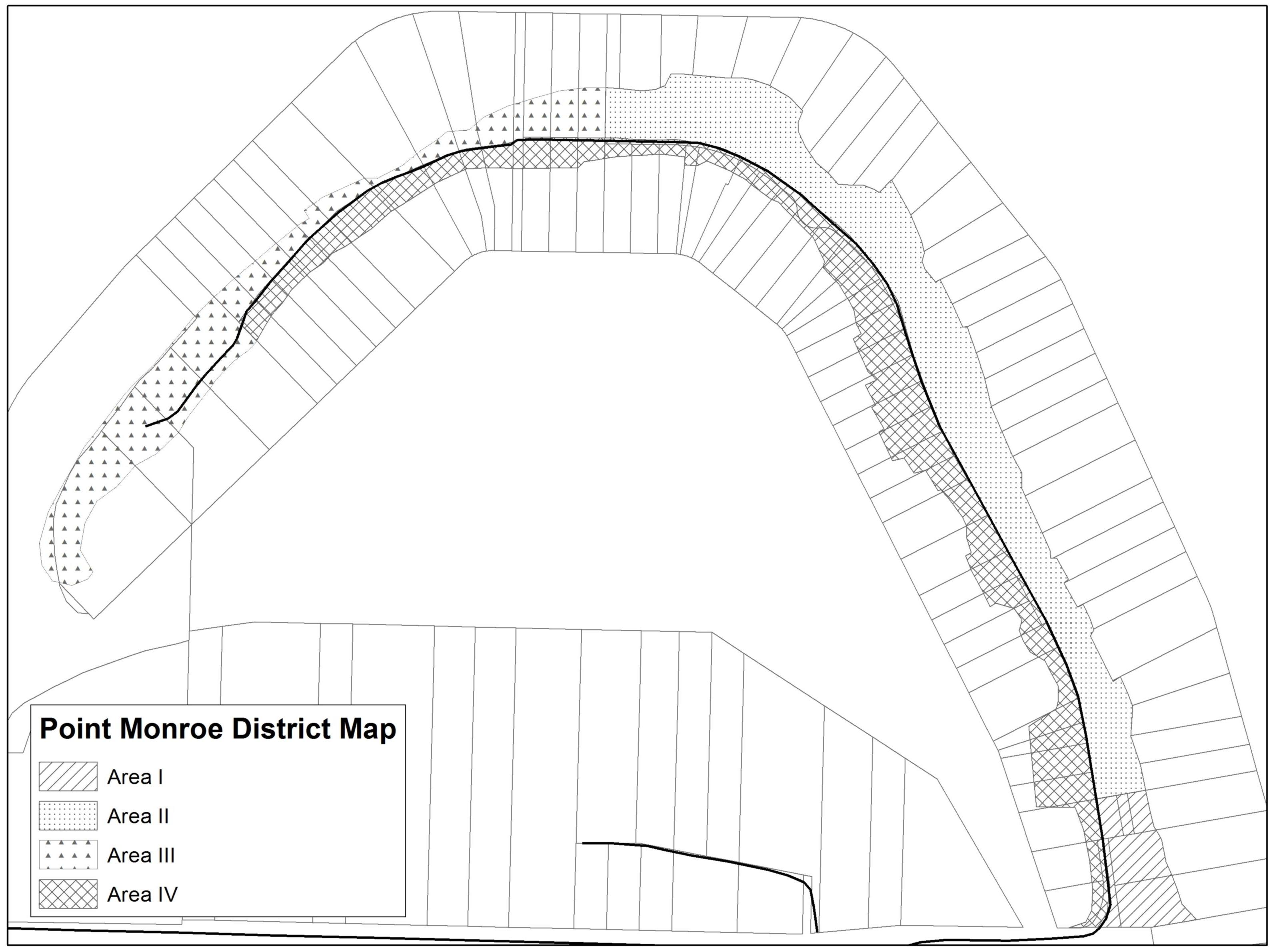
vi. Special Mitigation Provisions for Point Monroe District. When vegetation mitigation is required for new development, uses, or activities in the Point Monroe District, the mitigation plan shall include new vegetation communities appropriate for dune, sand spit, barrier beach, barrier estuary, or barrier lagoon, including salt marsh, that shall be installed within the site-specific vegetation management area (SVMA) as defined in subsection B.3.c.ix of this section, 30-foot setback between the OHWM and the primary structure, or where area is available on the site.
d. Regulations – Mitigation.
i. Mitigation Sequence. Mitigation shall include the following actions in order of priority (A) through (E), and (F) is required for all mitigation activities:
(A) Avoiding the impact altogether by not taking a certain action or parts of an action;
(B) Minimizing impacts by limiting the degree or magnitude of the action and its implementation by using appropriate technology or by taking affirmative steps to avoid or reduce impacts;
(C) Rectifying the impact by repairing, rehabilitating, or restoring the affected environment;
(D) Reducing or eliminating the impact over time by preservation and maintenance operations;
(E) Compensating for the impact by replacing, enhancing, or providing substitute resources or environments; and
(F) Monitoring the impact and the compensation projects and taking appropriate corrective measures.
ii. When compensatory mitigation is necessary to offset impacts, mitigation measures in the immediate vicinity of the impact shall be the preferred mitigation option. Property owners may be required to perform the balance of compensatory mitigation off site if the property cannot support required mitigation or when off-site mitigation can be demonstrated to the satisfaction of the administrator to be more beneficial to shoreline ecological functions and processes. For example, off-site mitigation may be the better choice if large, cohesive areas are available off-site while only small fragmented areas are available on site for mitigation.
iii. Mitigation actions shall not have a significant adverse impact on other preferred shoreline uses promoted by the policies of the Shoreline Management Act.
iv. When compensatory mitigation measures are required, all of the following shall apply:
(A) The quality and quantity of the replaced, enhanced, or substituted resources shall be the same or better than the affected resources; and
(B) The mitigation site and associated vegetative planting shall be nurtured and maintained such that healthy native plant communities can grow and mature over time; and
(C) Unless the Single-Family Residential Mitigation Manual is being used for single-family residential development and accessory structures pursuant to subsection B.2.b.iv of this section, the mitigation shall be informed by pertinent scientific and technical studies, including but not limited to the Shoreline Inventory and Characterization Report, the Shoreline Restoration Plan and other background studies prepared in support of this program; and
(D) The mitigation activity shall be monitored and maintained to ensure that it achieves its intended functions and values, pursuant to subsection B.2.e of this section, Regulations – Surety.
v. To encourage shoreline property owners to remove bulkheads and perform other beneficial shoreline restoration actions in advance of shoreline development or redevelopment, the city may give mitigation credit to any beneficial restoration action that occurred within 10 years of the proposed development/redevelopment activity; provided, that:
(A) The applicant/property owner declares the intent of the restoration or enhancement project as mitigation credit at the time of the restoration permit application; and
(B) The city can confirm via site inspection, photographs, or other evidence that the restoration actions have improved shoreline conditions.
vi. Where feasible, replacement compensatory mitigation should be required prior to impact and, if applicable, prior to final inspection and approval of building occupancy; and to ensure no net loss, the mitigation shall replace the functions as quickly as possible following the impact.
e. Regulations – Surety.
i. The applicant/property owner shall provide assurance to the satisfaction of the administrator that the restoration area (including off-site mitigation) will be maintained in perpetuity. The assurance can be in the form of notice on title, conservation easement, or similar mechanism as approved by the city attorney.
ii. Except for projects undertaken by public entities, performance and/or maintenance bonds or other security shall be required by the city to assure that work is completed, monitored, and maintained. The bond/surety shall be refunded to the depositor upon completion of the mitigation activity and any required monitoring.
f. Regulations – Monitoring and Maintenance.
i. When mitigation is required, a periodic monitoring program shall be included as a component of the required mitigation plan. To ensure the success of the required mitigation, monitoring shall occur for a minimum duration of five years from the date of the completed development. The monitoring plan may also require that periodic maintenance measures be included as recommended by a qualified professional. The duration of monitoring may be extended if the project performance standards set forth in the approved mitigation plan fail to be accomplished, or, due to project complexity, the approved mitigation plan requires a longer period of monitoring.
ii. Monitoring programs may be forwarded for review and comment to state and/or federal resource agencies and affected tribes with jurisdiction.
iii. Monitoring programs shall meet the requirements established in subsection B.5.n of this section, Critical Area Reports.
iv. All new and replacement shoreline stabilization projects shall complete and submit a minimum five-year monitoring and maintenance program that addresses the shoreline stabilization mitigation measures, and shall at a minimum include:
(A) An annual site visit by a qualified professional for each of the five years to assess the effectiveness of the mitigation; and
(B) A progress report submitted to the administrator annually, which includes any monitoring or maintenance recommendations of the qualified professional.
3. Vegetation Management.
a. Applicability. Vegetation management is required for protection and conservation within the shoreline jurisdiction. Dimensional and other development standards, including buffers, are established based on site-specific development and conditions or as specified for that particular shoreline designation. The purpose of vegetation management is to protect and enhance the island’s natural character, water quality, native plant communities, and wildlife habitat within the shoreline jurisdiction. Vegetation management activities will be reviewed under the no net loss provisions of subsection B.2 of this section, Environmental Impacts, and may also be reviewed under subsection A of this section, Regulations – General; subsection B.4 of this section, Land Modification; subsection B.5 of this section, Critical Areas; subsection B.6 of this section, Water Quality and Stormwater Management; and Chapter 15.18 BIMC, Land Clearing, when applicable. Other portions of this program may also apply.
Vegetation management includes conservation activities to protect and restore vegetation along or near marine and freshwater shorelines that contribute to the ecological functions and processes of shoreline areas. Vegetation management provisions include vegetation restoration, the prevention or restriction of plant clearing and earth grading, and the control of invasive weeds and nonnative vegetation species.
The vegetation management provisions apply to all shoreline development, and regulated uses and activities, including those that do not require a shoreline permit. Similar to other master program provisions, vegetation standards do not apply retroactively to existing uses and structures unless changes or alterations are proposed. Standards for vegetation management are established using current scientific and technical information pursuant to WAC 173-26-221(5)(b) and 173-26-201(2)(a), and are based on the use category, shoreline characterization and the designation. Standards are provided in subsection A of this section and Tables 16.12.030-2 and 16.12.030-3.
b. Regulations – Exceptions.
i. Vegetation management standards shall not apply retroactively to existing lawfully established conforming and nonconforming uses and developments, including maintenance of existing residential landscaping, such as lawns and gardens. Property owners are strongly encouraged to voluntarily improve shoreline vegetation conditions over the long term.
ii. Existing buffers and setbacks that have been established through previously approved subdivisions and indicated on the face of an approved plat shall be recognized and adhered to.
iii. The following shall be exempt from the provisions of subsection B.3 of this section:
(A) Maintenance trimming of vegetation that has a main stem or supporting structure which is less than three inches in diameter; except that tree topping or other vegetation removal is not exempt.
(B) Buffer enhancement through the removal of noxious or invasive weeds, provided the following are met:
(1) The vegetation removal is based on consultation with the Kitsap County Noxious Weed Board or the species being removed are on the Washington State Noxious Weed List (Chapter 16-750 WAC, or its successor); and
(2) The vegetation removal is conducted in a manner consistent with best management practices (BMP); and
(3) Replanting occurs in the disturbed area in accordance with subsection B.2.c of this section, Regulations – Revegetation Standards.
(C) Removal of hazard trees, where a report by an arborist or other qualified professional demonstrates to the satisfaction of the administrator that trimming is not sufficient to address the hazard, provided:
(1) Mitigation is provided in accordance with subsection B.2 of this section, Environmental Impacts, including:
(a) Requiring that the downed tree be retained on the site to provide or enhance wildlife or marine habitat; and/or
(b) When possible, require that the hazard tree be topped for safety and remain as a wildlife snag; or
(2) When a hazard tree is located in a geologically hazardous area, the applicant shall submit documentation of compliance with development standards pursuant to subsection B.5.k of this section, Regulations – Geologically Hazardous Areas – Applicability. The hazard tree may be removed prior to the approval of the plan if it is necessary to protect life and property.
(D) Commercial forest practices and the removal of trees pursuant to a forest practices permit (Class II, III and IV-S only) issued by the Washington State Department of Natural Resources under the Washington State Forest Practices Act (Chapter 76.09 RCW), except where such activities are associated with a conversion to other uses or other forest practice activities over which local governments have authority. For the purposes of this program, preparatory work associated with the conversion of land to nonforestry uses and/or developments shall not be considered a forest practice and shall be reviewed in accordance with the provisions for the proposed nonforestry use, the general provisions of this program, and shall be limited to the minimum necessary to accommodate an approved use.
c. Regulations – General.
i. Development within the shoreline jurisdiction shall be located and designed to protect existing native vegetation from disturbance to the fullest extent possible, to mitigate impacts to existing vegetation, and to meet the standard of no net loss of ecological functions and processes, subsection B.2 of this section, Environmental Impacts.
ii. Vegetation clearing, or grading, may not be undertaken within the shoreline jurisdiction without prior review and approval by the administrator, unless otherwise exempt under subsection B.3.b of this section, Regulations – Exceptions, or as provided in subsection B.3.c.vii of this section, with an approved standard operation procedure (SOP) manual. Clearing and grading may be subject to subsection B.4 of this section, Land Modification.
iii. Two alternative methods may be used to meet the goals and policies of the vegetation management section, as provided below, except the Point Monroe District shall meet the special provisions provided in subsection B.3.c.ix of this section:
(A) Site-Specific Vegetation Management Areas.
(1) As an alternative to the shoreline buffer dimensions provided in subsection B.3.c.iii.B of this section, an applicant may propose specific dimensional standards that meet the vegetation management goals and policies as determined through a habitat management plan (subsection B.5.n.iii of this section); provided, that the plan demonstrates the following:
(a) The proposed development is for a residential use.
(b) The site-specific proposal assures there is no net loss of the property’s specific shoreline ecological functions and associated ecosystem-wide processes pursuant to subsection B.2.b of this section, Regulations – Impact Analysis and No Net Loss Standard; and
(c) The site-specific proposal uses the scientific and technical information compiled to support the shoreline buffer standards of subsection B.3.c.iii.B of this section, and/or other appropriate technical information which, as determined by a qualified professional, demonstrates how the proposal protects ecological functions and processes and how it meets the goals and policies of this section.
(2) The habitat management plan shall be reviewed by the administrator in accordance with provisions in subsection B.5.n.iii of this section. The administrator may approve, approve with conditions, or deny the request. The administrator shall have the habitat management plan reviewed by an independent third party, the cost of which will be borne by the applicant.
(3) If the site-specific vegetation management area is approved, prior to permit issuance, the applicant shall record with the county auditor a notice on title, or other similar document subject to the approval of the administrator.
(B) As an alternative to a site-specific vegetation management area, a shoreline buffer shall be maintained immediately landward of the OHWM and managed according to provisions of this section. The shoreline buffer shall meet the location and design standards of subsection B.3.d of this section, Regulations – Shoreline Buffer – Location and Design Standard. The shoreline buffer shall be composed of two zones:
(1) Zone 1, an inner protective buffer area located immediately abutting the OHWM; and
(2) Zone 2, the remaining portion of the shoreline buffer located immediately abutting Zone 1.
iv. The shoreline buffer or site-specific vegetation management area shall be maintained in a predominantly natural, undisturbed and vegetated condition. Unless specifically allowed by this program, the following standards shall apply:
(A) All existing native groundcover, shrubs and significant trees located within the shoreline buffer or site-specific vegetation management area shall be retained.
(B) All activities shall be performed in compliance with the applicable standards contained in the vegetation management section, unless the applicant demonstrates that alternate measures or procedures are equal or superior in accomplishing the purpose and intent of the vegetation management section, including no net loss of ecological functions and ecosystem-wide processes.
(C) The use of pesticides is prohibited unless specifically allowed in subsection B.6 of this section, Water Quality and Stormwater Management.
v. New vegetation planted in the shoreline buffer or site-specific vegetation management area, unless otherwise provided for in the zone-specific requirements of subsection B.3.d.iv of this section, shall be:
(A) Native species using a native plant-community approach of multi-storied, diverse plant species that are native to the Central Puget Lowland marine riparian zone.
(B) Other plant species may be approved that are similar to the associated native species in diversity, type, density, wildlife habitat value, water quality characteristics, and slope stabilizing qualities, excluding noxious/invasive species; provided, that, as submitted by a qualified professional, it is demonstrated to the satisfaction of the administrator that the selected ornamental plants can serve the same ecological function as native plant species.
vi. Significant trees located outside the shoreline buffer or site-specific vegetation management area but within the shoreline jurisdiction shall be retained unless allowed to be removed under the exceptions or other provisions of this program, provided:
(A) The administrator may require alterations of a site plan in order to retain significant trees outside the shoreline buffer or vegetation management area. This may include minor adjustments to the location of building footprints, the location of driveways and access ways, or the location of walkways, easements or utilities.
vii. Vegetation clearing and maintenance activities, except those which are part of new construction, are allowed consistent with an approved SOP manual for vegetation maintenance and management of public parks, public trails, public rights-of-way or easements, publicly owned property, and/or other areas normally maintained by the city. A shoreline substantial development permit may be required for the SOP manual. The SOP manual shall include the following prescriptive elements:
(A) Procedures for maintaining vegetation on shoreline properties, shoreline trails or shoreline rights-of-way and easements, including procedures for noxious weed removal;
(B) Procedures for maintaining vegetation in critical areas, shoreline buffers, or site-specific vegetation management areas, or other sensitive land areas, including areas with cultural resources;
(C) Procedures for mitigation and vegetation replanting including appropriate species list; and
(D) Procedures for review and approval of allowed activities occurring under the scope of the SOP, including procedures for documenting activities.
viii. Minor vegetation removal outside the shoreline buffer or site-specific vegetation management area on a developed property not associated with new construction may be allowed, as provided in this program with an approved clearing permit, provided:
(A) The administrator may grant approval of minor vegetation clearing if it meets the provisions of this program and the following:
(1) The minor vegetation clearing allowed within a three-year period will include an area no greater than 200 square feet in area and/or no more than three nonsignificant trees per 20,000 square feet up to a maximum of six trees; and
(2) Native vegetation will not be removed from the shoreline buffer or vegetation management area; and
(3) All applicable standards of an approved vegetation management plan are met; and
(4) The replanting is performed pursuant to subsection B.2.c of this section, Regulations – Revegetation Standards; and
(5) Documentation of compliance with the development standards in subsection B.5.k of this section provided by a licensed geotechnical engineer for any vegetation alteration in a geologically hazardous area.
(B) Proposed clearing must meet the provisions of subsection B.2 of this section, Environmental Impacts, and subsection B.4 of this section, Land Modification.
ix. Special Provisions for Point Monroe District. Shoreline buffers or site-specific vegetation management areas are not required for properties located in the Point Monroe District; the following specific vegetation provisions shall apply:
(A) All properties in the Point Monroe District shall retain existing native vegetation and shall be subject to a Point Monroe vegetation management area (PVMA).
(B) The PVMA shall include areas that are:
(1) Within 30 feet of the OHWM and within the required side yard and the salt marsh fringe; and
(2) Outside any designated development area as approved pursuant to BIMC 16.12.040.I.4.b.
(C) The PVMA shall be managed and maintained in vegetation communities appropriate to dune, sand spit, barrier beach, barrier estuary, or barrier lagoon, including salt marsh.
(D) Developed properties shall retain existing native vegetation (including dune grass and salt marsh plant communities) in those areas that are not developed with legally established impervious surfaces.
(E) Any new development or alterations and expansion of existing development shall assess impacts to existing vegetation and meet the no net loss standard pursuant to subsection B.2 of this section, Environmental Impacts.
d. Regulations – Shoreline Buffer – Location and Design Standard.
i. The total depth of the shoreline buffer is based on the shoreline designation and the physical and most predominant geomorphic characteristics of the property. The depth of the shoreline buffer will be determined by the administrator according to criteria below.
(A) Property-specific physical and geomorphic characteristics of the particular lot will determine the maximum width (Category A) or minimum width (Category B) of the shoreline buffer, as follows:
(1) Shoreline Buffer Category A.
(a) The property contains or abuts a spit/barrier/backshore, or marsh, or lagoon; or
(b) The property contains or abuts a low bank and the existing native tree and shrub vegetation cover is at least 65 percent of the area of shoreline buffer Zone 1.
(2) Shoreline Buffer Category B. The property is shallow (200 feet in depth or less, as measured landward), or located on a high bluff, or does not meet any of the characteristics of Category A.
(B) Shoreline buffer standard depth in Table 16.12.030-3.
(C) As determined by the administrator, buffers do not extend beyond an existing public paved street or an area which is determined by the administrator to be functionally isolated from the shoreline or critical area. In these limited instances the no net loss of shoreline ecological function and processes still apply to properties within the shoreline jurisdiction.
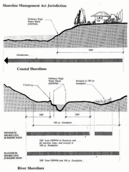
ii. The total area of the shoreline buffer shall be the equivalent of the length of the property along the shoreline, multiplied by the required buffer depth as prescribed for the specific shoreline designation in which the property is located. See Figure 16.12.030-1.
iii. The shoreline buffer consists of two zones. The depth of each of the two zones within the shoreline buffer is determined as follows:
(A) Zone 1 shall extend from the ordinary high water mark (OHWM) a minimum of 30 feet, or to the limit of existing native vegetation whichever is greater. The native vegetation limit is determined through a site-specific analysis of existing conditions, and in no case shall Zone 1 be greater than the depth of the shoreline buffer.
(B) Zone 2 shall be established immediately landward of Zone 1 and extend no further than the depth of the shoreline buffer.
iv. The following zone-specific planting regulations apply to the shoreline buffer:
(A) New lawns are not permitted in Zone 1.
(B) In Zone 2, one-third of the area may be planted in a combination of grass lawns and approved structures, provided:
(1) Significant native trees are not removed to establish such use; or
(2) The buffer has been reduced through view provisions of subsection B.3.i of this section.
(C) The remaining two-thirds of Zone 2 shall be maintained in a native vegetative state.
(D) Planted areas in which fertilizers might be applied shall be located as far landward of Zone 1 as feasible.

Figure 16.12.030-1 Dual Shoreline Buffer
e. Regulations – General Vegetation Alterations in Shoreline Buffers or Site-Specific Vegetation Management Areas.
i. The following activities are allowed within the shoreline buffer and site-specific vegetation management area with an approved clearing permit. Such activities shall meet the standards of subsection B.4 of this section, Land Modification.
(A) Existing landscape areas may be retained within the shoreline buffer or site-specific vegetation management area. However, any changes from the existing landscape to a different landscaping use or activity will require that the modified area comply with the provisions of subsection B.3 of this section, Vegetation Management, and the intent of providing native vegetation to maintain ecological functions and processes.
(B) Minor Pruning. Tree pruning, including thinning of lateral branches to enhance views, or trimming, shaping, thinning or pruning necessary for plant health and growth and which does not harm the plant, is allowed consistent with the following standards:
(1) All pruning shall meet the American National Standard Institute (ANSI) tree pruning standards;
(2) In no circumstance shall removal of more than one-fourth of the original crown be permitted within a three-year period;
(3) Pruning shall not include topping, stripping of branches or creation of an imbalanced canopy; and
(4) Pruning shall retain branches that overhang the water.
(C) Vegetation Removal Related to Construction. Tree or vegetation removal within the shoreline buffer or site-specific vegetation management area that is associated with new construction may be allowed, but must retain significant trees and shall meet the requirements of subsection B.2 of this section, Environmental Impacts, including replanting provisions.
(D) Vegetation Removal Related to Public Facility Maintenance. Tree or vegetation removal within the shoreline buffer or site-specific vegetation management area that is associated with maintenance of existing public facilities (including: roads, paths, bicycle ways, trails, bridges, sewer infrastructure facilities, storm drainage facilities, fire hydrants, water meters, pumping stations, street furniture, potable water facilities, and other similar public infrastructure), may be approved by the administrator if no significant trees are removed, the requirements of subsection B.2 of this section, Environmental Impacts, are met, and the maintenance measures meet the goals and policies of subsection B.3 of this section, Vegetation Management, or as approved in a SOP manual as provided in subsection B.3.c.vii of this section. The following activities are exempt from this requirement:
(1) Removal of vegetative obstructions required for sight distance and visual clearance at street intersections provided in the Public Works Design and Construction Standards and Specifications.
(E) Underground Utilities. Utilities that run approximately perpendicular to the buffer (for example, a stormwater tightline to the water to protect a slope or a sewer line to a marina) may be allowed within the shoreline buffer or site-specific vegetation management area; provided, that disturbance is minimized and the disturbed area is revegetated after construction; and
(F) Other Approved Development in the Shoreline Buffer or Site-Specific Vegetation Management Area.
(1) Potable water wells; and
(2) Approved shoreline stabilization.
ii. Shoreline Buffer Reductions.
(A) When the prescriptive buffer depth is reduced or dimensions altered through provisions of this program, the applicant shall record a notice on title, or other similar document, with the county auditor prior to permit issuance, subject to the approval of the administrator.
(B) If the required depth of a shoreline buffer for a single-family residential property is reduced in accordance with the shoreline structure setback provisions of subsection B.3.i of this section or other reductions allowed through this program, Zone 1 must be restored in accordance with provisions of subsection B.2.c of this section.
iii. Stairways to the shoreline shall not exceed 300 square feet for private use, the minimum necessary for public use and are not included in the total square footage allocations prescribed in subsection B.3.f.ii of this section.
(A) A larger stairway serving a single-family residence may only be allowed through approval of a shoreline variance.
(1) As an alternative to a stairway larger than 300 square feet and to reduce environmental impacts, a tram may be allowed without a variance.
(B) Stairway design shall meet the following minimum criteria:
(1) International Codes for:
(a) Hand railings;
(b) Stairway width; and
(c) Tread depth.
(2) Landings are required, unless demonstrated not to be necessary, and shall be determined by:
(a) Existing site topography;
(b) Personal safety; and
(c) Slope stability.
f. Vegetation Alterations Standards – Residential Development. Minor clearing, grading or construction may be allowed within the shoreline buffer or site-specific vegetation management plan for a residential development with approval of the administrator pursuant to subsection B.3.e.i.A of this section, and only for the following activities as prescribed below and pursuant to subsection B.4 of this section, Land Modification:
i. Maintenance of existing residential landscaping is allowed subject to subsections B.3.c.viii and e.ii of this section. One hand installed pervious trail to the shoreline not more than four feet in width, which may include hand installed steps, and shall be designed to minimize environmental impacts. No significant trees shall be removed. The trail may be wider when required for handicapped or public access. For single-family residential development vegetation trimming is limited to two feet on either side of the trail.
ii. Nonhabitable structures appurtenant to a single-family use, such as a boat house, deck/patio and/or stairway, may be allowed consistent with the following standards, except that all structures are prohibited in Zone 1 when upland of a priority aquatic – Category A designation.
(A) For site-specific vegetation management areas, the total square footage of all buildings or structures must not exceed 300 square feet in area.
(B) For shoreline buffer areas, the total square footage of all buildings or structures must not exceed 400 square feet or 10 percent of the shoreline buffer area, whichever is less.
(C) For shoreline buffer areas, only 10 percent of the total allowed square footage or 300 square feet, whichever is less, can be located in Zone 1, except when upland of priority aquatic B, the total allowable square footage is five percent of Zone 1 or 150 square feet, whichever is less.
(D) All structures must be designed to not significantly impact views from adjoining property primary buildings.
(E) All structures must meet the following standards:
(1) Only water-related structures are allowed within 30 feet of the OHWM or in Zone 1, including a boathouse, permeable deck, boat storage, or staircase.
(2) Shall not exceed 12 feet in height above existing grade.
(3) Decks and/or patios shall be permeable and shall not exceed 30 inches in height above existing grade.
iii. View Maintenance – Single-Family Residential Only. Shoreline residential use and development shall use all feasible techniques to maximize retention of existing native shoreline vegetation within the shoreline buffer and the site-specific vegetation management area.
(A) Limited removal of existing trees or vegetation located on the same property as a single-family residence may be allowed for maintenance of a preexisting view from the primary structure, or to establish a view for a new primary structure, provided the following are met:
(1) The applicant demonstrates to the satisfaction of the administrator that the vegetation removal is the minimum necessary to reestablish or establish a view of the water similar to that enjoyed by other residences in the area and that pruning methods are not sufficient to provide an adequate view of the water similar to that enjoyed by other residences in the area; and
(2) Existing significant native trees are not removed within the shoreline jurisdiction, unless exempt; and
(3) In no instance, including accounting for other approved alterations as provided in subsection B.3 of this section, shall vegetation removal exceed 20 percent of the required shoreline buffer area or site-specific vegetation management area or reduce the vegetation canopy coverage to less than 65 percent in the shoreline buffer or vegetation management area.
(a) Vegetation removal occurring adjacent to the shoreline shall also be limited to 15 linear feet of the water frontage; and
(4) Documentation of compliance with the development standards in subsection B.5.k of this section provided by a licensed geotechnical engineer for any vegetation alteration in a geologically hazardous area. The cost and preparation of the plan is the responsibility of the applicant; and
(5) All vegetation removal complies with other applicable requirements of this program (such as clearing and grading, forest practices, and protection standards for fish and wildlife habitat), including the no net loss and/or revegetation standards in subsection B.2 of this section.
(B) The administrator may deny a request or condition approval for vegetation alteration proposals for view maintenance if it is determined that the action will result in an adverse effect to any of the following:
(1) Slope stability;
(2) Habitat value;
(3) Health of surrounding vegetation;
(4) Risk of wind damage to surrounding vegetation;
(5) Nearby surface or groundwater; or
(6) Water quality of a nearby water body.
g. Vegetation Alteration Standards – Commercial and Industrial Development in Shoreline Buffers. Minor clearing, grading, or construction may be approved within the shoreline buffer for a commercial or industrial development with approval of the administrator pursuant to subsection B.3.e.i.A of this section and only for the following activities as prescribed below and pursuant to subsection B.4 of this section, Land Modification:
i. Primary appurtenant structures to a commercial use that either support public access or are necessary to support a water-dependent use shall be allowed within the buffer when the applicant has demonstrated a need for the shoreline location, except that all structures are prohibited in Zone 1 when upland of a priority aquatic designation.
ii. When appurtenant structures are allowed they must be the minimum necessary to meet the needs of the water-dependent use or public access requirements of subsection C.4 of this section, Public Access – Visual and Physical.
h. Vegetation Alteration Standards – Public Park Development in Shoreline Buffers. Minor clearing, grading, or construction may be allowed within the shoreline buffer for a public park development with approval of the administrator consistent with the following or pursuant to subsection B.3.e of this section:
i. Vegetation clearing and maintenance is allowed in accordance with an approved SOP manual that meets subsection B.3.c.vii of this section and the standards of this program.
ii. Maintenance of existing public trails, provided the vegetation trimming is limited to two feet on either side of the trail and no significant trees are removed.
iii. Alterations that are included in a park development or concept plan. Minor clearing, grading, or construction for which the size and extent of proposed disturbed areas located within the shoreline buffer have been determined as part of a park development plan or concept park plan, with due consideration of the intended park use; and provided all proposed disturbance areas meet the no net loss standards pursuant to and in accordance with subsection B.2 of this section, Environmental Impacts; and provided appropriate permits are obtained, including those pursuant to subsection B.4 of this section, Land Modification.
iv. Alterations that are not part of a park development or concept plan. The following minor clearing, grading, or construction activities may be allowed without an approved park development plan or conceptual park plan:
(A) Maintenance of existing public trails is allowed, provided maintenance is limited to the existing size of the trail, any vegetation trimming is limited to four feet on either side of the trail, and no significant trees are removed.
(B) New public pathways or trails to the shoreline, provided it is demonstrated that the size and extent of the public pathways has been determined with due consideration of the intended park use.
(C) Structures.
(1) Primary appurtenant structures to a public park and recreational use that either support public access or are necessary to support a water-dependent recreation use shall be allowed within the shoreline buffer when a need for the shoreline location is demonstrated, except that all structures are prohibited in Zone 1 when upland of a priority aquatic designation. When appurtenant structures are allowed, they must be the minimum necessary to meet the needs of the water-dependent use or public access requirements of subsection C.4 of this section, Public Access – Visual and Physical.
(2) The total square footage of all buildings or structures must not exceed 6,000 square feet or 10 percent of the shoreline buffer area, whichever is less.
(a) Only 10 percent of the total allowed square footage or 1,000 square feet, whichever is less, can be located in Zone 1.
(3) All structures must be designated to not significantly impact views from adjoining property primary buildings.
(4) All structures must meet the following standards:
(a) Only water-related recreational furniture, amenities and structures are allowed in Zone 1, including but not limited to picnic tables, benches, interpretive kiosks, viewing platforms, boardwalks, pervious trails or staircases; recreational furniture, signs, pervious trails, and staircases are not included in the maximum square footage allocations prescribed in subsection B.3.h.iv.C.2 of this section;
(b) Accessory recreation buildings, including restrooms, picnic pavilions and service roads that serve such structures, may be allowed in Zone 2 and buildings shall not exceed 12 feet in height above existing grade;
(c) Stairways may exceed 300 square feet; provided, that it is demonstrated that a greater area is necessary to meet public access and public use demands. Stairways shall conform to the standards of the building code as adopted in Chapter 15.04 BIMC; and
(d) Boat ramps and other boating facilities may be allowed pursuant to BIMC 16.12.040.C, Boating Facilities.
i. Regulations – Shoreline Structure Setback View Requirement.
i. To protect existing predominate shoreline views and accommodate shoreline views for a new single-family primary residential structure or addition to a primary residential structure, the administrator may allow Zone 2 of the shoreline buffer to be altered when there is an existing primary residential structure located within 100 feet of the property line of the subject property and topographical or other relevant information indicates that the view of the shoreline from the subject property or the adjacent residence would be impacted by existing or proposed development. The shoreline structure setback line may also require that new structures be set farther away from the shoreline to preserve existing views enjoyed by an adjoining single-family primary structure that was established earlier. These provisions apply to single-family residences only, except in the Point Monroe District.
(A) Setbacks for the purpose of this subsection are based on the location of primary residential structure(s) existing at the time a new primary residential building permit is submitted. A primary residential structure constructed in compliance with the required shoreline setback is not made nonconforming by the later construction of a primary residential structure in a different location on an adjoining lot.
(B) The shoreline structure setback provisions apply only to primary single-family residential structures located within the 200-foot shoreline jurisdiction, where an existing primary single-family residential structure is located within 100 feet of the subject property line. All measurements are to the closest primary residential structure on either side of the subject property as measured parallel to the shoreline.
(C) In determining the shoreline structure setback line, the administrator may also consider topography or other physical property constraints in addition to the provisions of subsections B.3.i.iv and v of this section. Applicants may submit detailed information regarding how property constraints impact the predominant shoreline views from either the subject property’s proposed primary residential structure or adjoining properties’ primary residential structure(s).
ii. The shoreline buffer on the subject property may be reduced below the depth requirements identified in Table 16.12.030-3 to allow a new primary residential structure to be located within Zone 2, provided the conditions in subsection B.3.e.ii of this section are met. Mitigation of proposed residential development shall be required pursuant to subsection B.2 of this section, Environmental Impacts.
iii. In no case shall the subject property be permitted to locate a new primary residential structure within the site’s specified Zone 1 of the shoreline buffer, unless a shoreline variance is granted.
iv. Adjoining Development Located Within Shoreline Buffer. The setback requirement for the subject property shall be based on the location of the adjoining properties’ primary residential structure(s) as described in subsections B.3.i.iv.A through C of this section:
(A) Primary Residential Structure Located on One Side. When an existing primary residential structure is located on one side of the subject property, the shoreline structure setback line shall be determined as follows:
(1) If the adjoining primary residence is partially or wholly located within Zone 2, the shoreline setback line is determined by drawing a line from the most waterward point of the adjoining primary residential structure to the point at which the subject property’s shoreline buffer boundary intersects the subject property’s opposite property line. (See Figure 16.12.030-2 below.)
(2) If the adjoining primary residence is located partially or wholly in Zone 1, the shoreline structure setback line shall be determined by drawing a line from the point of intersection of the subject property and the adjoining property’s Zone 1 boundary, to the point at which the subject property’s shoreline buffer boundary intersects the subject property’s opposite property line. (See Figure 16.12.030-3 below.)
(B) Primary Residential Structure Located on Both Sides. When existing primary residential structures are located on both sides of the subject property, the shoreline structure setback line shall be determined as follows:
(1) If both the adjoining primary residential structures are located partially or wholly in Zone 2, then the shoreline structure setback line shall be determined by drawing a line between the most waterward points of each of the adjoining primary residential structures. (See Figure 16.12.030-4 below.)
(2) If one of the adjoining primary residences is partially or wholly in Zone 1, and the other adjoining primary residence is partially or wholly in Zone 2, the shoreline structure setback line shall be determined by drawing a line from the point of intersection of the subject property and the adjoining property’s Zone 1 boundary (for that adjoining residence located in Zone 1), to the most waterward point of the other adjoining primary residential structure located in Zone 2. (See Figure 16.12.030-5 below.)
(3) If both of the adjoining primary residences are located partially or wholly within Zone 1, the shoreline structure setback line shall be determined by drawing a line from the point of intersection of the subject property’s Zone 1 boundary and the adjoining property’s Zone 1 boundary to the same intersection point on the subject property’s opposite property line. (See Figure 16.12.030-6 below.)
(C) Primary Residential Structure Located on a Shoreline Forming a Cove or Headland. The administrator shall make the determination whether a shoreline forms a cove or headland. When existing primary residential structures are located on a cove or headland, the shoreline structure setback line shall be determined as follows:
(1) If there is a primary residential structure on only one side of the subject property, then the shoreline structure setback line for the subject property shall be either the distance from the OHWM to the most waterward portion of the primary residence structure of the adjoining property, or the subject property’s Zone 1, whichever is greater. (See Figure 16.12.030-7 below.)
(2) If there are adjoining primary residential structures located on both sides of the subject property, the shoreline structure setback line shall be determined by averaging the distance from the OHWM to the most waterward portion of the two adjoining property’s primary residential structures. (See Figure 16.12.030-8 below.)
v. Adjoining Development Located Outside the Shoreline Buffer. The setback requirement for the subject property shall be based on the location of the adjoining properties’ primary residential structure(s) as described in subsections B.3.i.v.A and B of this section:
(A) Primary Structure Located on One Adjoining Property, Outside Shoreline Buffer. When an existing primary residential structure is located on one side of the subject property, the shoreline structure setback line shall be determined by drawing a line from the most waterward point of the primary residential structure of the adjoining property to a point at which the subject property’s shoreline buffer boundary intersects the subject property’s opposite property line. (See Figure 16.12.030-9 below.)
(B) Primary Structures Located on Both Adjoining Properties, Outside the Shoreline Buffer. When existing primary residential structures are located on both sides of the subject property, the shoreline structure setback line shall be determined by drawing a line between the most waterward points of each of the adjoining primary residential structures. (See Figure 16.12.030-10 below.)
(C) Primary Structures Located on Both Adjoining Properties, Outside the Shoreline on a Cove or Headland. When existing primary residential structures are located on both sides of the subject property, the shoreline structure setback line shall be determined by averaging the distance from the OHWM to the most waterward portion of the two adjoining property’s primary residential structures. (See Figure 16.12.030-11 below.)
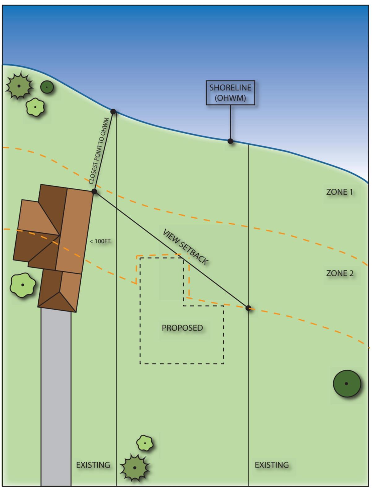
Figure 16.12.030-2
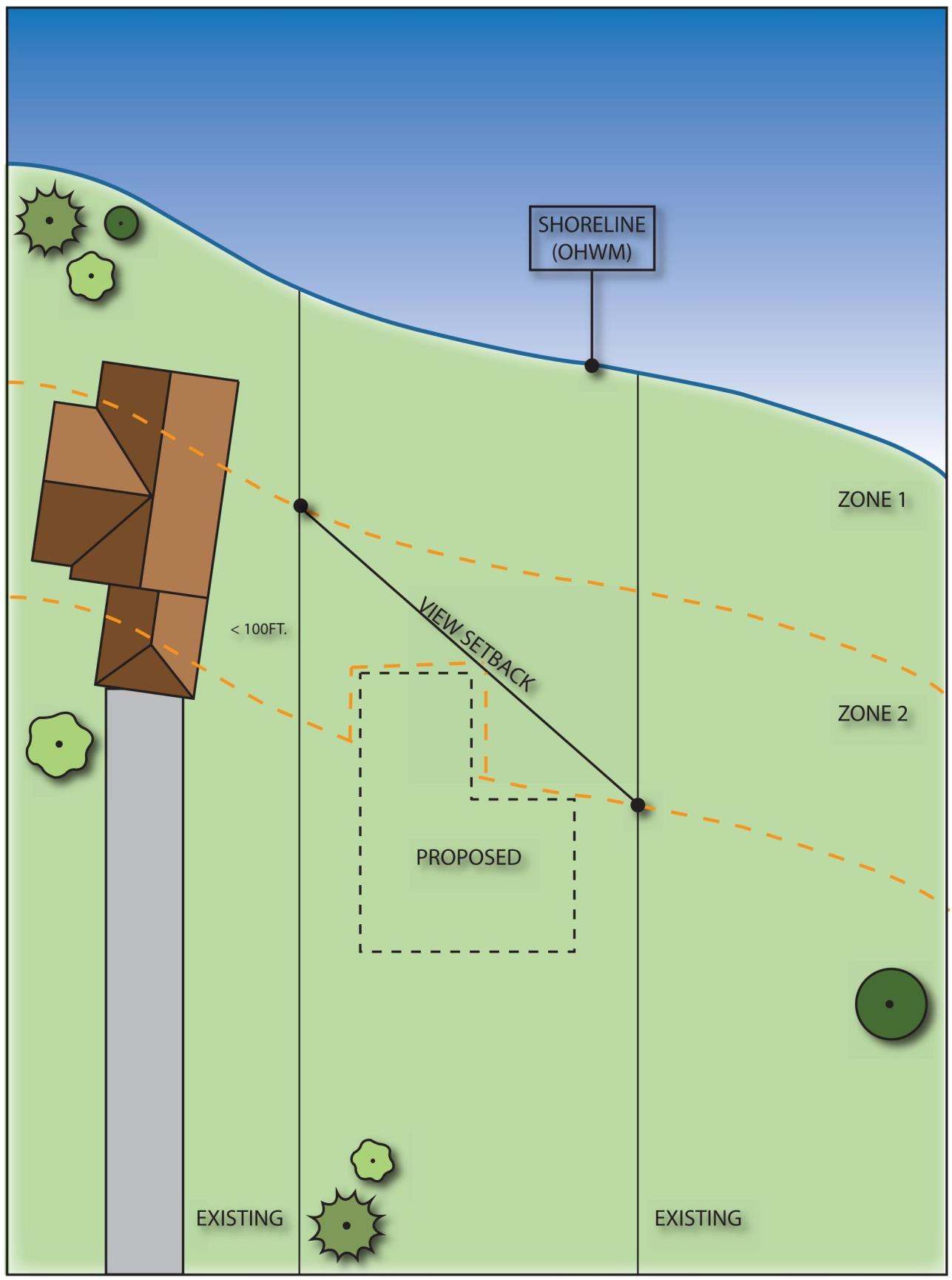
Figure 16.12.030-3
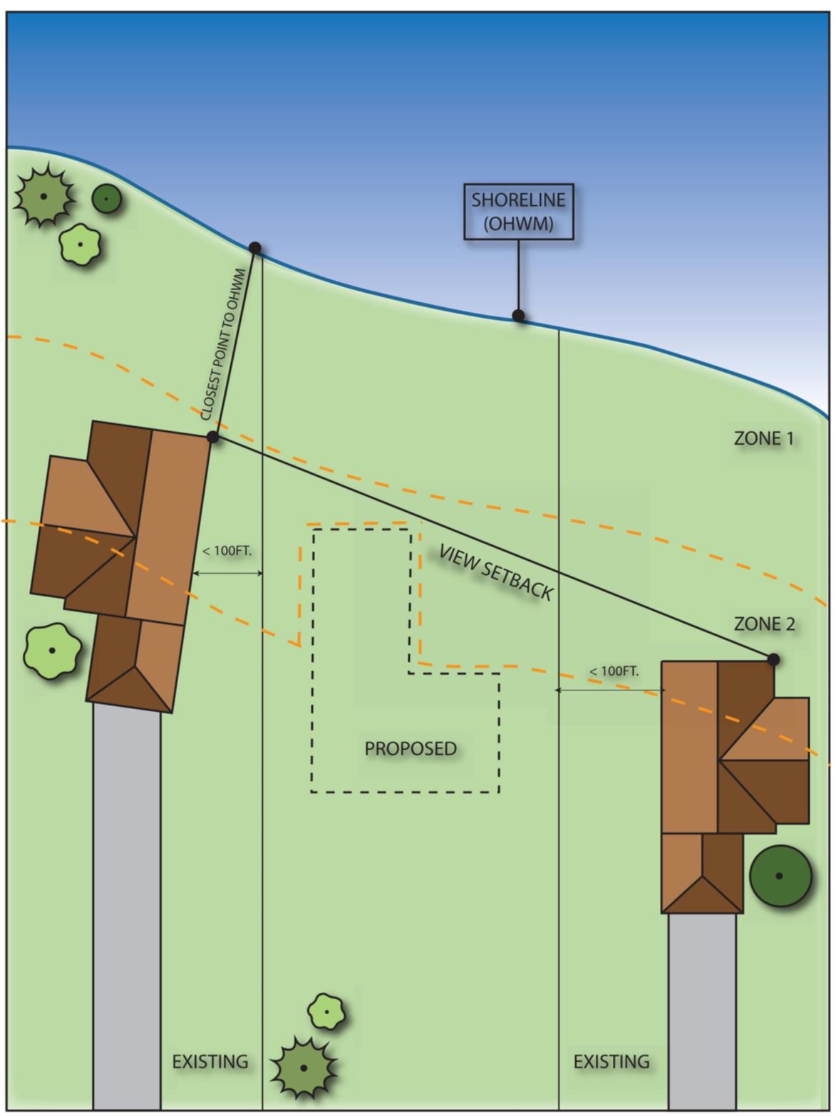
Figure 16.12.030-4
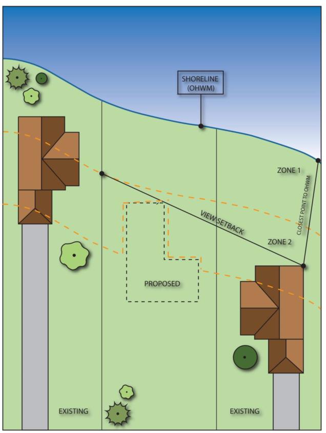
Figure 16.12.030-5
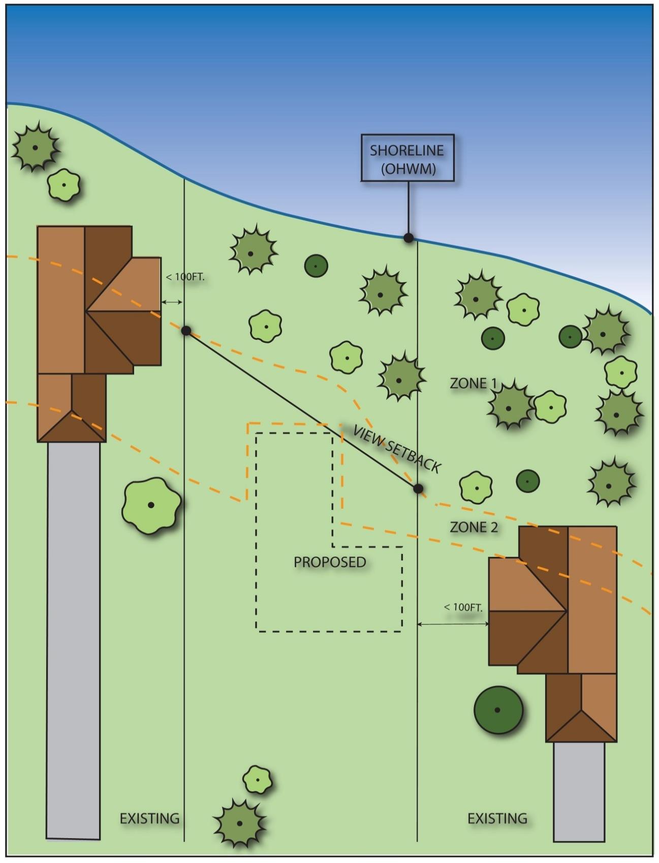
Figure 16.12.030-6
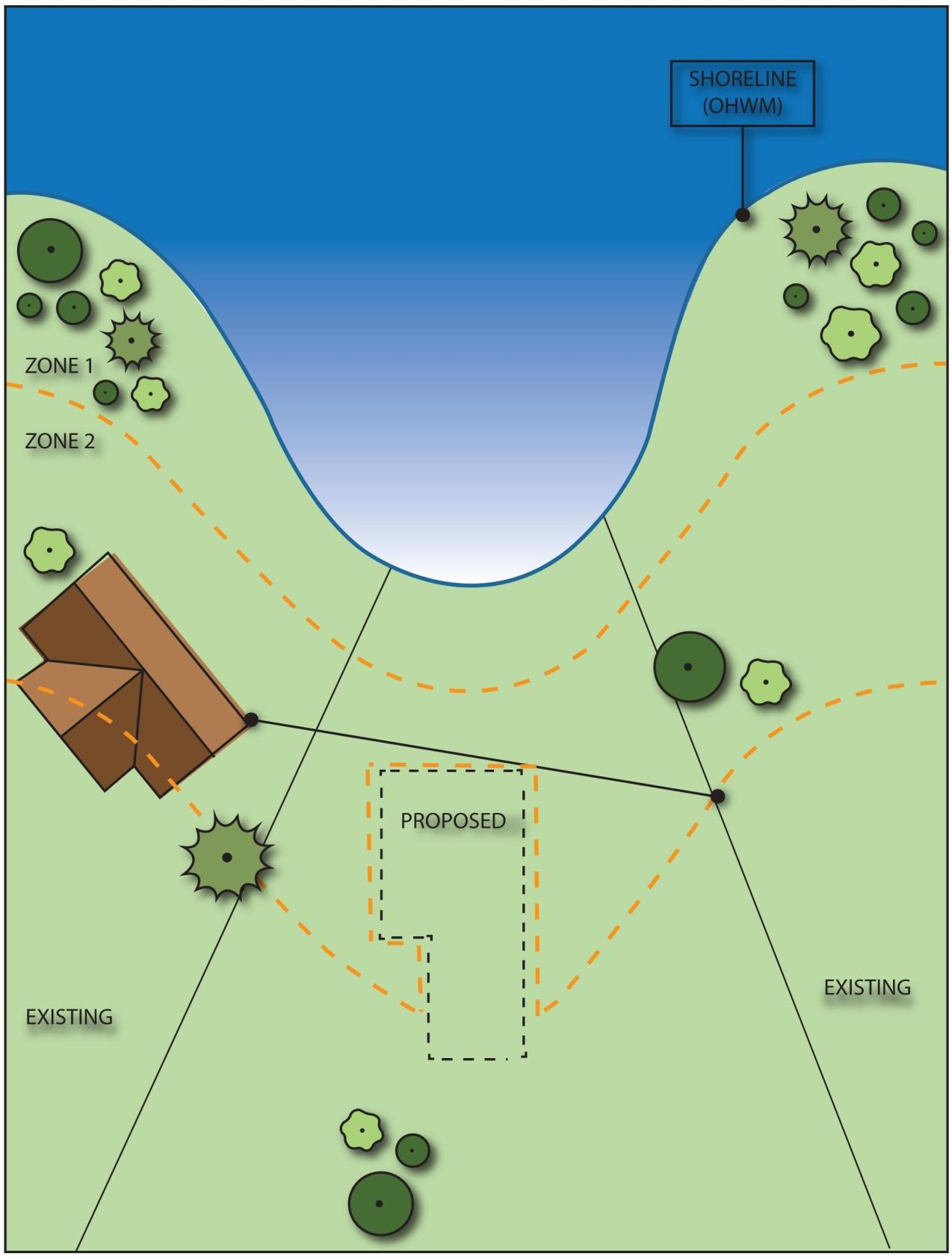
Figure 16.12.030-7
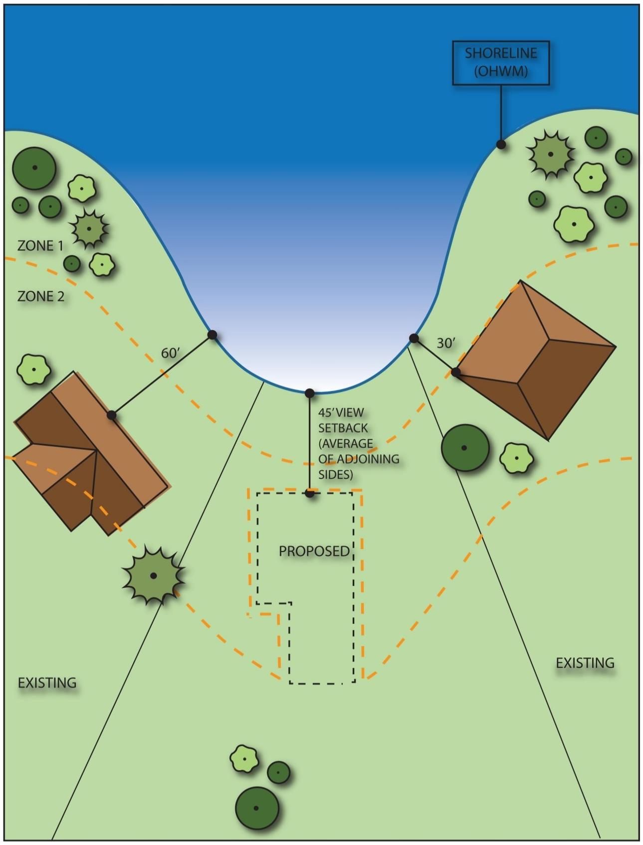
Figure 16.12.030-8
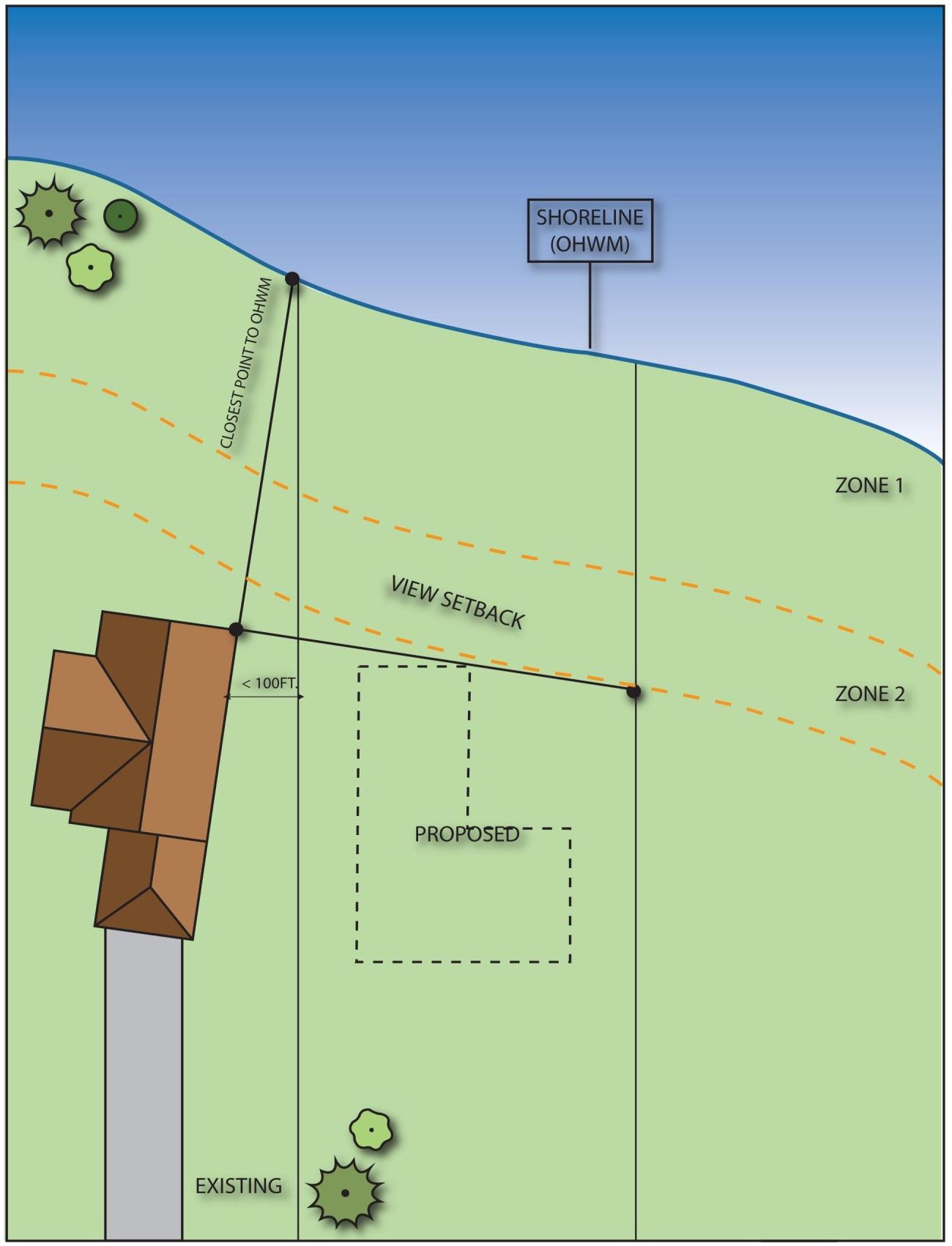
Figure 16.12.030-9
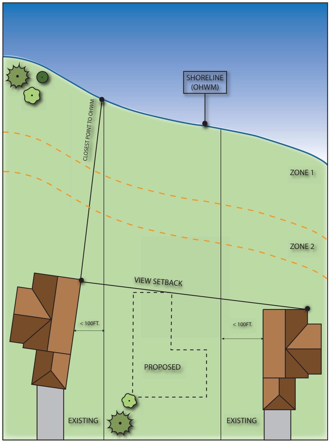
Figure 16.12.030-10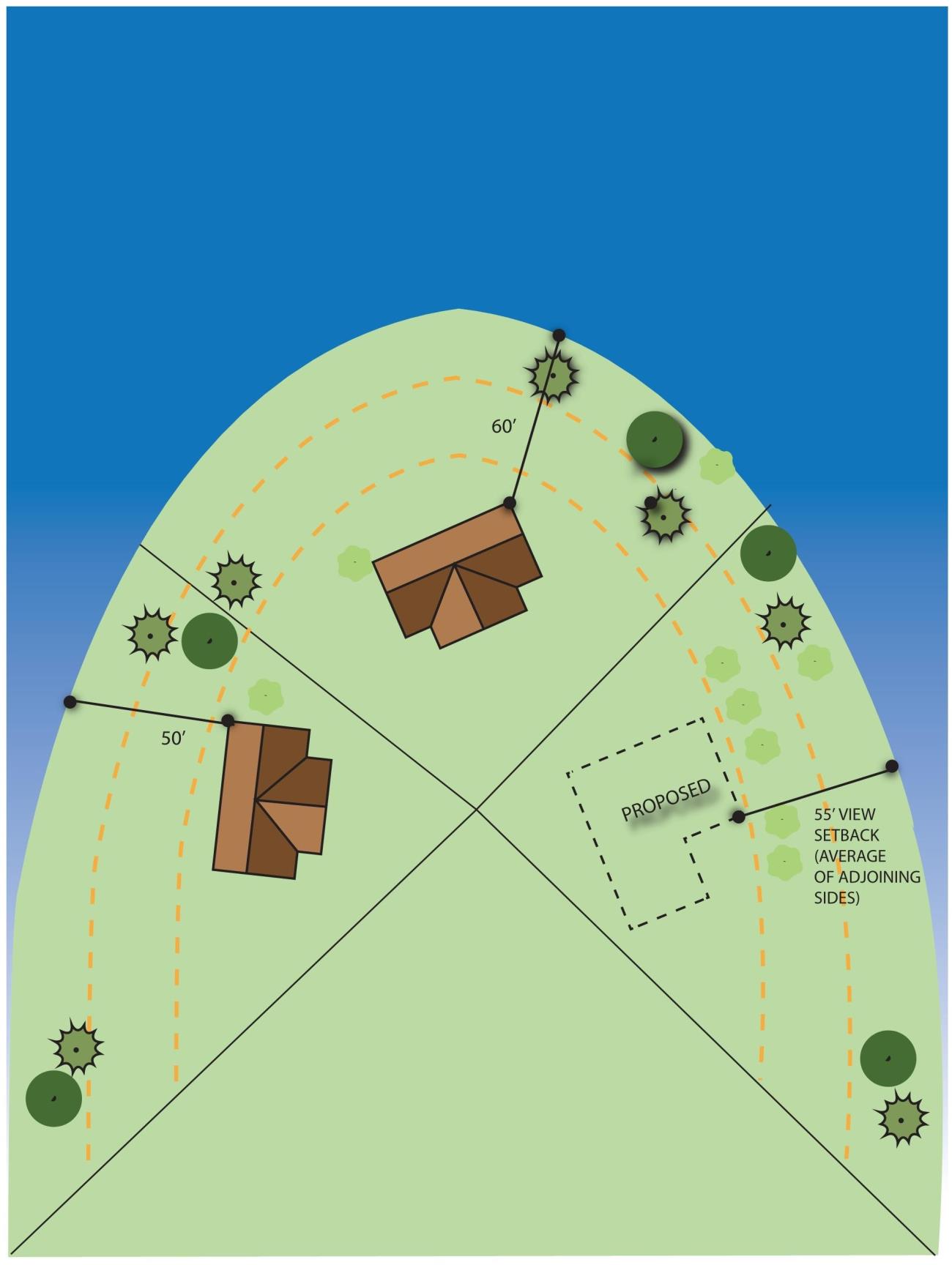
Figure 16.12.030-11
4. Land Modification.
a. Applicability. All shoreline uses and activities must conform to the clearing and grading provisions herein, including development which does not require a shoreline permit. Shoreline development and land modification activities will be reviewed under the no net loss provisions of subsection B.2 of this section, Environmental Impacts, and may also be reviewed under subsection A of this section, Regulations – General; subsection B.3 of this section, Vegetation Management; subsection B.5 of this section, Critical Areas; subsection B.6 of this section, Water Quality and Stormwater Management; and Chapter 15.18 BIMC, Land Clearing, when applicable. Other portions of this program may also apply.
b. Regulations – Prohibited.
i. All clearing and/or grading not associated with an approved development, use or activity, unless specifically provided for in this program.
c. Regulations – General.
i. Clearing and/or grading within shoreline jurisdiction shall require an approved clearing or grading permit in association with an existing legal use or a new permitted or allowed shoreline use or development. Such activities shall meet the mitigation and revegetation provisions in subsection B.2 of this section, Environmental Impacts, and subsection B.3 of this section, Vegetation Management.
ii. Upon completion of development, use or activity, the remaining cleared areas shall be replanted within the first applicable planting season.
iii. All vegetation that is intended to be retained but may likely be disturbed by the clearing and grading activity shall be protected in accordance with the standards of BIMC 18.15.010, Landscaping, screening, and tree retention, protection and replacement.
iv. Land alteration (clearing, grading, and filling) shall be limited to the minimum extent necessary for the proposed development, use or activity. All land alteration must meet the standards of Chapter 15.20 BIMC, Surface and Stormwater Management.
5. Critical Areas.
a. Applicability. This section provides policies and regulations that apply to critical areas located within the shoreline jurisdiction, including wetlands, streams, geologically hazardous areas, frequently flooded areas, fish and wildlife habitat conservation areas, and critical saltwater habitat. This section applies to all development, uses and activities within areas or adjacent to areas designated as critical areas. No action shall be taken by any person, company, agency, governmental body (including the city), or applicant, which results in any alteration of a critical area except as consistent with the goals, policies, purposes, intent, requirements, and development standards of this section.
b. Goal. Comprehensively manage shoreline uses and activities to protect, enhance, and restore existing ecological functions and ecosystem-wide processes of critical areas by utilizing the most current, accurate, and complete scientific and technical information. By avoiding and limiting adverse impacts to and alteration of critical areas, this section seeks to protect the Island’s special character and accomplish the following goals:
i. Conserve the biodiversity of plant and animal species, protect, maintain and restore healthy, functioning ecosystems through the protection of unique, fragile, and valuable elements of the environment, including, but not limited to, ground and surface waters, wetlands, fish and wildlife and their habitats;
ii. Direct development, uses and activities to less environmentally sensitive sites and mitigate unavoidable impacts to critical areas by regulating alterations in and adjacent to critical areas;
iii. Prevent cumulative adverse environmental impacts to water quality, water quantity, wetlands, and fish and wildlife habitat, and the overall net loss of wetlands, frequently flooded areas, aquifer recharge, and habitat conservation areas;
iv. Protect members of the public and public resources and facilities from injury, loss of life, or property damage due to landslides and steep slope failures, erosion, seismic events, or flooding; and
v. Alert owners, potential purchasers, real estate agents, appraisers, lenders, builders, developers and other members of the public to natural conditions that pose a hazard or otherwise limit development.
c. Purpose and Intent.
i. The purpose of this section is to designate and classify ecologically sensitive and hazardous areas as critical areas and to protect, maintain and restore these areas and achieve no net loss of their functions and values.
ii. This section is intended to implement the goals, policies, guidelines, and requirements of the city comprehensive plan and the Shoreline Management Act (Chapter 90.58 RCW).
iii. Critical areas provide a variety of valuable and beneficial biological and physical functions that benefit the city and its residents. Critical areas may also pose a threat to human safety or to public and private property. The beneficial functions and values provided by critical areas include, but are not limited to, water quality protection and enhancement, fish and wildlife habitat, food chain support, flood storage, conveyance and attenuation of flood waters, groundwater recharge and discharge, erosion control, wave attenuation, and protection from hazards and the impacts of climate change. Groundwater recharge is of particular concern for the city because the Island’s drinking water is supplied solely by groundwater.
iv. This section is to be administered with flexibility and attention to site-specific characteristics. It is not the intent of this section to make a parcel of property unusable by denying its owner reasonable use of the property or to prevent the provision of public facilities and services necessary to support existing development. If the provision of this chapter results in the denial of reasonable use of a property, relief can be sought through the shoreline variance permit process.
d. Protection of Critical Areas.
i. All proposed development, uses, and activities subject to this section shall utilize mitigation sequencing pursuant to subsection B.2.d of this section.
ii. The precautionary principle shall be applied in the review of any action, taken or proposed, that does not conform to the requirements of this section. The burden of proof that the action will cause no net loss or harm to persons or property falls on the applicant or the property owner.
e. Policies.
i. Provide a level of protection to critical areas that protects, maintains and restores these areas, and achieves no net loss of their functions and values.
ii. Encourage development proposals to include elements of preservation, conservation, restoration, or enhancement of critical areas, including saltwater habitat and fish and wildlife conservation areas, through incentives and ecosystem-wide restoration planning.
iii. Locate, design, construct, and manage all shoreline uses and activities in ways that assure no net loss of shoreline ecological functions and ecosystem-wide processes, and protect critical saltwater habitat, including fish and wildlife habitat conservation areas.
iv. Locate and design shoreline uses, activities, and/or development to avoid risks to people and property. See also BIMC 16.12.020, Shoreline designation regulations, for additional provisions.
v. Promote water-related shoreline uses and activities, such as public access and recreation, that are compatible with critical areas, provided they do not result in a net loss of critical area functions and values.
f. Allowed Activities Within Critical Areas.
i. The following activities are allowed within critical areas and their buffers and do not require review for compliance with critical area regulations. Any activity not subject to critical areas regulations that constitutes development pursuant to BIMC 16.12.080, Definitions, is subject to applicable review under this program.
(A) Normal and routine yard and garden activities including, but not limited to, cutting and mowing lawns, weeding, removal of noxious and invasive species, harvesting and replanting of garden plants and crops, incidental vegetable gardening, and pruning and planting of noninvasive ornamental vegetation, intended to maintain the general condition and extent of such areas; provided, that such activities are limited to legally existing yard and garden areas, do not further expand into critical areas or associated buffers, do not significantly alter topography, and do not diminish water quality or quantity. Normal and routine activities cannot result in a change to the location, size at the ground level or configuration of existing yard and garden areas.
(B) Class I, II and III forest practices regulated pursuant to Chapter 76.09 RCW.
(C) Minor Site Investigative Work. Work necessary for land use review submittals, such as surveys, soil logs, percolation tests, and other related activities, where such activities do not require a clearing permit pursuant to subsection B.4 of this section or construction of new roads. In every case, impacts to the critical area shall be minimized and disturbed areas shall be immediately restored. Minor site investigative work may include educational and scientific research activities.
(D) Activities Within the Improved Right-of-Way. Replacement, modification, installation, or construction of utility facilities, lines, pipes, mains, equipment, or appurtenances, when such facilities are located within the improved portion of the public right-of-way or easement of a private street, except those activities that alter a wetland or watercourse, such as culverts or bridges, or result in the transport of sediment or increased stormwater.
(E) The installation of low impact fencing within critical area buffers, provided the location does not result in restricting wildlife movement, the location and installation is the least impactful to the critical area and buffer as possible, and there is no alternative to fencing to achieve the purpose of the fence.
(F) Signs for marking critical area boundaries, interpretive signs and survey markers or property boundaries.
(G) Development, uses or activities within critical aquifer recharge areas that do not have the potential to generate a pollutant identified as a potential source of drinking water contamination pursuant to subsection B.5.i of this section and are outside an aquifer recharge protection area (ARPA) if one has been designated pursuant to BIMC 16.20.100 and any other critical area or its buffer or setback.
ii. The following activities are allowed within critical areas and their buffers, without a shoreline variance, after review and authorization by the city. Review and authorization may occur over-the-counter and will require a written letter of approval or shall be reviewed for consistency with this section as part of the required shoreline review or permit. Any activity not subject to critical areas regulations that constitutes development pursuant to BIMC 16.12.080, Definitions, is subject to applicable review under this program.
(A) Activities within a portion of a wetland buffer or fish and wildlife habitat conservation area buffer separated from the critical area by an existing permanent substantial development, use or activity which serves to eliminate or greatly reduce the impact of the proposed activity on the critical area are exempt from establishing the full required buffer width; provided, that impacts to the critical area do not increase. The director shall review the proposal to determine the likelihood of associated impacts and may require the applicant to provide a critical areas report prepared by a qualified professional that demonstrates through a site assessment or functional analysis that the interrupted buffer area is functionally isolated from the critical area. The director shall consider the hydrologic, geologic, and/or biological habitat connection potential and the extent and permanence of the physical separation.
g. Regulations – General.
i. Any proposed development or activity within a critical area or its buffer or setback requiring review under this program shall be reviewed based on the proposal’s ability to comply with all of the following criteria:
(A) The proposal minimizes the impact on critical areas in accordance with mitigation sequencing (subsection B.2.d of this section);
(B) The proposal does not pose an unreasonable threat to the public health, safety, or welfare on or off the development proposal site;
(C) The proposal is consistent with the general purposes of this section and the public interest;
(D) Any alterations permitted to the critical area are mitigated in accordance with mitigation requirements in subsection B.2.d of this section;
(E) The proposal protects the critical area functions and values consistent with best available science and results in no net loss of critical area functions and values;
(F) The proposal addresses cumulative impacts of the action; and
(G) The proposal is consistent with other applicable regulations and standards.
ii. The city may condition the proposed activity as necessary to mitigate impacts to critical areas and to conform to the standards required by this section.
iii. Except as provided for by this section, any project that cannot adequately mitigate its impacts to critical areas in the sequencing order of preferences in subsection B.2.d of this section shall be denied.
iv. Support Information Requirements. Any application for proposed development or activity requiring review under this program shall include the following:
(A) A site plan drawn to scale identifying locations of critical areas and their buffers, location of proposed development, uses and activities, location and estimated quantity of earthwork and vegetation clearing and location and type of drainage features or infrastructure.
(B) Any critical area report or study required by this section. Such reports or studies shall be prepared by qualified professionals in the area of concern as defined in BIMC 16.12.080, Definitions, and in accordance with the requirements provided in subsection B.5.n of this section, Critical Areas Reports, as follows:
(1) Aquifer recharge study: hydrogeologist;
(2) Geological hazard assessment: engineering geologist; geotechnical engineer, provided that:
(a) An engineering geologist may provide a study, including interpretation, evaluation, analysis, and application of geological information and data and may predict potential or likely changes in types and rates of surficial geologic processes due to proposed changes to a location, provided it does not contain recommended methods for mitigating identified impacts, other than avoidance, structural impacts to, or suitability of civil works; and
(b) Engineering geologists may not provide engineering recommendations or design recommendations, but may contribute to a complete geotechnical report that is co-sealed by a geotechnical engineer;
(3) Stream buffer enhancement plan: biologist with stream ecology expertise; fish or wildlife biologist; a civil engineer may provide studies for drainage, surface and subsurface hydrology, and water quality;
(4) Wetland buffer enhancement plan, wetland critical area report, wetland mitigation plan: wetlands specialist;
(5) Habitat management plans: wildlife biologist and/or fisheries biologist;
(6) The director is authorized to retain experts at the applicant’s expense and request review from other jurisdictional agencies to assist in the review of application materials.
(c) Any additional information determined as relevant by the director.
v. Notice on Title.
(A) The owner of any property with field-verified presence of critical area or buffer on which a development proposal is submitted shall file for record with the Kitsap County auditor a notice approved by the director in a form substantially as set forth in subsection B.5.g.v.B of this section. Such notice shall provide notice in the public record of the presence of a critical area and buffer, the application of this section to the property, and that limitations on actions in or affecting such areas may exist. The applicant shall submit proof that the notice has been filed for record before the city shall approve any development proposal for such site. The notice shall run with the land and failure to provide such notice to any purchaser prior to transferring any interest in the property shall be in violation of this section.
(B) Form of Notice.
Critical Areas and/or Critical Areas Buffer Notice
Legal Description: _______________
Present owner: _________________
NOTICE: This property contains critical areas or their buffers as defined by the City of Bainbridge Island Ordinance No. __________.
The property was the subject of a development proposal for (type of permit) application #_______ filed on _______ (date).
Restrictions on use or alteration of the critical areas or their buffers may exist due to natural conditions of the property and resulting regulations. Review of such application has provided information on the location of critical areas or critical area buffers and restrictions on their use through setback areas. A copy of the plan showing such setback areas and other restrictions or required enhancements is attached hereto.
Signature of owner: ____________
STATE OF WASHINGTON)
COUNTY OF ___________)
On this day personally appeared before me to me known to be the individual(s) described in and who executed the within and foregoing instrument and acknowledged that they signed the same as their free and voluntary act and deed for the uses and purposes therein stated.
Given under my hand and official seal this ___________ day of _________.
NOTARY PUBLIC in and for the state of Washington, residing at _________.
h. Regulations – Critical Saltwater Habitat.
i. Water-dependent development and uses, including marinas, docks, piers, mooring areas, underwater parks, utility crossings, and shoreline modifications, shall not intrude into or be built over critical saltwater habitat unless:
(A) The applicant can show that all of the following criteria can be met:
(1) The use preferences of subsection B.1 of this section shall be utilized for uses in shorelines of statewide significance; and
(2) The need for such a structure is clearly demonstrated and an alternative alignment or location on the property that would avoid impacts to critical saltwater habitats is not feasible or would result in unreasonable and disproportionate cost to accomplish the same general purpose, as demonstrated through an alternatives analysis. The analysis should include, in part, shoreline bathymetry, shoreline features at the site, and substrate composition; and
(3) It can be demonstrated that the project is consistent with the state’s interest in resource protection and species recovery; and
(4) Impacts to critical saltwater habitat functions and processes are mitigated to result in equal or better ecological function; or
(B) The proposal is for private, noncommercial, residential docks for single use, community, or joint use, which may be authorized; provided, that:
(1) Avoidance of impacts to critical saltwater habitats by an alternative alignment or location is not feasible; and
(2) The project, including any required mitigation, will result in no net loss of ecological functions and processes associated with critical saltwater habitat;
(C) New or expanded overwater structures shall be located the greater or most protective of:
(1) A horizontal distance of 25 feet from the outside edge of the structure to native aquatic vegetation attached to or rooted in substrate;
(2) A horizontal distance equal to the maximum distance shade will be cast by the structure and vessel;
(3) A four-foot vertical distance from eelgrass or relevant submerged aquatic vegetation;
(4) A distance the diameter of the turning circle, if the structure is to be utilized for motorized vessels. The turning circle is defined as three and one-half times the length of the longest vessel to use the structure;
(5) Alternative measures that demonstrate no net loss of ecological functions;
(D) For projects within WDFW documented Pacific herring spawning locations, in-water activities that would affect herring spawn should be restricted to WDFW’s approved work window for Bainbridge Island (May 1st through January 14th). For aquaculture projects, the city may consider alternative methods that are contained in federal and/or state aquaculture permits for reducing impacts to herring spawning habitat and other forage fish spawning habitat;
(E) For projects other than commercial aquaculture within WDFW documented sand lance and surf smelt spawning locations, no activities should occur during spawning windows as identified by WDFW. For commercial aquaculture projects within WDFW documented sand lance and surf smelt spawning locations, no harvesting may occur during the surf smelt or sand lance spawning seasons until a spawning survey is conducted. If surf smelt or sand lance spawn are present in the growing area to be harvested or adjacent tidelands, then no harvest activities may occur until the eggs are hatched. Extreme caution should be taken to avoid impact and minimize disturbance of sand lance and surf smelt larvae that are present.
ii. Aquatic herbicide treatments, mechanical removal of vegetation or aquatic pesticide treatments shall not be used on critical saltwater habitats, except for approved habitat restoration or enhancement measures that meet the provisions of subsection B.6 of this section, Water Quality and Stormwater Management.
iii. Sand, gravel or other materials shall not be added or removed from critical saltwater habitat, unless approved as part of a restoration effort or beach nourishment program or as allowed in subsection B.5.h.i of this section.
iv. New outfalls (including stormwater and sewer outfalls) and discharge pipes shall not be located in critical saltwater habitats or areas where outfall or discharge will adversely affect critical saltwater habitat, unless the applicant can show that all of the following can be met:
(A) There is no feasible alternative location for the outfall or pipe; and
(B) The outfall or pipe is placed below the surface of the beach or bed of the water body; and
(C) The discharge point(s) on the outfall or discharge pipe is located so the discharges, including nutrients and flow, do not adversely affect critical saltwater habitats; and
(D) For public sewage outfalls:
(1) The outfall discharges waterward of the intertidal zone.
(2) The disturbed area will be revegetated with native vegetation.
v. The use of existing outfalls shall be maximized to limit the need for additional outfalls, provided the existing outfall meets the standards of this section, or unless an alternatives analysis demonstrates the dispersal is less impacting to the shoreline environment.
vi. Until an inventory of critical saltwater habitat is completed, all overwater and near-shore development shall conduct an inventory of site and adjacent beach sections to assess the presence of critical saltwater habitat and/or functions and processes. The inventory shall occur prior to construction and the methods and extent of the inventory shall be consistent with accepted research methodology. New studies shall be required only when existing information is outdated or does not exist.
i. Regulations – Aquifer Recharge Areas.
i. Classification. Aquifer recharge areas are areas that have a critical recharging effect on groundwater used for potable water supplies and/or that demonstrate a high level of susceptibility or vulnerability to groundwater contamination from land use activities. In accordance with WAC 365-190-100, the entirety of Bainbridge Island is classified as an aquifer recharge area to preserve the volume of recharge available to the aquifer system and to protect groundwater from contamination.
ii. Prohibited Activities and Uses.
(A) The following activities and uses are prohibited within critical aquifer recharge areas due to the probability or potential magnitude of their adverse effects on groundwater:
(1) Landfills. Landfills, including hazardous or dangerous waste, municipal solid waste, special waste, wood waste, and inert and demolition waste landfills;
(2) Underground Injection Wells. Class I, III, and IV wells and subclasses 5F01, 5D03, 5F04, 5W09, 5W10, 5W11, 5W31, 5X13, 5X14, 5X15, 5W20, 5X28, and 5N24 of Class V wells;
(3) Chemical wood preservation and/or treatment facilities;
(4) Storage, Processing, or Disposal of Radioactive Substances. Facilities that store (other than minor sources such as medicinal uses or industrial testing devices), process, or dispose of radioactive substances;
(5) Hazardous liquid transmission pipelines;
(6) Commercial mining and chemical washing of metals, hard rock, sand, and gravel;
(7) Hydrocarbon extraction, reprocessing, refinement, and storage;
(8) Electroplating/metal finishing;
(9) Facilities that treat, store, process, or dispose of hazardous waste; and
(10) Other Prohibited Uses or Activities.
(a) Activities that would significantly reduce the recharge to aquifers currently or potentially used as a potable water source; and
(b) Activities that would significantly reduce the recharge to aquifers that are a source of significant baseflow to a stream.
iii. Development Standards – General. No development, use or activity may exceed water quality standards or otherwise violate the anti-degradation requirements specified in Chapter 173-200 WAC.
j. Regulations – Fish and Wildlife Habitat Conservation Areas.
i. Classification. Fish and wildlife habitat conservation areas include:
(A) Within the city of Bainbridge Island, streams shall include those areas which meet the definitions in BIMC 16.12.080, Definitions. Streams shall be classified in accordance with the Washington Department of Natural Resources water typing system (WAC 222-16-030), which is hereby adopted in its entirety by reference and summarized as follows:
(1) Type F: streams which contain fish habitat pursuant to BIMC 16.12.080, Definitions;
(2) Type Np: perennial nonfish habitat streams; and
(3) Type Ns: seasonal nonfish habitat streams.
(B) Habitats recognized by federal or state agencies for federal- and/or state-listed endangered, threatened, sensitive and candidate/monitored species which presence is documented in maps or databases available to the city of Bainbridge Island.
(C) Areas that contain habitats and species of local importance. Any person may nominate for designation a species or habitat of local importance. Nominations will be processed pursuant to definitions in BIMC 16.12.080, Definitions, and nomination criteria developed by the director.
(D) Biodiversity areas and corridors as defined in the 2008 Washington Department of Fish and Wildlife priority habitat and species list, or as amended.
(E) All areas within the city of Bainbridge Island meeting one or more of the preceding criteria in this section, regardless of any formal identification or mapping, are hereby designated critical areas and are subject to the provisions of this section and shall be managed consistent with the best available science, such as the Washington Department of Fish and Wildlife’s most recent management recommendations for priority habitat and species.
ii. Mapping. The location and extent of all mapped critical areas shown on the city of Bainbridge Island critical area maps are approximate and shall be used as a general guide only. The type, extent and boundaries shall be determined in the field by a qualified professional according to the requirements of this section. The critical area maps are adopted as part of this section and are incorporated herein by this reference. Washington Department of Natural Resources (DNR) and Washington Department of Fish and Wildlife maps are not the only source of data. Any request to change the city’s existing map shall be accompanied by a report from a qualified professional that includes a description of the critical area and a summary of how it meets the definitions in BIMC 16.12.080, Definitions. The inventory and cited resources are to be used as a guide for the city, project applicants, and/or property owners and may be continuously updated as new or altered critical areas are identified.
iii. Development Standards – Stream Buffers.
(A) All designated streams require a buffer pursuant to Table 16.12.030-4. Buffers shall remain as undisturbed or enhanced vegetation areas for the purpose of protecting the integrity, function, and value of stream resources. Any buffer modification proposed shall be through an approved buffer enhancement plan. No uses or activities shall be allowed within the buffer unless allowed by this section. If the buffer has previously been disturbed, the director may require the disturbed buffer area be enhanced, including revegetation with native plant species, pursuant to an approved buffer enhancement plan meeting the requirements of subsection B.5.n.iv of this section. No refuse, including but not limited to household trash, yard waste and commercial/industrial refuse, shall be placed in the buffer.
(B) The required minimum buffers listed in Table 16.12.030-4 are based on the assumption that the buffer is well vegetated with native species appropriate to the site. If the buffer does not consist of vegetation adequate to provide stream protection and buffer functions, the director may require that the buffer be planted to achieve such protection and function.
Table 16.12.030-4: Stream Buffers
(C) Buffer distances shall be measured from the ordinary high water mark (OHWM) or from the top of each bank where the OHWM cannot be identified.
(D) The buffer width shall be increased to include streamside wetlands which provide overflow storage for stormwater, feed water back to the stream during low flow, or provide shelter and food for fish. In braided channels, the ordinary high water mark or top of bank shall be defined to include the entire stream feature.
(E) For streams in ravines outside the mixed use town center with ravine sides 10 feet or greater in height, the buffer width shall be the greater of:
(1) The buffer width required for the stream type; or
(2) A buffer width which extends 25 feet beyond the top of the ravine.
(F) The director may increase buffer widths, up to 50 percent greater than the applicable buffer set in this section for critical areas with known locations of endangered, threatened, or state monitored or priority species for which a habitat management plan indicates a larger buffer is necessary to protect habitat values for such species. Such determination shall be based on site-specific and project-related conditions.
(G) A structure or hard surface setback line of 15 feet is required from the edge of any stream buffer. Minor structural or impervious surface intrusions into the areas of the setback, such as but not limited to fire escapes, open/uncovered porches, landing places, outside walkways, outside stairways, retaining walls, fences and patios, may be permitted if the department determines upon review of an analysis of buffer functions submitted by the applicant, that construction and/or maintenance of such intrusions will not encroach into the stream buffer or adversely impact the stream. The functional analysis shall include a functional methodology supported by best available science. The setback shall be identified on a site plan and filed as an attachment to the notice on title as required by subsection B.5.g.v of this section, Notice on Title.
(H) Modification to buffer widths may be allowed provided the applicant demonstrates the need for modification through mitigation sequencing pursuant to subsection B.2.d of this section.
(1) The width of a required buffer may be averaged if the applicant can demonstrate that averaging can provide equal or greater functions and values as would be provided under the required buffer and all of the following conditions are met:
(a) The total area of buffer after averaging is equal to the area required without averaging.
(b) Averaging does not result in any portion of the buffer being reduced more than 25 percent of its required width.
(2) Any request for buffer modification outlined above shall be reviewed in conjunction with the underlying land use or construction permit. Requests for buffer reduction shall include a buffer enhancement plan prepared by a qualified consultant that meets the requirements of BIMC 16.12.080, Definitions.
(3) The city may request technical review of a buffer enhancement plan from other agencies to ensure consistency with state, federal or tribal management recommendations.
(4) Any other buffer modification, other than noncompensatory enhancement, requires a shoreline variance.
iv. Development Standards – Other Fish and Wildlife Habitat Conservation Areas.
(A) All development, uses and activities within known fish and wildlife habitat conservation areas require submittal and approval of a habitat management plan (HMP) as specified in subsection B.5.n.iii of this section. The HMP shall consider measures to retain and protect the fish and wildlife habitat and shall consider the effects of land use intensity, buffers, setbacks, impervious surfaces, erosion control and retention of existing native vegetation.
(B) In the case of bald eagles, the HMP shall comply with the Federal Bald and Golden Eagle Protection Act (16 U.S.C. 668) to avoid impacting eagles and their habitat.
v. Development Standards – Specific Development, Uses, and Activities. The following development, uses, and activities may be allowed within fish and wildlife habitat conservation areas and their buffers. Any proposal for the following development shall comply with the standards of this section, other applicable sections of this program, and other applicable state, federal and local regulations. The director may require submittal of a habitat management plan unless project impacts are demonstrated to be de minimis through mitigation sequencing pursuant to subsection B.2.d of this section.
(A) Stream Crossings.
(1) Any private or public road or driveway expansion or construction proposed to cross streams classified within this section shall comply with the following minimum development standards. All other state and local regulations regarding water crossing structures shall apply, and the use of the water crossing design guidelines (WDFW, 2013), or as amended, is encouraged.
(a) Bridges or bottomless culverts shall be required for all Type F streams. Other alternatives may be allowed upon (i) submittal of a habitat management plan which demonstrates that other alternatives would not result in significant impacts to the fish and wildlife conservation area and (ii) as determined through the hydraulic project approval (HPA) process administered by the Washington Department of Fish and Wildlife. The plan must demonstrate that fish habitat will not be reduced in area or function;
(b) Crossings shall not occur in fish-bearing streams unless no other feasible crossing site exists. For new development proposals, if existing crossings are determined to adversely impact salmon spawning or passage areas, new or upgraded crossings shall be located as determined necessary through coordination with Washington Department of Fish and Wildlife;
(c) Bridge piers or abutments shall not be placed in either the floodway or between the ordinary high water marks unless no other feasible alternative placement exists;
(d) Crossings shall not diminish flood carrying capacity;
(e) Crossings shall serve multiple properties whenever possible;
(f) Where there is no reasonable alternative to providing a conventional culvert, the culvert shall be the minimum length necessary to accommodate the permitted activity.
(B) Stream Relocations.
(1) Stream relocations may be allowed only for the purpose of flood protection and/or fisheries restoration and only when consistent with a Washington Department of Fish and Wildlife hydraulic project approval (HPA) process and the following minimum performance standards:
(a) The channel, bank, and buffer areas are replanted with native or equivalent vegetation that replicates a natural, undisturbed riparian condition;
(b) For those waters designated as frequently flooded areas pursuant to Chapter 15.16 BIMC, a professional engineer licensed in the state of Washington provides information demonstrating that the equivalent base flood storage volume and function will be maintained; and
(c) Relocated stream channels are designed to meet or exceed the functions and values of the stream to be relocated.
(C) Pesticides, Fertilizers and Herbicides.
(1) No pesticides, herbicides or fertilizers may be used in fish and wildlife conservation areas or their buffers, except those approved by the U.S. Environmental Protection Agency (EPA) and approved under a Washington Department of Ecology water quality modification permit for use in fish and wildlife habitat conservation area environments and applied by a licensed applicator in accordance with the safe application practices on the label.
(D) Land Divisions and Land Use Permits.
(1) All land divisions and land uses proposed on a site that includes fish and wildlife habitat conservation areas shall comply with the following procedures and development standards:
(a) The open water area of lakes, streams, and tidal lands shall not be permitted for use in calculating minimum lot area.
(b) Land division approvals shall be conditioned so that all required buffers are designated as an easement or covenant encumbering the buffer. Such easement or covenant shall be recorded together with the land division and represented on the final plat, short plat or binding site plan.
(c) In order to avoid the creation of nonconforming lots, each new lot shall contain at least one building site that meets the requirements of this section, including buffer requirements for fish and wildlife habitat conservation areas. Each lot must also have access and a sewage disposal system location that are suitable for development that do not adversely impact the fish and wildlife conservation area.
(d) After preliminary approval and prior to final land division approval, the director may require that the common boundary between a required buffer and the adjacent lands be identified using permanent signs. In lieu of signs, alternative methods of buffer identification may be approved when such methods are determined by the director to provide adequate protection to the aquatic buffer.
(E) Utilities.
(1) Placement of utilities within designated fish and wildlife habitat conservation areas may be allowed pursuant to the following standards:
(a) Construction of utilities may be permitted in fish and wildlife conservation area or their buffers, only when no practicable or reasonable alternative location is available and the utility meets the requirements for installation, replacement of vegetation and maintenance outlined below.
(b) Construction of sewer lines or on-site sewage systems may be permitted in fish and wildlife conservation areas or their buffers when the applicant demonstrates it is necessary to meet state and/or local health code requirements; there are no other practicable alternatives available; and construction meets the requirement of this section. Joint use of the sewer utility may be allowed.
(c) New utilities shall not be allowed in fish and wildlife habitat conservation areas with known locations of federal or state listed endangered, threatened or sensitive species, heron rookeries or nesting sites of raptors which are listed as state candidates except in those circumstances where an approved habitat management plan indicates that the utility will not significantly impact the conservation area.
(d) Utility construction and maintenance shall protect the environment of fish and wildlife conservation area and their buffers.
(i) New utilities shall be aligned whenever possible to avoid cutting or root damage to trees greater than 12 inches in diameter at breast height (four and one-half feet) measured on the uphill side.
(ii) Any area of disturbance shall be revegetated with appropriate native or equivalent vegetation at not less than preconstruction vegetation densities or greater, immediately upon completion of construction or as soon thereafter as possible due to seasonal growing constraints. The utility or landowner responsible for installation shall ensure that such vegetation survives.
(iii) Any additional access for maintenance shall be provided wherever possible at specific points rather than by parallel roads. If parallel roads are necessary, they shall be of a minimum width but no greater than 15 feet; and shall be contiguous to the location of the utility corridor on the side away from the conservation area.
(e) Utility maintenance shall include the following measures to protect the environment of regulated fish and wildlife habitat conservation areas:
(i) Utility towers shall not be sandblasted or spray-painted. Lead-based paint is prohibited.
(ii) No pesticides, fertilizers, or herbicides may be used in fish and wildlife habitat conservation areas or their buffers, except those applied by a licensed applicator in accordance with the safe application practices on the label.
(F) Bank Stabilization.
(1) A stream channel and bank may be stabilized when naturally occurring earth movement threatens existing structures (defined as requiring a building permit pursuant to the applicable building code), public improvements, unique natural resources, public health, safety or welfare, or the only feasible access to property and, in the case of streams, when such stabilization results in maintenance of fish and wildlife habitat, flood control, and improved water quality.
(2) Where bank stabilization is determined to be necessary, bioengineering or other nonstructural methods should be the first option for protection. Structural methods, or hard stabilization, may only be utilized where it can be demonstrated by a professional engineer licensed in the state of Washington that an existing primary residential structure or essential public facility cannot be safely maintained without such measures, and that the resulting hard stabilization is the minimum length necessary to provide a stable building area for the structure. The director may require that bank stabilization be designed by a professional engineer licensed in the state of Washington with demonstrated expertise in hydraulic actions of shorelines. Bank stabilization projects may also require a city of Bainbridge Island clearing or grading permit and hydraulic project approval from the Washington Department of Fish and Wildlife.
(3) Nonstructural streambank protective techniques are preferred to bulkheads or other types of streambank armoring. Nonstructural techniques include but are not limited to vegetation plantings and bioengineering.
(G) Fencing and Signs. Prior to approval or issuance of permits for land divisions or other new development, the director may require that the common boundary between a required buffer and the adjacent lands be identified using fencing or permanent signs. In lieu of fencing or signs, alternative methods of buffer identification may be approved when such methods are determined by the director to provide adequate protection for the buffer.
(H) Forest Practice, Class IV General and Conversion Option Harvest Plans (COHPs). All timber harvesting and associated development activity, such as construction of roads, shall comply with the provisions of this chapter, and the stormwater management standards in Chapters 15.20 and 15.21 BIMC, including the maintenance of buffers, where required.
(I) Road/Street Repair and Construction. Any private or public road or street expansion or construction which may be allowed in a fish and wildlife habitat conservation area or its buffer shall comply with the following minimum development standards:
(1) No other reasonable or practicable alternative exists and the road or street crossing serves multiple properties whenever possible;
(2) Expansion or construction of any private or public road shall only be allowed when adverse impacts can be avoided;
(3) Public and private roads should provide for other purposes, such as utility crossings, pedestrian or bicycle easements, viewing points, etc.;
(4) The road or street construction is the minimum necessary, as required by the department of public works, and shall comply with the department of public works’ guidelines to provide public safety and mitigated stormwater impacts; and
(5) Construction time limits shall be determined in consultation with Washington Department of Fish and Wildlife in order to ensure habitat protection.
k. Regulations – Geologically Hazardous Areas – Applicability. This section applies to all geologically hazardous areas classified pursuant to subsection B.5.k.i of this section.
i. Classification.
(A) Geologically hazardous areas include erosion hazard areas, landslide hazard areas, and seismic hazard areas (including fault and liquefaction hazard areas). Zone of influence areas are not considered geologically hazardous areas.
(B) Geologically hazardous areas shall be classified based upon landslide history and the presence of unstable soils, steepness of slopes, erosion potential, and seismic hazards. Areas in this category are a potential threat to public health, safety, and welfare when construction is allowed. While some potential risk due to construction can be reduced through engineering design, construction in these areas should be avoided when the potential risk cannot be reduced to a level comparable to the risk if the site were initially stable prior to construction. Classification and rating shall be based upon the risk to the environment and to development in geologically hazardous areas.
ii. Review Procedures. Applications for proposed activities in geologically hazardous areas shall include:
(A) An indemnification or hold harmless agreement shall be required for all projects in geologically hazardous areas, except erosion hazard areas and landslide hazard area setbacks. The form of the agreement shall be approved by the city and executed prior to the commencement of construction or any land disturbing activity.
(B) A notice of intent to construct on a landslide hazard area or reduce the standard setback in a landslide hazard area shall be given pursuant to BIMC 2.16.020.M. The notice of intent shall be issued within 14 days of a complete application pursuant to BIMC 2.16.020.J.2. The notice shall include a 21-day comment period and no permits or approval of reduced setbacks shall be issued before the end of the comment period.
(C) A geological hazards assessment is required for all projects in geologically hazardous areas and landslide hazard area setbacks in accordance with subsection B.5.n.v of this section. To protect public health, safety and welfare, the director may require third party review of any geological hazards assessment or geotechnical report in cases where there may be potential for substantial damage to life, property or the environment should the proposed engineering solution fail. When a third-party review is required, costs incurred for a qualified third-party geologist or geotechnical engineer to perform the review shall be borne by the applicant.
iii. Development Standards – General.
(A) The following development standards apply to all activities within any geologically hazardous area or associated landslide hazard area setback:
(1) The proposed activity shall not create a net increase in geological instability, either on or off site, which is defined as follows:
(a) The subject parcel shall not be less stable after the planned development than before; and
(b) The adjacent parcels shall not have greater risk or be less stable after the planned development than before.
(2) The proposed activity shall not increase the risk of life safety due to geological hazards above professionally acceptable levels.
(3) The proposed activity shall not increase the risk due to geological hazards above professionally acceptable levels for:
(a) Property loss of any habitable structures or their necessary supporting infrastructure on site; or
(b) Risk to any off-site structures or property of any kind.
(4) Proposed buildings shall be constructed using appropriate engineering methods that respond to the geologic characteristics specific to the site in order to achieve a high standard of safety and meet professional practice standards and codes.
(5) The proposed activity shall not further degrade the values and functions of the associated critical areas.
(6) Unless allowed pursuant to subsection B.2 or B.4 of this section or as part of an approved building permit, removal of vegetation from an erosion or landslide hazard area or setback is prohibited.
iv. Development Standards – Landslide Hazard Areas.
(A) The following requirements shall apply to any land disturbing activity or construction within a landslide hazard area or its setback as described herein:
(1) Development of habitable structures and critical facilities is prohibited in landslide hazard areas and landslide hazard area setbacks.
(2) The following minor development may be allowed in landslide hazard areas on slopes 40 percent or greater and landslide hazard area setbacks if the development standards of this section are met:
(a) Surface water management, including outfalls;
(b) Septic facilities, including drainfields;
(c) Trails and stairs;
(d) Cable lifts and trams;
(e) Public or private utilities or streets;
(f) Seismic or other safety upgrades to protect existing habitable structures;
(g) Other nonhabitable structures.
(3) Any land disturbing activity or construction within a landslide hazard area or its setback shall meet the following requirements:
(a) All development proposals shall be designed to avoid impacts to geologically hazardous areas. The development shall be designed to minimize the footprint of building in other disturbed areas, minimize removal of vegetation, minimize topographic change, and retain open space to the maximum extent practicable;
(b) Development design shall utilize clustering, understructure parking, multi-level construction, and tiered foundations to the extent feasible to minimize impervious lot coverage, slope disturbance, and changes to the natural topography;
(c) Access shall be in the least sensitive part of the site, and common access drives and utility corridors are required to the extent feasible;
(d) Roads, walkways and parking areas shall be designed to parallel the natural contours to the extent feasible;
(e) Cut and fill slopes shall be prepared and maintained to control against erosion and instability; and
(f) Drainage and stormwater designs in zones of influence shall incorporate elements of low impact design, add examples to the extent feasible, and shall be designed in such a manner that stormwater outlet discharges do not create additional impacts.
(4) Factors of safety in accordance with Table 16.12.030-5 are required. Analysis of dynamic conditions shall be based on the minimum horizontal acceleration for the probabilistic maximum considered earthquake as established by the currently adopted version of the International Building Code.
(5) Setbacks from landslide hazard areas are required. A setback shall be established from all edges of a landslide hazard area as follows:
(a) A standard setback in accordance with Table 16.12.030-5; or
(b) A setback established by the findings of a geological hazards assessment prepared by a licensed geologist or geotechnical engineer that protects and minimizes the risk of property damage, death or injury resulting from a potential landslide impact. The geological hazards assessment shall require a third-party independent review by a qualified geologist or geotechnical engineer at the cost to the applicant;
(c) A setback less than 20 feet is prohibited for habitable structures;
(d) The setback for tree and vegetation activities in accordance with subsection B.3 of this section is 25 feet only from the top of slope.
(e) No setback is required for slopes 40 percent or greater with a vertical elevation change of up to 20 feet, if compliance with development standards in subsections B.5.k.iii and iv of this section is documented by a geotechnical engineer licensed in the state of Washington;
(f) The setback may be increased beyond that specified in subsection B.5.k.iv.A.5.a of this section if the director determines a larger setback is necessary to prevent risk of damage to proposed adjacent development and the associated critical areas.
(6) For the purposes of establishing the factors of safety and setback using Table 16.12.030-5, the following categories shall apply:
(a) Habitable structure: residences, accessory dwelling units, garages;
(b) High-risk nonhabitable structure: decks, patios, pool/hot tub, driveways, trams, cable lifts, carports;
(c) Lower-risk habitable structure: storage shed, boathouse, stairs, pathways, structures intended for short-term use;
(d) Other structures or uses: septic facilities including drainfields, drainage outfalls, bulkheads, landscape walls, other utilities; and
(e) If a proposed structure, use or activity is not included in subsections B.5.k.iv.A.6.a through d of this section, the category shall be determined by the city engineer.
(7) A zone of influence shall be established 300 feet upslope from slopes greater than 40 percent and 200 feet upslope from slopes greater than 15 percent but less than 40 percent that are determined to be geologically hazardous areas to assess changes in land use and hydrology that may affect the stability of the geologically hazardous area.
(a) The applicant shall have the stormwater pollution prevention plan (erosion control plan) for the project reviewed by a geotechnical engineer to determine if there are any potentially adverse impacts to the landslide hazardous area. The report shall contain recommendations to avoid adverse impacts to the geologically hazardous area. Concentrated discharge of stormwater shall only be allowed where specifically recommended in the report and authorized by the city engineer.
(b) If the geotechnical engineer or the city engineer determines that there are potential adverse impacts, the applicant shall provide a geotechnical analysis containing information specified by the city engineer which analyzes the potential impacts to the geological hazard from the proposed development in the zone of influence and meets the standards of this section.
(8) Proposed clearing and work limit lines and landslide hazard setbacks shall be marked in the field for inspection and approval by the city prior to start of any land disturbing activity. Field marking shall remain in place until construction is completed and final inspection is completed by the city.
(9) Surface drainage shall be directed away from landslide hazard areas. When no other solution is feasible, surface drainage piping may be located on the face of a steep slope when contained in a tight line (closed, nonleaking pipe) and in such a way that erosion will not be increased at the base of the bluff and provided that physical access along the shoreline is not degraded. Furthermore, conditions may be applied to mitigate the aesthetic impacts of the proposed drainage systems as viewed from public areas.
l. Regulations – Wetlands.
i. Applicability. This section applies to:
(A) All wetlands designated pursuant to subsection B.5.l.ii of this section.
(B) All wetland buffers as shown in the tables in subsection B.5.l.viii of this section.
ii. Identification and Delineation.
(A) Identification of wetlands and delineation of their boundaries pursuant to this section shall be done in accordance with the federal wetland delineation manual and applicable regional supplements (as updated), as required by WAC 173-22-035. All areas within the city meeting the wetland designation criteria, regardless of any formal delineation, are hereby designated as wetlands and are subject to provisions of this section unless not included in the definition of wetland provided in BIMC 16.12.080, Definitions.
(B) Wetland delineations shall be conducted by a qualified professional, in accordance with subsection B.5.g.iv.B.4 of this section.
(C) The wetland boundary shall be marked in the field and surveyed by a licensed surveyor. The surveyed wetlands shall be sized and mapped on a scaled site plan. The director may require the wetland delineation to be verified in the field by the Army Corps of Engineers or the Washington State Department of Ecology when there is uncertainty in the wetland boundary or there was unauthorized wetland disturbance. The requirement for a licensed surveyor to survey the wetland boundaries may be waived in limited circumstances, such as when there is no access to the wetland property or there is no proposed impact to the wetland and wetland buffer, with authorization from the director.
(D) Wetland delineations shall be valid for five years from the date of the delineation.
(E) A wetland delineation shall be required for any proposed development within 300 feet of a designated wetland. If any portion of the designated wetland is on a different site than the proposed development, the location of the wetland boundary may be determined using best professional judgement.
iii. Classification.
(A) Wetlands shall be rated according to the Washington State Wetland Rating System for Western Washington – 2014 Update (Ecology Publication No. 14-06-029, October 2014), as revised. The wetland categories determined by the rating are as follows:
(1) Category I wetlands are:
(a) Relatively undisturbed estuarine wetlands larger than one acre;
(b) Wetlands that are, or may be in the future, identified by scientists of the Washington Natural Heritage Program/Department of Natural Resources as wetlands of high conservation value;
(c) Bogs;
(d) Mature forested wetlands larger than one acre;
(e) Wetlands in coastal lagoons; and
(f) Wetlands that perform many functions well and score 23 points or more in the wetland rating. These wetlands are those that represent a unique or rare wetland type, are more sensitive to disturbance than most wetlands, or are relatively undisturbed and contain ecological attributes that are impossible to replace within one human lifetime.
(2) Category II wetlands are:
(a) Wetlands with a moderately high level of functions and score 20 to 22 points in the wetland rating.
(b) Estuarine wetlands smaller than one acre or disturbed estuarine wetlands larger than one acre.
(3) Category III wetlands are:
(a) Wetlands with a moderate level of functions and score between 16 and 19 points in the wetland rating.
(4) Category IV wetlands are:
(a) Wetlands with a low level of functions, scoring less than 16 points in the wetland rating.
(B) The wetland rating categories in this section shall be applied to wetland studies including but not limited to delineations, on or after the date of adoption of the ordinance codified in this section. The wetland rating shall be valid for five years unless the state rating system changes or the wetland and/or the wetland buffer have been altered since the rating.
(C) A wetland rating pursuant to this section shall be required for any proposed development within 300 feet of a designated wetland. If any portion of the designated wetland is on a different site than the proposed development, the rating may be determined using best professional judgement.
(D) Wetland rating categories shall not change due to illegal modifications.
iv. Mapping.
(A) The location and extent of all mapped critical areas shown on the city of Bainbridge Island critical area maps are approximate and shall be used as a general guide only. The type, extent and boundaries shall be determined in the field by a qualified professional according to the requirements of this section. The critical area maps are adopted as part of this section and are incorporated herein by this reference. In addition, the National Wetlands Inventory and Soil Maps produced by the U.S. Department of Agriculture, National Resources Conservation Service may be useful in helping to identify potential wetland areas. The inventory and cited resources are to be used as a guide for the city, project applicants, and property owners, and may be continuously updated as new or altered critical areas are identified.
v. Protection of Wetlands.
(A) Any action taken pursuant to this section shall result in equivalent or greater functions and values of the wetlands and wetland buffers associated with the proposed action, as determined by the best available science. All actions and developments shall be designed and constructed in accordance with mitigation sequencing as described in subsection B.2.d of this section and WAC 197-11-768.
(B) Applicants must first demonstrate an inability to avoid or reduce impacts, before compensation of impacts will be allowed. No activity or use shall be allowed that results in a net loss of the functions or values of critical areas.
(C) Permanent protection of critical areas that are part of an approved mitigation plan or buffer enhancement plan shall be achieved through a notice to title recorded at the Kitsap County auditor’s office, or similar means of protection in perpetuity.
vi. Prohibited Activities.
(A) The following development, uses and activities are prohibited in all wetlands:
(1) Draining, excavation, placement of fill material and flooding not associated with an exempt or regulated use;
(2) Forest practices – Class IV general or conversion option harvest plan;
(3) New or expanded agriculture;
(4) On-site sewage facility.
(B) The following development, uses and activities are prohibited in Category I and II wetlands:
(1) Fish hatchery;
(2) Golf course;
(3) Mineral extraction;
(4) Public facility;
(5) Public communications tower;
(6) New public road/street;
(7) New private access road or driveway;
(8) Stormwater retention/detention facility;
(9) Primary utility.
vii. Development Standards – Specific Development, Uses, and Activities. The following development, uses and activities may be allowed within wetlands and their required buffers. Any proposal for the following development shall comply with the standards of this section, other applicable sections of this program, and other applicable state, federal and local regulations.
(A) Road/Street Repair and Construction.
(1) Any private or public road or street repair, maintenance, expansion, or construction may be allowed within a wetland or its required buffer only when all of the following conditions are met:
(a) No other reasonable or practicable alternative exists and the road or street crossing serves multiple properties whenever possible;
(b) Publicly owned or maintained road or street crossings should provide for other purposes, such as utility crossings, pedestrian or bicycle easements, viewing points, etc.;
(c) The road or street repair and construction are the minimum necessary to provide safe roads and streets; and
(d) Mitigation shall be performed in accordance with specific project mitigation plan requirements.
(B) Land Divisions and Land Use Permits.
(1) All land divisions and land uses proposed on a site that includes regulated wetlands shall comply with the procedures and standards listed below. When a parcel contains a wetland, city policy shall always be to primarily protect the functions and values of the wetland, while recognizing the value of the development rights provided to the property by its zoning.
(a) Density Calculation.
(i) The actual density that will allowed to be built upon a parcel containing a wetland shall ultimately be determined during the site specific review of the parcel’s planned development;
(ii) In determining the actual density of a parcel based on a specific site plan, the site plan shall locate all buildings outside of any wetland and its required buffers;
(iii) The number of development rights allowed for any residentially zoned parcel shall be its size in square feet divided by the number of square feet per home that is required by its zoning;
(iv) If the land can be subdivided such that all setbacks, buffers, and other zoning requirements can be observed, and no zoning variances are requested, the density from the wetland, except the area with permanent open water, can be transferred within the property;
(v) To the extent that the number of allowable development rights cannot be used on site, they may be sold, traded, or transferred by the property owner through the transfer of development rights program pursuant to Chapter 18.27 BIMC;
(vi) Property owners may voluntarily extinguish development rights that are provided by the underlying zoning, but the city shall not extinguish any of these rights outside the aforementioned transactions.
(b) Land division approvals shall be conditioned to require that wetlands and wetland buffers be designated as an easement or covenant encumbering the wetland and wetland buffer. Such easement or covenant shall be recorded together with the land division and represented on the final plat or binding site plan, and title.
(c) In order to implement the goals and policies of this section, to accommodate innovation, creativity, and design flexibility, and to achieve a level of environmental protection that would not be possible by typical lot-by-lot development, the use of the clustered development or similar innovative site planning is strongly encouraged for projects with regulated wetlands on the site.
(C) Surface Water Management.
(1) Surface water structures or discharges from stormwater facilities may be allowed within wetlands and their required buffers only when the applicant has an approved site assessment review (SAR) pursuant to the requirements of Chapter 15.20 BIMC and the proposal meets criteria in Appendix I-D, Guidelines for Wetlands when Managing Stormwater, from Washington State Department of Ecology’s 2012 Stormwater Management Manual for Western Washington, as amended in 2014.
(D) Trails and Trail-Related Facilities.
(1) Construction of public and private trails and trail-related facilities, such as benches and viewing platforms, are allowed in wetlands or wetland buffers only when the following standards are met:
(a) Trails and related facilities shall be placed on existing road grades, utility corridors, or any other previously disturbed areas if present at the site and consistent with trail planning objectives.
(b) Trails and related facilities shall be planned to minimize removal of trees, soil disturbance, and maintain existing hydrological characteristics, shrubs, snags, and important wildlife habitat.
(c) Viewing platforms and benches, and access to them, shall be designed and located to minimize disturbance of wildlife habitat and/or critical characteristics of the affected wetland. Viewing platforms shall be limited to 100 square feet in size, unless demonstrated through a wetland critical areas report and mitigation plan that a larger structure will not result in a net loss of wetland functions.
(d) Trail planning shall utilize mitigation sequencing in subsection B.2.d.i of this section to first avoid siting trail and trail-related facilities within wetlands and their required buffers. Trails and trail-related facilities are allowed within wetlands or wetland buffers if there are no reasonable alternatives for meeting an applicant’s trail planning objectives and it is demonstrated through a wetland critical areas report and mitigation plan that the proposal will not result in a net loss of wetland functions.
(e) Trails shall be limited to nonmotorized use. Trail width shall not exceed six feet unless there is a demonstrated need, subject to review and approval by the director. Trails shall be constructed with pervious materials unless otherwise approved by the director.
(E) Utilities.
(1) Installation of utilities within wetlands or their required buffers may be allowed when the following standards are met:
(a) Construction of new utilities outside the road right-of-way or an existing utility corridor may be permitted in wetlands or wetland buffers, only when no reasonable alternative location is available and the utility meets the requirements for installation, replacement of vegetation and maintenance outlined below, and as required in the filing and approval of applicable permits and special reports required by this section.
(b) Construction of sewer lines or on-site sewage systems may be permitted in wetland buffers only when:
(i) The applicant demonstrates it is necessary to meet state and/or local health code minimum design standards (not requiring a variance for either horizontal setback or vertical separation); and/or
(ii) There are no other practicable or reasonable alternatives available and construction meets all other applicable requirements of this section. Joint use of the sewer utility corridor by other utilities may be allowed.
(c) New utilities shall not be allowed when the wetland or buffer has known locations of federal or state listed endangered, threatened, monitored or sensitive species, heron rookeries or nesting sites of raptors which are listed as species of concern, except in those circumstances where an approved habitat management plan indicates that the utility corridor will not significantly impact the wetland or wetland buffer;
(d) New utility construction and maintenance shall protect the wetland and buffer environment by utilizing the following methods:
(i) New utilities shall be aligned to avoid tree removal to the greatest extent practicable.
(ii) Any area of disturbance resulting from installation of a utility shall be revegetated with appropriate native or equivalent vegetation at preconstruction densities or greater, immediately upon completion of construction, or as soon thereafter as possible, if due to seasonal growing constraints. The utility or landowner responsible for installation shall ensure that such vegetation survives.
(iii) Any access for maintenance shall be provided as much as possible at specific points, rather than by parallel roads. If parallel roads are necessary, they shall be of a minimum width but no greater than 15 feet; and shall be contiguous to the location of the utility corridor on the side away from the wetland. Mitigation will be required for any additional access through restoration of vegetation in disturbed areas.
(iv) The director may require additional mitigation measures.
(e) Utility maintenance shall include the following measures to protect the wetland and buffer environment:
(i) Painting of utility equipment such as power towers shall not be sprayed or sandblasted. Lead-based paints are prohibited.
(ii) No pesticides, herbicides or fertilizers may be used in wetland areas or their buffers except those approved by the U.S. Environmental Protection Agency (EPA) and Washington Department of Ecology and applied by a licensed applicator in accordance with the safe application practices on the label.
(F) Parks.
(1) Development of public park and recreation facilities may be allowed; provided, that no alteration of wetlands or wetland buffers is allowed except as allowed in subsection B.5.f of this section, Allowed Activities within Critical Areas, and subsection B.5.l.vii of this section, Development Standards – Specific Development, Uses, and Activities.
viii. Development Standards – Wetland Buffers.
(A) Buffers shall remain as undisturbed or enhanced vegetation areas for the purpose of protecting the integrity, function, and value of wetland resources. Any buffer modification proposed shall be through an approved buffer enhancement plan meeting the requirements of subsection B.5.n.iv of this section. No uses or activities shall be allowed within the buffer unless allowed by this section. If a buffer on a site subject to land use review or a building permit application has previously been disturbed, the director may require the disturbed buffer area be enhanced, including revegetation with native plant species, pursuant to an approved buffer enhancement plan meeting the requirements of subsection B.5.n.iv of this section. No refuse, including but not limited to household trash, yard waste and commercial/industrial refuse, shall be placed in the buffer.
(B) All regulated wetlands shall be surrounded by a buffer, based upon Appendix 8-C, Section 8C.2.3 of Wetlands in Washington State – Volume 2: Guidance for Protecting and Managing Wetlands (Ecology Publication No. 05-06-008), as amended. Standard buffer widths are shown in Tables 16.12.030-6 through 16.12.030-9. If a wetland meets more than one of the criteria listed in each table, the buffer needed to protect the wetland is the widest one.
(C) Standard buffer widths are based on impact of land use, which is categorized as follows:
(1) High impact land use includes commercial development, industrial development, institutional development, residential (all residential zoning classifications other than R-0.4, R-1 and R-2) development, new agriculture (high-intensity such as dairies, nurseries, greenhouses, raising and harvesting crops requiring annual tilling, raising and maintaining animals), forestry activities, and high-intensity recreation such as golf courses and ballfields.
(2) Moderate impact land use includes residential development (R.0-4, R-1 and R-2 residential zoning classifications), new agriculture (moderate-intensity such as orchard and hay fields), paved trails, and construction of temporary logging roads.
(3) Low impact land use includes low-intensity open space such as passive recreation, natural resources preservation, and unpaved trails.
(D) The required minimum buffers listed in Tables 16.12.030-6 through 16.12.030-9 are based on the assumption that the buffer is well vegetated with native species appropriate to the site. If the buffer does not consist of vegetation adequate to provide wetland protection and buffer functions, the director may require that the buffer be planted to achieve such protection and function.
(E) All buffers shall be measured on a horizontal plane from the delineated wetland edge as marked in the field by a qualified professional.
(F) This section applies to those wetlands and their buffers that are within 200 feet of regulated development activities.
(1) Wetland buffers shall be temporarily fenced or otherwise suitably marked between the area where the construction activity occurs and the buffer. Fences shall be made of a durable protective barrier and shall be highly visible. Silt fences and plastic construction fences may be used to prevent encroachment on wetlands or their buffers by construction. Temporary fencing shall be removed after the site work has been completed and the site is fully stabilized per city approval.
(2) The director may require that permanent signs and/or fencing be placed on the common boundary between a wetland buffer and the adjacent land. Such signs will identify the wetland buffer. The director may approve an alternate method of wetland and buffer identification if it provides adequate protection to the wetland and buffer.
(G) A structure or hard surface setback line of 15 feet is required from the edge of any wetland buffer. Minor structural or impervious surface intrusions into the areas of the setback, such as but not limited to fire escapes, open/uncovered porches, landing places, outside walkways, outside stairways, retaining walls, fences and patios, may be permitted if the department determines upon review of an analysis of buffer functions submitted by the applicant, that construction and/or maintenance of such intrusions will not encroach into the wetland buffer or adversely impact the wetland. The functional analysis shall include a functional methodology supported by best available science. The setback shall be identified on a site plan and filed as an attachment to the notice on title as required by subsection B.5.g.v of this section, Notice on Title.
(H) Modifications to buffer widths may be allowed provided the applicant demonstrates the need for modification through mitigation sequencing pursuant to subsection B.2.d of this section.
(1) The width of a required buffer may be averaged if the applicant can demonstrate that averaging can provide equal or greater functions and values as would be provided under the required buffer and all of the following conditions are met:
(a) The total area of buffer after averaging is equal to the area required without averaging.
(b) Averaging cannot result in any portion of the buffer being reduced more than 25 percent of its required width.
(2) The required buffer widths for proposed land uses with high-intensity impacts to wetlands may be reduced to those required for moderate-intensity impacts under the following conditions:
(a) For wetlands that score moderate or high for habitat (five points or more for the habitat function), the width of the buffer may be reduced if both of the following criteria are met:
(b) A relatively undisturbed, vegetated corridor at least 100 feet wide is provided if the wetland contains any priority habitats as defined by the Washington Department of Fish and Wildlife. “Relatively undisturbed” and “vegetated corridor” are defined in the Western Washington Wetland Rating System. The corridor must be protected for the entire distance between the wetland and the priority habitat by some type of legal protection, such as a notice to title.
(c) Measures to minimize the impacts of different land uses on wetlands, such as the examples in Table 16.12.030-10, are applied.
(d) For wetlands that score less than five points for habitat, the buffer width may be reduced to that required for moderate land use impacts by applying measures to minimize the impacts of different land uses on wetlands, such as the examples in Table 16.12.030-10.
(3) Any request for buffer modification outlined above shall be reviewed in conjunction with the underlying land use or construction permit. Requests for buffer averaging or buffer reduction shall include a buffer enhancement plan prepared by a qualified professional that meets the requirements of subsection B.5.n.iv of this section. Buffer enhancement plans shall be reviewed pursuant to the criteria in subsection B.5.g of this section.
(4) Any other buffer modification resulting in a reduced buffer area, other than noncompensatory enhancement, requires a shoreline variance.
ix. Wetland Mitigation Requirements.
(A) All development, uses and activities proposed to impact wetlands shall be mitigated according to this section and the mitigation sequencing steps outlined in subsection B.2.d of this section. The applicant shall demonstrate to the satisfaction of the director that each step of mitigation sequencing has been adequately addressed prior to approval of impacts to wetlands.
(B) Compensatory mitigation shall be required for development, uses or activities that result in the loss of wetland acreage or in the reduction of wetland functions or values.
(1) Compensatory mitigation may occur at the site of the allowed impacts or at an off-site location. Considerations for determining whether off-site mitigation is preferable include but are not limited to one or more of the following:
(a) On-site conditions do not favor mitigation success due to soil conditions, hydrology or adverse impacts of adjacent land uses;
(b) On-site conditions are isolated from other aquatic or riparian habitats;
(c) An off-site location is beneficial to larger ecosystem or watershed functions;
(d) An off-site location has greater likelihood of success or will provide greater functional benefits;
(e) The proposal for an off-site location uses a watershed approach consistent with Selecting Wetland Mitigation Sites Using a Watershed Approach (Western Washington) (Ecology Publication No. 09-06-32, December 2009).
(2) Off-site compensatory mitigation may include the use of a wetland mitigation bank or an in-lieu fee program if such instruments are available within the city limits.
(3) Compensatory mitigation in advance of proposed impacts may be allowed on a case-by-case basis for projects with pre-identified impacts consistent with Interagency Regulatory Guide: Advance Permittee-Responsible Mitigation (Ecology Publication No. 12-06-015, December 2012).
(C) Where mitigation is required under the sequencing in subsection B.5.l.ix.A of this section, a mitigation plan is a required component of a critical areas report meeting the requirements in subsection B.5.n of this section, Critical Area Reports.
(D) The ratios shown in Table 16.12.030-11 shall be used to determine the required amount of wetland mitigation. The first number specifies the amount of wetland area to be restored, rehabilitated, created or enhanced, and the second number specifies the amount of wetland area lost. The director may decrease these ratios when there are findings of special studies coordinated with agencies with expertise which demonstrate that no net loss of wetland function or value is attained under the decreased ratio.
(E) Mitigation requirements may also be determined using the credit/debit tool described in Calculating Credits and Debits for Compensatory Mitigation in Wetlands of Western Washington: Final Report (Ecology Publication No. 10-06-011, March 2012), or as revised consistent with Table 16.12.030-11.
m. Regulations – The Winslow Ravine – Special Rules in Mixed Use Town Center. A portion of the Winslow Ravine which contains a ravine, a Type F stream, and several wetlands, is located in the mixed use town center (MUTC) zoning designation. In order to accommodate more dense development within the MUTC, and recognizing the significant distance from the top of the ravine to the stream and its adjacent wetlands, in lieu of the buffer and setback rules provided for streams (subsection B.5.j of this section) and wetlands (subsection B.5.l of this section), an applicant may select the prescriptive option or the mitigated option with respect to the Winslow Ravine within the MUTC as described below:
The applicant shall demonstrate, by submittal of necessary studies and proposed mitigation, that measures can and will be taken to ensure that the functions and values provided by the buffers prescribed under “Option A” are retained or improved.
n. Critical Area Reports.
i. Aquifer Recharge Areas Hydrogeological Site Assessment.
(A) The hydrogeological site assessment shall include:
(1) A site map drawn to scale which indicates the location of known or geologically representative wells (abandoned and active), springs, and surface water features within 1,000 feet of the project property boundary;
(2) A description of the site-specific hydrogeological characteristics. At a minimum this will include a description of the lithology, depth and static water level of known underlying aquifer(s) and depiction of groundwater flow direction and patterns on the site map;
(3) A description of the proposed land use and activities specifically detailing water consumption; an inventory of all chemical use, storage, transportation, production (including process wastewater), and disposal; and any potential pollutant identified by the U.S. EPA as a potential source of drinking water contamination (Appendix A of the Washington State Critical Aquifer Recharge Area Guidance Document) or known to be deleterious to the environment or human health; and
(4) A general discussion of surface and groundwater quality and quantity in the area and the identification of the potential adverse quality and quantity impacts to groundwater and surface water features within 1,000 feet of the project.
(B) The required elements of the in-depth site assessment for a given development or redevelopment will be based on the initial site assessment review by the city, the Kitsap Public Health District, affected tribes, and affected public water purveyors.
One or more of the elements listed below may be required based upon the proposed project activity, complexity of underlying hydrogeological conditions, and the perceived potential to adversely impact groundwater or surface water quality or quantity. One or more of these elements may also be required if the applicant chooses to demonstrate that mitigation measures are not necessary to protect the quantity or quality of groundwater or surface water or that the project does not pose a risk of detriment to groundwater or surface water. Additional in-depth site assessment elements may include:
(1) Lithologic characteristics and stratigraphic relationships of the affected aquifer(s) and overlying geologic units and soil types including thickness, horizontal and vertical extent, permeability, and infiltration rates of surface soils.
(2) Delineation of identified structural features such as faults, fractures, and fissures.
(3) Aquifer characteristics including determination of recharge and discharge areas, transmissivity, storage coefficient, hydraulic conductivity, porosity, and estimate of groundwater flow direction, velocity and patterns for the affected aquifer(s).
(4) Estimate of precipitation and evapotranspiration rates for the project area.
(5) Preparation of appropriate hydrogeological cross sections depicting underlying lithology and stratigraphy, aquifer(s), and potential or probable contaminant pathways to both surface and groundwater from a chemical release.
(6) Determination of background or existing groundwater quality underlying the project area and water quality of surface water bodies.
(7) Contaminant fate and transport including probable migration pathways and travel time of potential contaminant release(s) from the site through the unsaturated zone to the aquifer(s) and through the aquifer(s), and how the contaminant(s) may be attenuated within the unsaturated zone and the aquifer(s) with consideration to advection, dispersion, and diffusion of contaminants in the groundwater.
(8) Delineation of areas potentially affected by contaminant migration on the ground surface and/or through potentially affected aquifer(s).
(9) Determination of the degree of continuity between groundwater and nearby surface water including potential impacts to baseflow in streams from proposed groundwater withdrawals, and potential impacts to surface water quality from site runoff or contaminated groundwater discharge.
(10) Assessment of the potential for pumping-induced seawater intrusion.
(11) For projects that have the potential to adversely impact groundwater quality by nitrate loading, the applicant shall test existing wells and/or required test wells for nitrate as nitrogen and calculate the current and projected future groundwater nitrate concentrations at full project build-out, at appropriate point(s) of compliance, as determined by project characteristics, and in a methodology approved by the city. If the calculated nitrate loading in the intended water supply equals or exceeds five milligrams per liter nitrate as nitrogen, the applicant shall develop a mitigation plan with the point(s) of compliance determined based on project characteristics.
(12) Multiple-stage (or phased) development must consider impacts of the total build-out of the project to allow for an assessment of the cumulative impacts of the entire development on critical aquifer recharge areas.
ii. Aquifer Recharge Areas Mitigation Plan. For proposals requiring aquifer recharge area impact mitigations, the applicant shall develop for approval by the city a mitigation plan for the proposed development. Affected public water purveyors (Groups A and B), affected tribes, and the Kitsap Public Health District will be notified and invited to comment on all mitigation plans. The city will consider all recommendations submitted by these entities when developing appropriate permit conditions.
The city may, based on performance criteria and monitoring results, require additional amendments to the plan. The city reserves the right to submit mitigation plans for a third-party review at the applicant’s expense and to reject any proposed land use or activity that poses significant risk to groundwater or surface water quality or quantity that cannot be satisfactorily mitigated.
(A) The mitigation plan shall contain the project’s permit conditions and, as applicable:
(1) A description of the mitigation measures to be taken, how they will be implemented, and performance criteria.
(2) A groundwater and surface water monitoring program to measure potential impacts of the development to underlying aquifer(s) and surface water. The monitoring plan will describe monitoring, maintenance, and reporting requirements.
(3) A contingency plan describing spill response and corrective actions to be taken if a release of a pollutant occurs or monitoring results indicate that mitigation measures are not effectively protecting groundwater and surface water resources and human health. The city shall have the authority to impose additional required corrective actions where such measures are necessary to protect groundwater and surface water resources or human health. Where appropriate contingencies are not feasible and result in an activity posing unacceptable risk to groundwater or surface water resources or human health, the city shall deny the proposal.
(4) Multiple-stage (or phased) development must consider mitigation for each phase of development as well as the total build-out of the project to allow for an assessment of the cumulative impacts of the entire development on critical aquifer recharge areas.
(5) Conditions that would arise that warrant ceasing the project operation altogether.
(6) Where a wellhead protection plan addressing the project area exists, the city shall use the recommendations contained in the wellhead protection plan as a basis for formulating required mitigation measures. In the absence of such a mitigation plan, the city shall contact the owner of the public water system (Groups A and B) impacted by the proposed project and jointly develop mitigation measures, a summary of which shall be signed by the applicant and recorded with the applicant’s property title.
(7) Nitrate Loading Mitigation.
(a) If a calculated nitrate loading concentration for a project at the designated point(s) of compliance is equal to or greater than five milligrams per liter nitrate as nitrogen, then the applicant shall be required to place a notification on the documents of title for the property affected. A monitoring plan shall be developed to monitor the nitrate level and include a contingency plan to be implemented if the nitrate level exceeds 10 milligrams per liter nitrate as nitrogen.
(b) Land Divisions. If the calculated nitrate loading concentration for a land division at the designated point(s) of compliance is equal to or greater than five milligrams per liter nitrate as nitrogen, then the applicant shall:
(i) Develop a mitigation plan to minimize the nitrate loading rate; and
(ii) Develop a contingency plan to be implemented if the nitrate concentration exceeds 10 milligrams per liter nitrate as nitrogen; and
(iii) Submit the contingency plan with the final plat application. The contingency plan must be approved by the city, and then recorded with the Kitsap County auditor as part of the final plat. Conditions of the contingency plan shall be listed on the face of the plat.
(c) Mitigation of nitrate in groundwater from on-site septic systems may include decreasing the density of septic system drainfields.
(B) Recording of Mitigation Plan Summaries.
(1) The city may require that the applicant record a city-approved summary of the mitigation plan on the property title. A copy of the recorded summary shall be provided to the city in hard copy and electronic format. If a property owner can demonstrate, to the satisfaction of the city, that mitigation measures are no longer necessary, the city shall approve the addition of language on the title for the property nullifying the mitigation requirements.
(2) Land Divisions. The mitigation plan must be approved by the city, and then recorded with the Kitsap County auditor as part of the final plat. Conditions of the mitigation plan shall be listed on the face of the plat.
(3) The director may require that the applicant provide a performance surety to ensure conformance with mitigation requirements of the aquifer recharge mitigation plan pursuant to this subsection B.5.n.ii.
iii. Habitat Management Plan.
(A) A habitat management plan (HMP) is a detailed report that outlines and documents the location of fish and wildlife conservation areas, any planned incursions or habitat impacts and a strategy for limiting impacts.
(B) All HMPs shall be submitted to the Washington State Department of Fish and Wildlife habitat biologist and to the Suquamish Tribe for review and comment within 14 days of a complete application pursuant to BIMC 2.16.020. If the HMP recommends mitigation involving federally listed threatened or endangered species, migratory waterfowl or wetlands, the U.S. Fish and Wildlife Service shall receive a copy of the draft HMP. Within that same time frame, the city’s environmental technical advisory committee shall be asked to review the HMP and provide comments.
(C) The HMP shall contain a map prepared at an easily readable scale, showing:
(1) The location of the proposed development site;
(2) Property boundaries;
(3) The relationship of the site to surrounding topographic and aquatic features and any connectivity to other wildlife habitat and corridors;
(4) Proposed building locations;
(5) A legend which includes acreage of the parcel, scale, north arrow, and date of map revision.
(D) The HMP shall contain a report that includes:
(1) A description of the nature and intensity of the proposed development;
(2) Identification of existing habitat functions and values;
(3) An analysis of the effect of the proposed development, activity or land use change upon the wildlife species and habitat features and processes identified for protection;
(4) Any review comments received from a habitat biologist from the Washington State Department of Fish and Wildlife, and the Suquamish Tribe and U.S. Fish and Wildlife Service;
(5) Demonstration of consistency with current Washington State Department of Fish and Wildlife Habitat Management Recommendations for the applicable habitat or species. If the recommendations are not followed, the HMP report should identify the best available science guidance that is being followed or applied;
(6) A description of proposed seasonal activity restrictions in accordance with the Washington State Department of Fish and Wildlife Habitat Management Recommendations;
(7) An analysis of the feasibility to maintain wildlife corridors and connectivity, if applicable;
(8) A plan identifying proposed measures to mitigate any adverse impacts to wildlife habitats created by the proposed development. Proposed mitigation measures shall be specific to the affected habitat or species; and
(9) A schedule for periodic monitoring, and a contingency plan with corrective actions if conservation or mitigation actions do not lead to the desired outcome.
(E) If there is a disagreement between the director and the applicant as to the adequacy of the HMP, the issue of plan adequacy shall be resolved by consulting with the Washington Department of Fish and Wildlife. If the Washington Department of Fish and Wildlife is not available to review the HMP in a timely manner, the applicant may choose to have the city refer the HMP to a third party consultant at the expense of the applicant. After consultation with such state departments or third party consultant, the director shall make a final decision on the adequacy of the HMP.
(F) An HMP must be developed and approved prior to issuance of a building permit or underlying land use application and must be implemented before the city grants a certificate of occupancy, as applicable.
(G) The director may require that the applicant provide a performance surety to ensure conformance with mitigation requirements of the habitat management plan pursuant to subsection B.2.e of this section.
iv. Buffer Enhancement Plan.
(A) As part of a buffer modification request, the applicant shall submit a buffer enhancement plan that assesses the functions and values of the buffer and the effects of the proposed modification on those functions and values.
(B) The buffer enhancement plan shall clearly demonstrate that equal or greater protection of the functions and values of critical areas and their buffers can be achieved through the buffer modification than could be achieved through providing the required buffer using an appropriate function assessment methodology.
(C) The buffer enhancement plan shall identify how the applicant proposes to mitigate any adverse impacts to the critical area or buffer created by the proposed development.
(D) The buffer enhancement plan shall be prepared in accordance with the applicable requirements of subsection B.5.n.vii of this section, Wetland Mitigation Plan.
v. Geological Hazards Assessment.
(A) Basic Geological Hazards Assessment. A geological hazards assessment shall contain the following site- and proposal-related information at a minimum:
(1) The report shall include a copy of the site plans for the proposal showing:
(a) The type and extent of geologic hazard areas, any other critical areas, and buffers on, adjacent to, or within a zone or distance of potential significant influence as determined by a qualified professional;
(b) Proposed development, including the location of existing and proposed structures, fill, storage of materials, and drainage facilities, with dimensions indicating distances to the floodplain, if available;
(c) The topography, as determined by a professional engineer or geologist, of the project area and all hazard areas addressed in the report; and
(d) Clearing limits.
(2) The report shall include an assessment of the geologic characteristics of the soils, sediments, and/or rock of the project area and potentially affected adjacent properties, and a review of the site history regarding landslides, erosion, and prior grading. Soils analysis shall be accomplished in accordance with accepted classification systems in use in the region. The assessment shall include, but not be limited to:
(a) A description of the surface and subsurface geology, including complexes, hydrology, soils, and vegetation found in the project area and in all hazard areas addressed in the report;
(b) A detailed overview of the field investigations, published data, and references; data and conclusions from past assessments of the site; and site specific measurements, tests, investigations, or studies that support the identification of geologically hazardous areas; and
(c) A description of the vulnerability of the site to seismic and other geologic events.
(3) The report shall contain a hazards analysis including a detailed description of the project, its relationship to the geologic hazard(s), and its potential impact upon the hazard area, the subject property, and affected adjacent properties.
(4) The report shall make a recommendation for the minimum no-disturbance buffer and minimum building setback from any geologic hazard based upon the geotechnical analysis. Where the recommended buffers are less than the standard setbacks set forth in subsection B.5.k of this section, the rationale and basis for the reduced buffer shall be clearly articulated and demonstrate that the protection standard set forth in that section has been met.
(5) A review of, and recommendations relating to, the low impact development (LID) infeasibility criteria in the 2014 Stormwater Management Manual for Western Washington, as amended, demonstrating reasonable consideration of all applicable LID practices.
(B) Landslide Hazard and Erosion Hazard Areas. In addition to the basic geologic hazards assessment, an assessment for an erosion hazard or landslide hazard area shall include the following information at a minimum:
(1) An erosion control plan prepared by a civil engineer shall be submitted to the city prior to the issuance of a building permit.
(2) The applicant shall provide a geotechnical analysis containing the following information:
(a) The critical area report shall include a copy of the site plan for the proposal showing:
(i) The height of slope, slope gradient, and cross-section of the project area;
(ii) The location of springs, seeps, or other surface expressions of groundwater on or a zone or distance of potential significant influence as determined by a qualified professional; and
(iii) The location and description of surface water runoff features.
(3) The hazards analysis component of the critical areas report shall specifically include:
(a) A description of the extent and type of vegetative cover;
(b) A description of subsurface conditions based on data from site-specific explorations;
(c) Descriptions of surface and groundwater conditions, public and private sewage disposal systems, fills and excavations, and all structural improvements;
(d) An estimate of slope stability and the effect construction and placement of structures will have on the slope over the estimated life of the structure;
(e) An estimate of the bluff retreat rate that recognizes and reflects potential catastrophic events such as seismic activity or a 100-year storm event;
(f) Consideration of the run-out hazard of landslide debris and/or the impacts of landslide run-out on down slope properties;
(g) A study of slope stability including an analysis of proposed cuts, fills, and other site grading;
(h) Recommendations for building siting limitations;
(i) An analysis of proposed surface and subsurface drainage, and the vulnerability of the site to erosion; and
(j) A description of the potential modes of failure.
(C) Geotechnical Engineering Report. The technical information for a project within a landslide hazard area shall include a geotechnical engineering report prepared by a licensed engineer that presents engineering recommendations for the following:
(1) Parameters for design of site improvements including appropriate foundations and retaining structures. These should include allowable load and resistance capacities for bearing and lateral loads, installation considerations, and estimates of settlement performance;
(2) Recommendations for drainage and subdrainage improvements;
(3) Earthwork recommendations including clearing and site preparation criteria, fill placement and compaction criteria, temporary and permanent slope inclinations and protection, and temporary excavation support, if necessary; and
(4) Mitigation of adverse site conditions including slope stabilization measures for seismically unstable soils, surface water management, location and methods of erosion control, a vegetation management and/or replanting plan, and/or other means for maintaining long-term soil stability if appropriate.
(D) Seismic Hazards Areas. In addition to the basic geologic hazards assessment, an assessment for a seismic hazard area shall also meet the following requirements:
(1) Fault Hazard. The applicant shall provide a geologic/geotechnical analysis containing information specified by the city engineer that documents the presence or absence of any surface deformation on the site in areas mapped by the city. If deformation is located, the applicant shall provide a geotechnical analysis containing information specified by the city engineer, which concludes that the development proposal as mitigated meets the standards of this section.
(2) Liquefaction Hazard. The applicant shall provide a geotechnical analysis containing information specified by the city engineer that meets the standards of this section (as mitigated).
(3) Seismic Landslide Hazard. The applicant shall provide the same analysis and plan as required for landslide hazard areas.
(E) Tsunami Hazards.
(1) The city shall provide applicants for development in low lying shoreline areas and other areas where flood elevation is controlled by tide level with information on tsunami hazards.
vi. Wetland Critical Areas Report. A wetland critical areas report shall include, but not necessarily be limited to, the following:
(A) A site plan showing the following:
(1) Surveyed wetland boundaries based upon a delineation by a wetland specialist or wetland boundaries recorded using a differential global positioning system, based upon a delineation by a wetland specialist;
(2) Location of required buffers pursuant to subsection B.5.l of this section or as proposed through buffer modification;
(3) Site boundary property lines and roads;
(4) Internal property lines, rights-of-way and easements;
(5) Existing physical conditions of the site, including buildings, fences and other structures, existing hard surfaces, utilities, etc.;
(6) Contours at the smallest readily available intervals;
(7) Hydrologic mapping showing patterns of surface water movement and known subsurface water movement into, through, and out of the site;
(8) Location of all test holes and vegetation sample sites, numbered to correspond with flagging in the field and field data sheets; and
(9) An aerial photograph with overlays displaying the site boundaries and wetland delineation.
(B) A report including the following:
(1) Vicinity map;
(2) Location information (parcel number and address);
(3) General site conditions including topography, size and surface area of all wetlands identified and water bodies within one-quarter mile of the site;
(4) Analysis of functional values of existing wetlands;
(5) Summary of proposed development, use or activities and potential impacts to wetlands;
(6) Copies of rating forms and maps from the Wetland Rating System for Western Washington – Revised (2014) or as amended;
(7) Required buffers pursuant to subsection B.5.l of this section;
(8) Complete U.S. Army Corps of Engineers wetland determination data forms;
(9) National Wetland Inventory map; and
(10) Wetland mitigation plan, if compensatory mitigation is required.
vii. Wetland Mitigation Plan.
(A) Compensatory mitigation plans shall be consistent with Wetland Mitigation in Washington State – Part 2: Developing Mitigation Plans – Version 1 (Ecology Publication No. 06-06-011b, March 2006), as revised, and, if applicable, Selecting Wetland Mitigation Sites Using a Watershed Approach (Western Washington) (Ecology Publication No. 09-06-032, December 2009) and meet the following standards:
(1) All critical area restoration, creation and/or enhancement projects required pursuant to this section either as a permit condition or as a result of an enforcement action shall follow a mitigation plan prepared by an expert approved by the director. The applicant or violator shall receive written approval of the mitigation plan by the director prior to commencement. Compensatory mitigation is not required for allowed activities which utilize best management practices to protect the functions and values of regulated critical areas.
(2) The mitigation plan shall provide information on land acquisition, construction, maintenance and monitoring of the replaced critical area. The mitigation plan shall recreate as nearly as possible the original critical area in terms of its acreage, function, geographic location and setting.
(3) A complete mitigation plan shall consist of plot plans, a written report, and performance bonds, as required below. The plot plans and written report shall be prepared by qualified professionals approved by the director.
(B) Plot Plan Requirements. The following information shall be submitted on one or more plot plans (as determined by the director):
(1) A legal description and a survey (boundary and topography) prepared by a licensed surveyor of the proposed development site, compensation site, and location of existing critical area(s) on each. This shall include wetland delineation and existing wetland acreage.
(2) Scaled plot plan(s) indicating:
(a) Proposed construction;
(b) Zoning setback and critical area buffer requirements;
(c) Construction phasing and sequence of construction;
(d) Site cross-sections, percent slope, existing and finished grade elevations;
(e) Soil and substrate conditions;
(f) Grading and excavation plan, including erosion and sediment control plans needed for construction and long-term survival; substrate stockpiling locations and techniques, and source controls needed for critical area construction and maintenance;
(g) Landscape plans indicating species, types, quantities, locations, size, spacing or density of planting; planting season or timing; planting instructions, watering schedule and nutrient requirements; source of plant materials or seeds; and, where appropriate, measures to protect plants from destruction or predation; and
(h) Water control structures and water-level maintenance practices needed to achieve the necessary hydrocycle/hydroperiod characteristics, etc.
(C) Written Report Requirements. A written report shall accompany the plot plan(s) and shall provide the additional information required below. In addition, the report should be used as needed to clarify or explain elements of the plot plan(s).
(1) Baseline Information.
(a) Wetland delineation and existing wetland acreage;
(b) Vegetative, faunal and hydrologic characteristics;
(c) Soil and substrate conditions;
(d) Relationship within watershed and to existing streams, wetlands, ponds, or saltwater;
(e) Existing and proposed adjacent site conditions; and
(f) Existing and proposed ownership.
(2) The report shall contain a description of the environmental goals and objectives to be met by the compensation plan. The goals and objectives shall be related to the functions and values of the original critical area or, if out-of-kind wetland mitigation, the type of wetland to be emulated. This analysis shall include but is not limited to the following:
(a) Site selection criteria;
(b) Identification of compensation goals;
(c) Identification of functions and values;
(d) Dates for beginning and completion of the project and compensation plan;
(e) A complete description of the relationship between and among structures and functions sought;
(f) Review of available literature and/or known like-projects to date in restoring or creating the type of critical area proposed;
(g) Likelihood of success of the proposed compensation project at duplicating the original critical area. This shall be based on experiences of comparable projects identified in the literature review or existing projects, if any; and
(h) Likelihood of the ability of the created or restored critical area to provide the functions and values of the original critical area. This shall be based on such factors as surface water and groundwater supply and flow patterns; dynamics of the ecosystem; sediment or pollutant influx and/or erosion, periodic flooding and drought, etc.; presence of invasive flora or fauna; potential human or animal disturbance; and previous comparable projects, if any.
(3) Specific criteria shall be provided for evaluating whether or not the goals and objectives of the project are met and for beginning remedial action or contingency measures. Such criteria may include water quality standards, survival rates of planted vegetation, species abundance, and diversity targets, habitat diversity indices, or other ecological, geological or hydrological criteria.
(4) Written specifications and descriptions of compensation techniques shall be provided. These shall include, but not be limited to, items in subsection B.5.n.vii.C.2 of this section.
(5) A program outlining the approach for monitoring construction of the compensation project and for assessing a completed project shall be provided. Monitoring may include, but is not limited to:
(a) Establishing vegetation plots to track changes in plant species composition and density over time;
(b) Using photo stations to evaluate vegetation community response;
(c) Sampling surface and subsurface waters to determine pollutant loading, and changes from the natural variability of background conditions (pH, nutrients, heavy metals);
(d) Measuring base flow rates and stormwater runoff to model and evaluate water quality predictions, if appropriate;
(e) Measuring sedimentation rates, if applicable; and
(f) Sampling fish and wildlife populations to determine habitat utilization, species abundance and diversity.
(g) A protocol shall be included outlining how the monitoring data will be evaluated by agencies that are tracking the progress of the compensation project. A monitoring report shall be submitted annually, at a minimum, documenting milestones, successes, problems, and contingency actions of the compensation project. The compensation project shall be monitored for a period necessary to establish that performance standards have been met, but not for a period less than seven years.
(h) Contingency Plan. Identification of potential courses of action, and any corrective measures to be taken when monitoring or evaluation indicates project performance standards are not being met.
(i) Performance and Maintenance Surety and Demonstration of Competence. A demonstration of financial resources, administrative, supervisory, and technical competence and scientific expertise to successfully execute the compensation project shall be provided. A compensation project manager shall be named and the qualifications of each team member involved in preparing the mitigation plan and implementing and supervising the project shall be provided, including educational background and areas of expertise, training and experience with comparable projects. In addition, a surety ensuring fulfillment of the compensation project, monitoring program, and any contingency measure shall be posted pursuant to subsection B.2.e of this section.
(D) The city may consult with and solicit comments from any federal, state, regional, or local agency, including tribes, having any special expertise with respect to any environmental impact prior to approving a mitigation proposal which includes critical areas compensation. The compensation project proponents should provide sufficient information on plan design and implementation in order for such agencies to comment on the overall adequacy of the mitigation proposal.
(E) Any compensation project prepared pursuant to this section and approved by the director shall become part of the application for the permit.
6. Water Quality and Stormwater Management.
a. Applicability. These provisions apply to all shoreline development, including that which does not require a shoreline substantial development permit. The use of pesticides, herbicides or fertilizers within the shorelines jurisdiction, including applications of herbicides to control noxious aquatic vegetation, shall comply with regulations of subsection B.5 of this section, Critical Areas, and responsible federal and state agencies. Shoreline development and activities will be reviewed under the no net loss provisions of subsection B.2 of this section, Environmental Impacts, and may also be reviewed under subsection A of this section, Regulations – General; subsection B.5 of this section, Critical Areas; subsection B.3 of this section, Vegetation Management; and Chapter 15.18 BIMC, Land Clearing, when applicable. Other portions of this program may also apply.
b. Prohibited.
i. Wood that is treated with creosote, copper chromium arsenic (CCA) or pentachlorophenol (PCP) in or above shoreline water bodies, unless otherwise approved in BIMC 16.12.050.C, Overwater Structures.
ii. Use of pesticides within a shoreline buffer and site-specific vegetation management areas, except as follows:
(A) All shoreline developments and activities shall comply with the following standards in the application of pesticides or herbicides:
(1) As part of an integrated pest management plan which is administered by a qualified professional to control rodents.
(2) When it is the accepted practice to successfully eradicate aquatic or upland invasive/noxious vegetation species and Department of Ecology has approved a method of application.
c. Regulations – General.
i. All shoreline development shall minimize any increase in surface runoff through control, treatment, and release of surface water runoff so that the receiving water quality, shore properties, and features are not adversely affected, and through compliance with the standards established in the city’s adopted Stormwater Management Manual in Chapter 15.20 BIMC.
ii. Shoreline use and development shall incorporate measures to protect and maintain surface and groundwater quantity and quality in accordance with all applicable laws.
iii. Low impact development techniques shall be considered and implemented consistent with the city’s adopted Low Impact Development Manual cited in BIMC 15.20.050.C unless the site is demonstrated to the satisfaction of the administrator to be unsuitable for low impact development techniques.
(A) When a direct discharge pipe is demonstrated to be necessary, the conveyance shall consist of the following:
(1) A continuous heat welded high density polyethylene (HDPE) pipe; and
(2) Devices to keep the pipe stationary and set off bank; and
(3) An energy dissipation pad or water dissipater installed at the end of the pipe. The dissipation pad shall extend the minimum distance necessary to protect the beach substrate.
iv. All proposals for bulk storage of oil, fuel, chemicals, or hazardous materials, on either a temporary or a permanent basis, shall require adequate secondary containment and an emergency spill response plan in place when appropriate. It shall be the responsibility of property owners to fund and implement the approved spill containment and cleanup plans and to complete the work by the deadline established in the plans according to Chapter 15.22 BIMC.
v. Allowances to alter stormwater management standards of Chapter 15.20 BIMC may be approved by the city, provided it can be demonstrated that off-site facilities would provide better treatment, or where common retention, detention and/or water quality facilities meeting such standards have been approved as part of a comprehensive regional stormwater management plan.
vi. Best management practices (BMPs) for control of erosion and sedimentation shall be implemented for all development in shorelines through an approved stormwater pollution prevention plan (SWPPP), as required by Chapter 15.20 BIMC, Surface Water and Stormwater Management, or administrative conditions.
vii. To avoid water quality degradation by malfunctioning or failing septic systems located within shoreline jurisdiction, on-site sewage systems shall be located landward of any new residence or business or if determined to be infeasible, in a location approved by the administrator and designed to meet all applicable water quality, utility, and health standards. The owner must be in compliance with the Kitsap Health District, and any state and federal laws.
viii. New residences or businesses on the shoreline located within 200 feet of an existing sewer line and/or within an established sewer service area shall be connected to the sewer system.
ix. All materials that may come in contact with surface water or stormwater shall be constructed of materials, such as untreated wood, concrete, approved plastic composites or steel, that will not adversely affect water quality or aquatic plants or animals. To avoid discharge of pollution, decking material or other structural components shall be approved by applicable state agencies for contact with water.
x. As a condition of permit approval, the administrator may apply the following conditions to protect water quality:
(A) Shoreline uses and activities shall apply best management practices (BMPs) to minimize any increase in surface runoff and to control, treat and release surface water runoff so that receiving properties, receiving waters, wetlands or streams are not adversely affected, consistent with the city’s adopted Stormwater Management Manual.
(B) All types of BMPs shall be regularly maintained to continue to function as intended, according to Chapter 15.21 BIMC, Stormwater Facilities Maintenance Program. Such measures may include, but are not limited to:
(1) Vegetated shoreline buffers and setbacks.
(2) Low impact development techniques for infiltration (rain gardens, pervious surfaces).
(3) Methods described in the city’s adopted Stormwater Manual (catch basins or settling ponds, oil interceptor drains, grassy swales).
(4) The release of oil, chemicals (including pesticides and herbicides), fertilizer or hazardous materials, and others listed in Chapter 15.22 BIMC onto land or into the water is prohibited within the shoreline jurisdiction.
(5) Equipment for the transportation, storage, handling, or application of such materials shall be maintained in a safe and leak-proof condition. If there is evidence of leakage, the further use of such equipment shall be suspended until the deficiency has been satisfactorily corrected.
xi. The use of fertilizer is allowed within the shoreline buffer and site-specific vegetation management area when measures are taken to protect the waters of the state.
(A) Minimize or prevent the runoff of chemical laden into adjacent water bodies.
(B) The direct runoff of fertilizer chemicals into adjacent water bodies is prohibited.
(C) Application of fertilizer shall utilize BMPs outlined in the city’s adopted Stormwater Management Manual.
7. Flood Hazard Management.
a. Applicability. These provisions apply to primary flood hazard projects or programs. They also apply to construction, maintenance, repair, modification and/or expansion of flood hazard management systems. Provisions applicable to individual properties are in BIMC 16.12.050, Shoreline modification regulations. Shoreline development and activities will be reviewed under the no net loss provisions of subsection B.2 of this section, Environmental Impacts, and may also be reviewed under subsection A of this section, Regulations – General; subsection B.5 of this section, Critical Areas; subsection B.6 of this section, Water Quality and Stormwater Management; subsection B.3 of this section, Vegetation Management; and Chapter 15.18 BIMC, Land Clearing, when applicable. Other portions of this program may also apply.
b. Prohibited.
i. Flood control works are prohibited on estuary or embayment shores, on point and channel bars, and in salmon spawning areas, except for the purpose of fish or wildlife habitat enhancement or restoration or as approved for a foundation for redevelopment of a legally established primary residential structure in the Point Monroe District.
ii. Flood control structures and stream channelization projects that damage fish and wildlife resources, recreation or aesthetic resources, or create high flood stages and velocities shall be prohibited.
c. Regulations – General.
i. Flood hazard management shall be a conditional use in the shoreline residential conservancy, island conservancy, shoreline residential, urban and aquatic designations and prohibited in the natural and priority aquatic designations, except in the Point Monroe District.
ii. The city shall require the applicant to provide the following information during its review of shoreline flood management projects and programs:
(A) Channel hydraulics and floodway characteristics up and downstream from the project area;
(B) Existing shoreline stabilization and flood protection works within the area;
(C) Physical, geological and soil characteristics of the area;
(D) A biological resource inventory and analysis prepared by a qualified professional biologist that describes the anticipated effects of the project on fish and wildlife resources; and
(E) A hydraulic analysis prepared by a licensed professional engineer that describes anticipated effects of the project on hydraulics including:
(1) Potential increases in base flood elevation; and
(2) Geo-hydraulic processes leading to erosion or adverse effects to shoreline resources and uses; and
(3) Potential for redirection of the normal flow of the affected stream; and
(4) Predicted impact upon adjacent properties and shoreline and water uses; and
(5) Analysis of alternative flood protection measures, both structural and nonstructural; and
(6) An analysis of the flood frequency, duration and severity and expected health and safety risks as a rationale and justification for the proposed structure; and
(7) Proposed provisions for accommodating public access to and along the affected shoreline, as well as any proposed on-site recreational features; and
(8) A description of any proposed plans to remove vegetation and revegetate the site following construction.
iii. The city shall require flood control structures to be professionally engineered and designed prior to final approval. The design shall be consistent with the Department of Fish and Wildlife Aquatic Habitat Guidelines and other applicable guidance and regulatory requirements.
iv. Flood control structures shall be permitted only when there is credible engineering and scientific evidence that:
(A) They are necessary to protect existing, lawfully established development; and
(B) They are consistent with Chapter 15.16 BIMC, Flood Damage Prevention, and the city comprehensive plan; and
(C) Nonstructural flood hazard reduction measures are infeasible; and
(D) Proposed measures are consistent with an adopted comprehensive flood hazard management plan, if available.
v. When permitted, flood control structures shall be:
(A) Constructed and maintained in a manner that does not degrade the quality of affected waters or the habitat value associated with the in-stream and riparian area; and
(B) Placed landward of the OHWM except for weirs, current deflectors and similar structures to protect public bridges and roads; and
(C) Placed landward of associated wetlands and designated habitat conservation areas, except for structures with a primary purpose of improving ecological functions and processes; and
(D) Designed based on engineering and scientific analyses that provide the highest degree of protection to shoreline ecological functions or processes; and
(E) Designed to allow for normal groundwater movement and surface runoff. Natural in-stream features such as snags, uprooted trees, or stumps should be left in place unless they are actually causing bank erosion or higher flood stages; and
(F) Designed to allow streams to maintain point bars and associated aquatic habitat through normal accretion so that the stream can maintain normal meander progression and maintain most of its natural storage capacity.
vi. No flood control structure shall be installed or constructed without first having obtained all applicable federal, state, and local permits and approvals, including but not limited to a hydraulic project approval (HPA) from the Department of Fish and Wildlife and Federal Emergency Management Agency (FEMA) requirements for National Flood Insurance Program (NFIP) communities pertaining to flood prone areas. Conditions of the hydraulic project approval permit (HPA) issued by Washington State Department of Fish and Wildlife shall be incorporated into permits issued for flood protection.
vii. Removal of beaver dams to control or limit flooding shall be allowed; provided, that the project proponent coordinates with the Department of Fish and Wildlife and obtains all necessary permits and approvals from the state.
viii. Flood protection measures that alter, reroute, or change the shoreline may be approved as a conditional use only if it is demonstrated that other flood protection and planning measures would be insufficient. Alternative measures shall be considered in the following sequence:
(A) No action.
(B) Nonstructural measures such as vegetation enhancement or comprehensive planning.
(C) Increase building setbacks and/or relocate structures to a feasible location and/or elevate the structures.
(D) Implement flexible/natural materials and methods, beach nourishment, protective berms, bioengineered solutions or other soft-treatment measures.
(E) Apply development restrictions.
8. Shoreline Restoration and Enhancement.
a. Applicability. This section provides for restoration and enhancement of ecologically impaired area or areas with the goal of achieving a net gain in shoreline ecological functions and ecosystem-wide processes above the baseline conditions as of the adoption of this shoreline master program. Restoration and enhancement provisions apply to activities and projects proposed and conducted specifically for the purpose of establishing, restoring, or enhancing ecological functions and ecosystem-wide processes within shoreline upland, beach and/or aquatic areas measured below the ordinary high water mark (OHWM). Shoreline restoration activities will be reviewed under the no net loss provisions of subsection B.2 of this section, Environmental Impacts, and may also be reviewed under subsection A of this section, Regulations – General; subsection B.5 of this section, Critical Areas; subsection B.6 of this section, Water Quality and Stormwater Management; subsection B.3 of this section, Vegetation Management; and Chapter 15.18 BIMC, Land Clearing, when applicable. Other portions of this program may also apply.
b. Regulations – Restoration. Restoration activities are permitted in all designations, and shall be carried out in accordance with the objectives of an approved shoreline restoration plan and in accordance with the policies and regulations of this program.
c. Beach Nourishment and Enhancement.
i. Regulations – Prohibited.
(A) Dikes, levees, jetties, groins, gabions and breakwaters are prohibited. Drift sills for enhancement or restoration projects may be allowed.
(B) Beach nourishment is prohibited unless part of an approved mitigation plan or restoration project within spawning, nesting, or breeding habitat and/or where littoral drift of the enhancement materials enhances shoreline and does not adversely affect shoreline ecological functions and shoreline ecosystem-wide processes or adjacent properties.
ii. Regulations – General.
(A) Mitigation/
enhancement/restoration proposal design alternatives shall include the best available technology.
(B) Mitigation/
enhancement/restoration proposals shall not:
(1) Detrimentally interrupt littoral drift, or redirect waves, current or sediments to other shorelines;
(2) Result in any exposed groin-like structures; provided, that small “drift sill” groins may be used as a means of stabilizing restored sediment as part of a permitted beach restoration program;
(3) Extend waterward more than the minimum amount necessary to achieve the desired stabilization;
(4) Result in contours sufficiently steep to impede easy pedestrian passage, or to trap drifting sediments;
(5) Create additional dry land mass; or
(6) Disturb valuable shallow-water fish/wildlife habitat as determined by the Department of Fish and Wildlife, unless such habitat is immediately replaced by new habitat that is comparable or better.
(C) Beach Restoration Construction Standards.
(1) The size and/or mix of new material to be added to a beach shall be as similar as possible to the undisturbed bluff sediment and Washington Department of Fish and Wildlife approved material (i.e., “fish mix,” or smaller grain size). The material shall not predominantly consist of grain size similar to clay or silt.
(2) The restored beach shall approximate, and may slightly exceed, the natural beach width, height, bulk, or profile (but not so as to obviously create additional dry land mass).
iii. Specific Regulations – Beach Enhancement. Beach enhancement shall be a conditional use in all environments and shall be undertaken only for restoration, enhancement and maintenance of natural resources, or to enhance public access to the shoreline. Beach enhancement is prohibited if undertaken upland of priority aquatic designation.
C. General Use.
1. Nonconforming Uses, Nonconforming Structures, and Nonconforming Lots.
a. Applicability. This section applies to shoreline uses and/or structures that were lawfully established or constructed prior to the effective date of the initial adoption of the master program (November 26, 1996) or amendments thereto, and which do not conform to current regulations or standards of this program. This section does not apply to shoreline modification or shoreline stabilization.
Nonconforming uses, lots and structures are not required to meet this program’s requirements, unless new development or changes to a use, lot or structure that would require review under this program are proposed.
b. Definitions.
i. Nonconforming Use. A nonconforming use means an existing shoreline use that was lawfully established prior to the effective date of this program (November 26, 1996), as amended, but which does not conform to present use regulations due to subsequent changes to the program.
ii. Nonconforming Lot. A nonconforming lot means a lot that met dimensional requirements of the applicable SMP at the time of its establishment (November 26, 1996), as amended, but now contains less than the required width, depth or area due to subsequent changes in the program.
iii. Nonconforming Development or Nonconforming Structure. An existing structure that was lawfully constructed at the time it was built but is no longer fully consistent with present regulations such as setbacks, buffers or yards; area; bulk; height or density standards due to subsequent changes to the master program.
c. Regulations – General.
i. Nonconforming uses, lots, and structures may continue subject to the provisions of this section.
ii. Any alterations to nonconforming uses or structures shall meet the no net loss standard pursuant to subsection B.2.d of this section. The current condition of the shoreline, including nonconforming uses and structures, shall be the starting point or baseline for determining compliance with the no net loss standard.
d. Regulations – Nonconforming Uses.
i. Nonconforming uses shall not be altered or expanded in any way that increases the nonconformity.
ii. If a nonconforming use is discontinued for 12 consecutive months, any subsequent use shall be conforming; except that if a nonconforming use is operated within a nonconforming structure that is accidentally damaged or destroyed and reconstruction is proposed under subsection C.1.e. of this section, then the use may be reestablished within the same time period as the reconstruction for the nonconforming structure pursuant to subsection C.1.e.i.G of this section.
iii. A nonconforming use cannot be changed to another nonconforming use.
iv. Change of ownership, tenancy, or management of a nonconforming use shall not affect its nonconforming status; provided, that all provisions are met.
e. Regulations – Nonconforming Structures.
i. General Provisions – Nonconforming Structures.
(A) All nonconforming structures may be maintained, repaired, renovated, remodeled, or rebuilt, except where stated otherwise in the specific provisions of this program. In some cases, nonconforming structures may be expanded subject to the specific provisions of this program.
(B) Nonconforming structures shall not be reconstructed, altered, or expanded in any way that increases the nonconformity.
(C) No further encroachment into the shoreline buffer established in accordance with subsection B.3 of this section is allowed unless permitted by this program.
(D) Any nonconforming structure that is relocated must conform to regulations of this program.
(E) The enlargement or replacement of a structure shall not warrant new shoreline stabilization for the life of the new structure; and
(F) A replacement structure, or portion thereof, must meet geologically hazardous provisions in subsection B.5 of this section.
(G) A complete application for any reconstruction under this section must be submitted within three years of the date of damage or removal and must include documentation of site conditions and building configuration existing immediately prior to the time the structure was demolished or destroyed. Upon approval of the application, redevelopment must be completed within one year of the commencement of reconstruction. A one-year extension may be granted; provided, that a written request is submitted no later than 21 days prior to either deadline; and provided, that the owner is not responsible for the delay.
ii. Nonconforming Structures – Residential Single-Family: Primary Structures.
(A) A nonconforming primary residential structure located within the shoreline buffer may be altered, expanded, or rebuilt, provided the proposal is consistent with all of the following:
(1) If an existing primary residential structure is damaged or destroyed by any means, it may be reconstructed to the same footprint and bulk dimensions existing immediately prior to the demolition or destruction.
(2) Any enlargement or expansion of the building, including any new impervious surfaces, shall be located landward of the existing or original building footprint.
(3) No enlargement or expansion shall be located within Zone 1 of the shoreline buffer.
(4) Expansion is limited to an increase of up to 500 square feet of the existing footprint over the lifetime of the structure.
(5) For structures not within an encumbered lot, enlargement or expansion may be allowed as follows:
(a) If the total footprint of any remaining portion of the existing primary structure, the proposed additional footprint, and any existing and proposed hard surfaces is less than or equal to 4,000 square feet expansion is allowed with mitigation as required in the single-family shoreline mitigation manual.
(b) If the total footprint of any remaining portion of the existing primary structure, the proposed additional footprint, and any existing and proposed hard surfaces is greater than 4,000 square feet expansion is allowed with submittal of a site-specific impact analysis and approval of a shoreline conditional use permit.
(6) No landmark trees as defined in Chapter 16.32 BIMC shall be removed to accommodate the enlargement or expansion.
(7) No significant trees shall be removed to accommodate the enlargement or expansion unless the administrator determines all of the following are met:
(a) The use of mitigation sequencing pursuant to subsection B.2.d of this section is demonstrated prior to removal of the tree.
(b) The healthy trees remaining on the property are able to maintain existing shoreline ecological function and processes.
(c) Reasonable and feasible alternatives that would allow for the preservation of the tree are not available.
(8) Permitted expansion of a nonconforming structure shall not substantially impact the existing views of the water from primary residences or public rights-of-way to any greater degree than a fully conforming structure in accordance with subsection B.3.i of this section.
(9) All other applicable standards and provisions are met, including regulations of this program, the Bainbridge Island Municipal Code, the septic system requirements of the Kitsap Health District, and any state and federal laws.
iii. Nonconforming Structures – Residential: Accessory Structures.
(A) If a nonconforming residential accessory structure is damaged, destroyed or intentionally demolished, any reconstruction shall be in conformance with all standards of this program.
(B) If a nonconforming essential single-family residential accessory structure is damaged, destroyed or intentionally demolished, it may be replaced in the same location provided all other applicable standards and provisions are met, including regulations of this program, the Bainbridge Island Municipal Code, the septic system requirements of the Kitsap Public Health District, and any state and federal laws.
iv. Nonconforming Structures – Residential and Commercial Overwater Structures.
(A) Nonconforming docks, piers, floats, and buoys may be replaced in the same footprint and shall comply with this program’s requirements for materials and standards, to the extent practicable.
(B) Nonconforming docks, piers, floats, and buoys may be modified, reoriented or altered within the same general location without a substantial development permit if the resulting structure is more consistent with this program’s requirements for materials and standards.
(C) Replacement of nonconforming overwater structures other than docks, piers, floats, and buoys may be replaced if such replacement is authorized as normal repair consistent with WAC 173-27-040(2)(b).
v. Nonconforming Structures – Multifamily Residential: Primary Structures.
(A) A nonconforming primary multifamily residential structure, or any portion thereof, may be reconstructed only in conformance with the current regulations and standards of this program, including provisions for public access (subsection C.4.c of this section) and residential development (BIMC 16.12.040.I).
(B) A nonconforming primary multifamily residential structure, or any portion thereof, that is damaged or destroyed by a natural catastrophic event, may be reconstructed to the footprint and bulk dimensions existing immediately prior to the catastrophic event.
vi. Nonconforming Structures – Commercial and Industrial (Primary and Accessory). Nonconforming commercial and industrial structures, or any portion thereof, demolished or destroyed by any means may be reconstructed only in conformance with the current regulations and standards of this program; except, nonconforming commercial structures utilized wholly for water-oriented uses may be reconstructed to the same footprint and bulk dimensions existing immediately prior to destruction by catastrophic event or intentional demolition.
vii. Regulations – Nonconforming Public Facilities and Transportation.
(A) Nonconforming public facilities shall be allowed to continue and to be repaired, maintained, or remodeled.
(B) Redevelopment of nonconforming public rights-of-way and associated transportation structures is allowed for purposes of facilitating essential public access, development of public trails, and/or public shoreline access; provided, that no other alternative is feasible and redevelopment shall be otherwise consistent with the provisions of this program, including but not limited to the provisions for public access and no net loss of shoreline ecological functions and processes.
f. Regulations – Encumbered and Nonconforming Lots.
i. Single-family development and redevelopment, except in the Point Monroe District, that is proposed on a nonconforming lot or proposed for a shoreline property that is significantly encumbered by critical areas, critical areas buffers or setbacks, or shoreline buffers, may be allowed without a shoreline variance when the following criteria are met:
(A) If a lot contains a development area of 2,500 square feet or more that is unrestricted by critical areas, critical areas buffers or setbacks, or shoreline buffers, development of a single-family residence and normal appurtenances shall occur within that unrestricted development area and comply with the provisions of this program. The “development area” means the entire area that will be disturbed to construct the home, normal appurtenances (except drainfields), and landscaping.
(B) If a lot does not contain a development area of 2,500 square feet or more available for a single-family residence and normal appurtenances that is unrestricted by critical areas, critical areas buffers or setbacks, or shoreline buffers, development shall meet the following provisions:
(1) Landslide hazard provisions of subsection B.5 of this section, Critical Areas, and provide the maximum buffer dimension feasible for critical areas; and
(2) Provide a development area not to exceed 2,500 square feet with maximum lot coverage of 1,200 square feet. The development area shall be located on the portion of the lot providing the maximum shoreline buffer dimension with consideration given to view; and
(3) All single-family residential development approved under this section shall meet the shoreline structure view setback provisions in subsection B.3.i of this section, Regulations – Shoreline Structure Setback View Requirement; and
(4) The area between the structure and the shoreline and/or critical area shall comply with revegetation standards in subsection B.2.c.iii of this section, the vegetation conservation standards of subsection B.3 of this section, Vegetation Management, and provisions of subsection B.5 of this section, Critical Areas; and
(5) Development may not take place waterward of the ordinary high water mark; and
(6) Facilities such as a conventional drainfield system may be allowed outside of the development area specified above, and allowed within buffer areas, except wetlands buffers. Such facilities shall be located a minimum of 75 feet from the ordinary high water mark, and shall be subject to regulations of subsection B.5 of this section, Critical Areas.
2. Cultural Resources.
a. Applicability. The following provisions apply to cultural, archaeological and historic resources that are either recorded by the State Historic Preservation Office, affected Indian tribes and/or by local jurisdictions, or have been inadvertently uncovered. Archaeological sites located both in and outside shoreline jurisdiction are subject to Chapter 27.44 RCW (Indian graves and records) and Chapter 27.53 RCW (Archaeological sites and records) and development or uses that may impact such sites shall comply with Chapter 25-48 WAC (archaeological excavation and removal permit) as well as the provisions of this master program. Shoreline development and activities associated with cultural resources will be reviewed under the no net loss provisions of subsection B.2 of this section, Environmental Impacts, and may also be reviewed under subsection A of this section, Regulations – General; subsection B.5 of this section, Critical Areas; subsection B.6 of this section, Water Quality and Stormwater Management; subsection B.3 of this section, Vegetation Management; and Chapter 15.18 BIMC, Land Clearing, when applicable. Other portions of this program may also apply.
b. Regulations – General.
i. New or expanded shoreline use and development, including preferred uses, restoration projects and uses exempt from permit requirements shall:
(A) Preserve and protect cultural resources that are recorded by the Washington State Department of Archaeology and Historic Preservation or local registry and resources that are inadvertently discovered during use or development activities; and
(B) Consult the city, the Washington State Department of Archaeology and Historic Preservation and affected tribes prior to beginning development so there is ample time to assess the site and make arrangements to preserve cultural resources; and
(C) Comply with all state and federal regulations pertaining to archaeological sites.
ii. Significant cultural resources shall be permanently preserved for scientific study, education, and public observation. Employ all feasible means to ensure that data, structures, and sites having historical, archaeological, cultural, scientific, or educational significance are preserved, extracted, or used in a manner commensurate with importance. Unless an alternate period is agreed to by the applicant, or if a different federal or state law supersedes this SMP, the city may postpone development activities a maximum of 90 days to allow for the:
(A) Development of a cultural resource management plan and/or retrieval and preservation of significant artifacts.
(B) Investigation of public acquisition potential, including:
(1) Consulting with the historic preservation commission on grant opportunities; and
(2) Informing city council of opportunity.
iii. When determining potential impacts to cultural resources, the project area shall be limited to proposed development use pattern, including associated areas, such as paths, equipment storage and appurtenances.
iv. Archaeological excavations may be permitted subject to the provisions of this program.
c. Regulations – Procedure.
i. When reviewing a permit, the city will use the following methods to determine probability of cultural resources occurrence:
(A) Predictive models;
(B) Local and state inventory; and
(C) Registries:
(1) National Register of Historic Places;
(2) Washington Heritage Register;
(3) Heritage Barn Register.
ii. The following shall be required of the city when permits or statements of exemptions are issued in areas known to contain or to have a significant probability of containing cultural resources:
(A) The Washington State Department of Archaeology and Historic Preservation and affected tribes shall be notified of the proposed activity, including timing, location, scope, and resources affected; and
(B) The applicant shall provide a cultural resource site assessment and a cultural resource management plan for review and approval pursuant to subsection C.2.c.iii of this section; and
(C) Costs for the cultural resource site assessment and cultural resource management plan are the responsibility of the applicant; and
(D) The applicant shall identify areas and fence off known or suspected archaeological middens and areas of cultural significance according to the cultural resource management plan, prior to site development or proposed activities.
iii. If a cultural resource assessment identifies significant cultural resources, the applicant shall be required to submit a cultural resource management plan (CRMP) which shall include:
(A) An analysis of actions to be taken by the property owner, applicant, archaeologist, or historic preservation professional in the event that an inadvertent discovery of historic, archaeological, or cultural sites or artifacts occurs during site development; and
(B) An explanation of why the proposed activity requires a location on, or access across and/or through, a significant cultural resource; and
(C) A description of the cultural resources affected by the proposal; and
(D) An assessment of the cultural resource and an analysis of the potential adverse impacts as a result of the activity; and
(E) Measures recommended to prevent adverse impacts or to address review comments from the city, Washington State Department of Archaeology and Historic Preservation, and affected tribes; and
(F) Measures recommended for mitigation; and
(G) Measures for identification and education. Interpretive signs, plaques, or other interpretive and educational measures of historical and archaeological features shall be provided, unless the identification of the location of the cultural resource is protected by state or federal laws. (See subsection C.2.a of this section, Applicability, for laws governing archaeological sites.)
iv. If archaeological resources are inadvertently uncovered during construction or other activities, the property owner(s) shall immediately stop work and comply with the provisions of subsection C.2.c.ii of this section, and the following:
(A) The applicant(s) must first receive permission from the State Office of Archaeology and Historic Preservation and the city, prior to further site disturbance (RCW 27.53.060 or its successor).
v. Identified historical or archaeological resources shall be considered during project planning for all park, open space, public access and projects with access to such areas. Projects shall be designed and managed to give maximum protection to retain cultural resources and surrounding environment.
vi. The project may be exempt from shoreline permit requirements in the event that unforeseen factors constituting an emergency (as defined in RCW 90.58.030 or its successor) necessitate rapid action to retrieve or preserve artifacts or data. When such a waiver is provided, the city shall notify the Washington State Department of Ecology, the State Attorney General’s Office, and the Washington State Department of Archaeology and Historic Preservation.
3. Parking.
a. Applicability. The following should apply only to parking that is accessory to a permitted shoreline use. Additional parking regulations in BIMC Title 18, Zoning, may also apply. Shoreline development and activities will be reviewed under the no net loss provisions of subsection B.2 of this section, Environmental Impacts, and may also be reviewed under subsection A of this section, Regulations – General; subsection B.5 of this section, Critical Areas; subsection B.6 of this section, Water Quality and Stormwater Management; subsection B.3 of this section, Vegetation Management; and Chapter 15.18 BIMC, Land Clearing, when applicable. Other portions of this program may also apply.
b. Regulations – Prohibited Uses.
i. Parking as a principal use (i.e., not accessory to an authorized use) except when provided as part of a public road end or scenic vista.
ii. Parking shall be prohibited over water except at the publicly owned ferry terminal in the urban designation.
c. Regulations – General.
i. Parking in the shoreline jurisdiction shall directly serve a shoreline use and shall require a conditional use permit in the natural designation.
ii. Parking supporting specific land use activities within the shoreline jurisdiction is subject to the requirements and standards set forth in BIMC 18.15.020, in addition to the specific use regulations of this section.
iii. Parking shall be prohibited over water except at the publicly owned ferry terminal in the urban designation.
iv. Parking areas shall serve multiple facilities unless shown to the satisfaction of the administrator not to be feasible.
d. Regulations – Location and Design. Parking shall comply with the following design standards as applicable (e.g., subsection C.3.d.i of this section would not apply to overwater ferry terminal parking):
i. Parking facilities shall be located upland of the water-oriented portions of the development and, where feasible, landward of the principal buildings unless contained within a permitted structure, and set back from the OHWM as established in subsection A of this section, Table 16.12.030-2, Dimensional Standards.
ii. The design and construction for single-family residential parking and parking facilities shall assure that surface water runoff will not pollute adjacent waters or cause soil or beach erosion, and shall meet the standards of subsection B.6 of this section, Water Quality and Stormwater Management. Oil separators and detention facilities shall be required for new parking facilities. Alternatives to conventional stormwater treatment, such as use of pervious materials, shall be considered where appropriate in order to minimize impacts of runoff and/or the need for stormwater treatment.
iii. Security lighting associated with parking facilities shall be beamed, hooded, or directed so as to not cause a nuisance glare.
iv. Parking facilities shall be separated from residential, recreation, and natural areas (e.g., the shoreline) by landscaping and/or screening in accordance with the landscaping requirements of BIMC Title 18, Zoning.
v. Parking facilities shall be designed and landscaped to minimize adverse impacts to adjacent shorelines and properties. Landscaping shall be designed and installed pursuant to BIMC 18.15.010.F, Parking Lot Landscaping, and shall provide screening within three years of planting. Plantings shall be maintained for the life of the parking facility. The requirement for screening may be waived or modified by the administrator, where screening would impact shoreline views from public property or public roadway or to address public safety concerns. Landscape areas shall not be used for the storage of materials or parking of automobiles or other vehicles.
vi. Parking facilities shall provide safe and convenient pedestrian circulation within the parking area, and to the shoreline and building entrances. Pedestrian connections must be at least five feet wide and shall either be a raised sidewalk or composed of a different material than the parking lot material. Parking facilities shall meet ADA standards.
vii. Surface parking areas shall be developed using low impact development techniques whenever possible, including but not limited to the use of permeable surfacing materials.
viii. Parking facilities contained in buildings that face a public pedestrian walkway, public use area, or public park must incorporate vegetation and/or building surface treatment to mitigate the visual impacts of the structured parking.
e. Regulations – Use Specific Parking and Circulation. See Table 16.12.030-1, Shoreline Use and Modification, and Table 16.12.030-2, Dimensional Standards, for restrictions related to specific uses and the following regulations.
f. Specific Regulations – Boating Facilities Parking.
i. Short-term loading areas may be located at ramps or near berthing areas. Long-term parking that is greater than 24 hours and long-term paved storage areas shall be separated from the OHWM by a native vegetation buffer and set back at least 100 feet, unless demonstrated to the satisfaction of the administrator not to be feasible.
ii. To the maximum extent possible, marinas and accessory uses shall share parking facilities, giving preference to marina use.
iii. Parking facilities shall be provided according to the following schedule:
iv. Additional parking space shall be provided as follows:
(A) An additional space for every 400 square feet of interior floor space devoted to accessory retail sales or services.
(B) Where live-aboards are permitted, additional parking shall be provided at a rate of one vehicle per live-aboard vessel or houseboat allowed, except open water moorage and anchorage areas shall follow subsections C.3.f.iv.C and D of this section.
(C) Live-aboard tenants of open water moorage and anchorage areas shall provide either:
(1) Evidence of access to one legal vehicle parking space per anchorage/moorage space for the duration of the anchorage/moorage period; or
(2) An affidavit stating that no vehicle is owned or used by the tenant.
(D) Two load/unload parking spaces shall be provided for transient users of open water moorage and anchorage areas.
v. Marinas and launch ramps shall be located where access streets are adequate to handle the traffic load generated by the facility and shall be designed to minimize other circulation and access conflicts. Backing of trailers on public roads shall be discouraged and appropriate signage shall be provided.
vi. Roads between marinas and arterial routes shall be satisfactory to the city for marina access including:
(A) All-weather surfacing;
(B) Width;
(C) Safety;
(D) Alignment;
(E) Sign distance;
(F) Grade; and
(G) Intersection controls.
vii. Marinas and boat launches shall be designed so that existing or potential public access along beaches is not unnecessarily blocked nor made dangerous, and so that public use of the surface waters below the OHWM is not unduly impaired.
viii. At each public or quasi-public launch ramp, at least 10 car and trailer spaces measuring at least 10 feet by 40 feet shall be provided for each ramp lane.
g. Specific Regulations – Road Ends and Scenic Viewpoints Parking Facilities.
i. Road ends shall contain a minimum number of two parking stalls, if feasible, which shall be designed pursuant to BIMC 18.15.020.
ii. Trailheads shall contain a minimum number of two parking stalls, if feasible, which shall be designed pursuant to BIMC 18.15.020.
4. Public Access – Visual and Physical.
a. Applicability. Public access includes the ability of the general public to reach, touch, and enjoy the water’s edge, to travel on the waters of the state, and to view the water and shoreline from adjacent locations. Public access provisions apply to all shoreline as prescribed by this program. Development, uses, and activities shall be consistent with subsection B.3 of this section, Vegetation Management. Public access provisions must be consistent with the nonmotorized transportation plan, a component of the transportation element of the comprehensive plan. Shoreline development and activities will be reviewed under the no net loss provisions of subsection B.2 of this section, Environmental Impacts, and may also be reviewed under subsection A of this section, Regulations – General; subsection B.5 of this section, Critical Areas; subsection B.6 of this section, Water Quality and Stormwater Management; and Chapter 15.18 BIMC, Land Clearing, when applicable. Other portions of this program may also apply.
b. Regulations – General.
i. New development increasing demand for public access and/or reducing existing access by blocking or discouraging its use shall incorporate provisions for visual and/or physical public access into any shoreline development that meets one or more of the following tests:
(A) Any uses, except for single-family residential development with four or fewer dwelling units or building lots located in the urban designation;
(B) Includes commercial, industrial or any nonresidential uses located in any shoreline designations;
(C) Includes residential development and/or residential land division that provides five or more dwelling units or building lots located in any shoreline environments.
ii. When public access provisions are required for development, the administrator shall prepare written findings demonstrating consistency with the principles of nexus and proportionality and the test stated in subsection C.4.b.i of this section. The determination shall include:
(A) Project-specific expected impacts;
(B) Specific reasoning for determination of need for public access requirements;
(C) How the suitable public access options are related to the specific project.
iii. Public access will not apply as prescribed in subsection C.4.b.i of this section, if the determination does not demonstrate the need or the applicant demonstrates to the satisfaction of the city one or more of the following:
(A) Unavoidable health or safety hazards to the public exist which cannot be prevented by any practical means.
(B) Inherent security requirements of the use cannot be satisfied through the application of alternative design features or other solutions.
(C) The cost of providing the access, easement, or an alternative public access amenity on or off the development site is unreasonably disproportionate to the total long-term cost of the proposed development.
(D) Environmental impacts which cannot be adequately mitigated will result from the public access.
(E) Significant undue and unavoidable conflict between any access provisions and the proposed use and/or adjacent uses would occur and cannot be mitigated.
iv. Prior to deciding public access is not required pursuant to subsection C.4.b.ii or iii of this section, the applicant must first demonstrate, and the city determine in its findings, that all reasonable alternatives have been exhausted, including, but not limited to:
(A) Regulating access by such means as maintaining a gate and/or limiting hours of use.
(B) Designing separation of uses and activities (e.g., fences, terracing, use of one-way glazing, hedges, other landscaping).
(C) Provision(s) for access on a site geographically separate from the proposal such as a road end, vista, tideland or trail system.
v. Development, uses, and activities shall be designed and operated to avoid blocking, reducing, or adversely interfering with the public’s existing physical and visual access to the water and shorelines; and shall balance the public’s visual access to the shoreline with the retention of existing shoreline vegetation so as not to adversely impact the ecological functions and processes of existing shoreline vegetation.
(A) The public’s physical shoreline access is a priority over maintenance of adjacent shoreline properties’ shoreline views.
(B) Where a development or use will interfere with an existing public access, the development or use shall apply mitigation sequencing principles and provide public access in proportion to the impact.
(C) Public upland properties may preserve and enhance public shoreline views through limited vegetation pruning and/or vegetation removal to achieve a filtered view as described in the filtered screen landscaping provisions of BIMC 18.15.010; provided, that it is demonstrated to the satisfaction of the administrator that such visual enhancement measures:
(1) Do not adversely impact the environment, including the ecological functions of shoreline vegetation; and
(2) Meet the standards of subsection B.3 of this section, Vegetation Management.
vi. The public’s visual and physical access provided by shoreline road ends, public utilities, and rights-of-way shall not be diminished (RCW 35.79.035 or its successor and RCW 36.87.130 or its successor). Submerged public rights-of-way shall be preserved for public access.
vii. Publicly owned shoreline properties shall be reserved for public water-dependent uses, public recreational uses, or public open space.
viii. Development by public entities shall include public access to the shoreline, unless such access is shown to be incompatible due to reasons of safety, security, or impact to the shoreline environment.
c. Regulations – Public Access Design and Location Standards.
i. Public access shall consist of a dedication of land, easement, and/or a physical improvement such as a walkway, trail, bikeway, corridor, viewpoint, park, deck, observation tower, pier, boat launching ramp, dock or pier area, or other area serving as a means of view and/or physical approach to public waters and may include interpretive centers and displays.
ii. The minimum width of public access easements shall be 10 feet, unless the administrator determines that undue hardship would result. In such cases, easement widths may be reduced only to the extent necessary to relieve hardship.
iii. Public access shall incorporate the following location and design standards:
(A) A public pedestrian access walkway located generally parallel to the ordinary high water mark of the property and waterward of buildings shall be required in the urban designation, or for new commercial developments or where open space is provided along the shoreline; provided, that the public access can be designed in a manner that will not adversely impact shoreline ecological functions and/or processes.
(1) The walkway shall be buffered from sensitive ecological features and provide limited and controlled access to sensitive features and the water’s edge where appropriate.
(2) Fencing may be provided temporarily to control damage to plants and other sensitive ecological features and permanently where appropriate.
(3) Trails should be constructed of materials, such as permeable material or elevated structures appropriate for conditions to limit impacts to ecologically sensitive areas and should be limited to four feet in width to reduce impacts to ecologically sensitive resources.
(B) Public access where applicable should be designed to:
(1) Be located adjacent to other public areas, accesses or connecting trails;
(2) Connect to the nearest public street and include connections to the Winslow Waterfront Trail and other planned trails as required and specified in the city’s nonmotorized transportation plan or metropolitan park district comprehensive plan; and
(3) Include provisions for handicapped and physically impaired persons where feasible and consistent with applicable state and federal law.
(C) Where views of the water or shoreline are available and physical access to the water’s edge is not present or appropriate, a public viewing area shall be provided.
(D) Design shall minimize intrusions on privacy by avoiding locations adjacent to windows and/or private open spaces or by screening or other separation techniques.
(E) Public amenities that are appropriate to the level of expected use shall be provided to serve the users of a public access area, such as benches, picnic tables and sufficient public parking. Vista parking facilities shall include a significant public view and provide recreational opportunities such as picnic tables or viewing benches.
(F) Public facilities, public uses and commercial developments that attract a substantial number of people, and developments by government/public entities may be required to provide public restrooms, facilities for disposal of animal waste, and other appropriate public facilities.
d. Regulations – Public Access Permit Requirements.
i. Development with public access requirements shall meet the following:
(A) The required public access shall be fully developed and available for public use at the time of occupancy of the use or activity in accordance with conditions of approval, or in accordance with other provisions for guaranteeing installation within a five-year period through a monetary performance assurance as approved by the city attorney.
(B) Public access easements and conditions of approval shall be recorded on the deed of title and/or on the face of the plat or short plat as a condition running with the authorized land use. Recording with the county auditor’s office shall occur at the time of permit approval (RCW 58.17.110 or its successor).
(C) The standard state-approved logo or other approved sign(s) that indicate the public’s rights of access and hours of access shall be constructed, installed, and maintained in conspicuous locations at public access sites. In accordance with subsection C.4.c.iii.A of this section, the city may control or restrict public access as a condition of permit approval.
(D) Public access facilities shall be maintained over the life of the use or development unless the city approves amending access to provide equal or greater public access than currently provided. Future actions by the applicant, successors in interest, or other parties shall not diminish the usefulness or value of the public access provided.
ii. When properties are subdivided, owners of newly created lots which do not have frontage on the water shall be provided common access to the water, to the extent feasible; and provided, that it will not cause unacceptable environmental harm which cannot be adequately mitigated.
5. Signs.
a. Applicability. Signs are regulated primarily through Chapter 15.08 BIMC, Sign Code. The following provisions apply to all signs within the jurisdiction of the shoreline master program, including signs used for the purpose of providing information related specifically to enhancing the public enjoyment of the shorelines through education and/or noting areas of special cultural or historical significance. These provisions do not apply to publicly owned signs where the purpose is to provide information regarding safety, directions, and the like. Shoreline development and activities will be reviewed under the no net loss provisions of subsection B.2 of this section, Environmental Impacts, and may also be reviewed under subsection A of this section, Regulations – General; subsection B.5 of this section, Critical Areas; subsection B.6 of this section, Water Quality and Stormwater Management; subsection B.3 of this section, Vegetation Management; and Chapter 15.18 BIMC, Land Clearing, when applicable. Other portions of this program may also apply.
b. Regulations – General.
i. Signs for specific land use activities within the shoreline jurisdiction are subject to the requirements and standards set forth in Chapter 15.08 BIMC, Sign Code, in addition to the regulations of this section.
ii. Overwater signs or signs on floats or pilings shall be prohibited, except when related to navigation or as approved as part of a water-dependent use.
iii. The following types of signs may be permitted, subject to the provisions contained within this section:
(A) Water navigational signs and highway and road signs necessary for operation, safety and direction;
(B) Public information/interpretive signs directly relating to a shoreline resource, use or activity;
(C) Off-premises, free-standing signs for community identification, information, or directional purposes;
(D) Signs with changing messages; provided, that the information displayed on a nonlighted sign is limited to displaying time, temperature or date or public noncommercial messages. Commercial electric signs with changing messages are prohibited;
(E) National, state or institutional flags or temporary decorations customary for special holidays and similar events of a public nature; and
(F) Temporary directional signs to public or quasi-public events if removed within 10 days following the event and permitted in accordance with Chapter 15.08 BIMC.
c. Regulation – Public Access Signs.
i. Signs indicating the public’s right to access shoreline areas shall be installed and maintained in conspicuous locations at recreational facility points of access and entrances.
ii. The location of new public access sites shall be clearly identified. Signs with the appropriate agency’s logo shall be constructed, installed and maintained by the project proponent in conspicuous locations at the public access sites and/or along common routes to public access sites. The signs shall indicate the public’s right of access, the hours of access, and other information.
6. Transportation Facilities.
a. Applicability. Transportation facilities are also subject to subsection A of this section, Regulations – General, including Tables 16.12.030-1 through 16.12.030-3; BIMC 16.12.020, Shoreline designation regulations; subsection B.5 of this section, Critical Areas; subsection B.6 of this section, Water Quality and Stormwater Management; BIMC 16.12.050, Shoreline modification regulations; BIMC 16.12.050.D, Dredging and Dredge Material Disposal; and BIMC 16.12.050.E, Fill. Construction and maintenance activities related to transportation facilities may require a vegetation management plan and/or a stormwater pollution prevention plan (SWPP) pursuant to Chapter 15.20 BIMC, Surface Water and Stormwater Management; subsection B.3 of this section, Vegetation Management; and subsection B.6 of this section, Water Quality and Stormwater Management. Transportation facility development and activities will be reviewed under the no net loss provisions of subsection B.2 of this section, Environmental Impacts, and may also be reviewed under Chapter 15.18 BIMC, Land Clearing, when applicable. Other portions of this program may also apply.
b. Regulations – Prohibited.
i. The following transportation facilities are prohibited:
(A) New highways, arterials, secondary arterials, railroad facilities, and heliports;
(B) Additional bridges over Puget Sound waters to and from Bainbridge Island;
(C) In the priority aquatic designation all transportation facilities, except trails; and
(D) New transportation facilities in front of feeder bluffs, over driftways or on accretion shoreforms.
ii. Fills for transportation facility development are prohibited in water bodies, wetlands, marshes, bogs, swamps and on accretion beaches except when there is a demonstrated purpose and public need that supports the uses consistent with this program, and alternatives to accomplish the same purpose have been shown to be infeasible. Such fill may be permitted by a conditional use permit and must comply with the provisions of BIMC 16.12.050.E, Fill.
iii. Herbicides for roadside brush control on city roads in the shoreline jurisdiction, except when a city-approved integrated pest management plan is implemented. See subsection B.6 of this section, Water Quality and Stormwater Management.
c. Regulations – General.
i. Pervious trails shall be permitted in upland shoreline designations.
ii. Publicly owned ferry terminals and services, except overwater facilities, are allowed as a permitted use in the urban designation and in the adjacent aquatic environment. New overwater facilities in conjunction with a permitted ferry terminal are a conditional use in the urban designation and in the adjacent aquatic environment and are prohibited in all other environments.
iii. Float plane facilities and services are a conditional use in the urban designation.
iv. New access roads shall be allowed only where required because of one of the following:
(A) Other means of access are demonstrated to the satisfaction of the administrator to be infeasible or environmentally unacceptable; or
(B) The road is needed for ferry service.
v. Transportation facilities and services shall utilize existing transportation corridors whenever possible; provided, that facility additions and modifications will not adversely impact shoreline resources and are otherwise consistent with this program. Expansion of the existing corridor shall meet the provisions of subsection B.2 of this section, Environmental Impacts.
vi. Shoreline road ends may not be vacated except in compliance with RCW 35.79.035 or its successor and RCW 36.87.130 or its successor.
vii. Transportation facilities including, but not limited to, ferry terminals and/or float plane terminals shall meet the height and setback standards in Table 16.12.030-2.
d. Regulation – Design, Construction and Maintenance.
i. Construction and Maintenance.
(A) Waste material from both construction and maintenance activities, including drainage ditch clearing, shall not be deposited into or cast on the side of roads within a shoreline, water body, wetland, estuary, tideland, accretion beach, and other unique natural area. Such materials shall be deposited in stable locations where reentry and erosion into such areas is prevented.
(B) No machinery shall be operated within or along a stream bed, marine shoreline, lake, wetland or pond except in compliance with a hydraulics permit approval (HPA) issued by the Washington State Department of Fish and Wildlife. If an HPA is not required, operation of machinery may be approved by the administrator.
(C) Existing roads corridors shall be adequately maintained with site-appropriate native vegetation where feasible to provide slope stability and to enhance shoreline function. Shoreline scenic drives and viewpoints may provide breaks periodically in the vegetative buffer to allow open views of the water.
ii. Road Design.
(A) Transportation facilities shall employ low impact development techniques according to the provisions of subsection B.6 of this section, Water Quality and Stormwater Management.
(B) Transportation and primary utility facilities shall be required to make joint use of rights-of-way and to consolidate crossings of water bodies where doing so minimizes adverse impacts to the shoreline.
(C) Roadway design shall include facilities for bicycle and pedestrian routes as prioritized in the nonmotorized transportation plan.
(D) Culverts, bridges and similar devices shall be designed to pass water, sediment, and debris loads anticipated under appropriate hydraulic analysis in compliance with the stormwater regulations of Chapter 15.20 BIMC, Surface Water and Stormwater Management, and shall not impede the migration of anadromous fish.
(E) The use of hard shoreline stabilization in transportation facility design shall be employed only when it is demonstrated to the administrator that alternatives are impracticable or infeasible.
7. Utilities (Primary and Accessory).
a. Applicability. These provisions apply to services and facilities that produce, convey, store, or process power, gas, sewage, communications, oil, waste, and the like. On-site utility features serving a principal use, such as water, sewer or gas line to a residence, are “accessory utilities” and shall be considered a part of the principal use. Shoreline development and activities will be reviewed under the no net loss provisions of subsection B.2 of this section, Environmental Impacts, and may also be reviewed under subsection A of this section, Regulations – General; subsection B.5 of this section, Critical Areas; subsection B.6 of this section, Water Quality and Stormwater Management; subsection B.3 of this section, Vegetation Management; BIMC 16.12.050, Shoreline modification regulations; and Chapter 15.18 BIMC, Land Clearing, when applicable. Other portions of this program may also apply.
b. Regulations – Prohibited. The following uses associated with utilities shall be prohibited within shoreline jurisdiction:
i. New solid waste disposal sites and facilities;
ii. Primary radio, cellular phone and microwave towers;
iii. Utilities requiring withdrawal of water from streams; and
iv. Primary power-generating facilities including solar power and wind generation that are not considered accessory structures in Chapter 18.09 BIMC, except public facilities necessary to serve a public system, such as sewer lift stations or similar facilities which must be located within the shoreline area due to the system design of the existing public facility;
v. Land filling in shoreline jurisdiction for utility or utility line development purposes is prohibited.
c. Regulations – General.
i. Primary utilities may be allowed as a conditional use in the shoreline residential conservancy, shoreline residential, urban, and aquatic designations. They are prohibited in natural, island conservancy and priority aquatic designations.
ii. Utility development shall comply with required setbacks. (See BIMC 16.12.020, Shoreline designation regulations, and Table 16.12.030-2.) Primary utilities shall provide screening of facilities from water bodies and adjacent properties. Type of screening required shall be determined by the city on a case-by-case basis.
iii. All utilities shall meet the height and setback standards in Table 16.12.030-2.
iv. Utilities shall be located and designed so as to avoid the use of any shoreline stabilization or flood protection works.
v. Where utilities own rights-of-way in fee title, utility development shall, through coordination with local government agencies, provide for compatible, multiple use of sites and rights-of-way, provided such uses will not unduly interfere with utility operations, endanger public health and safety, or create a significant and disproportionate liability for the owner. Such uses include shoreline access points, trail systems, and other forms of recreation and transportation.
vi. Utility lines, such as transmission and distribution, shall:
(A) Utilize existing rights-of-way, corridor and/or bridge crossings whenever possible and shall avoid duplication and construction of new parallel corridors in all shoreline areas. Proposals for new corridors or water crossings must fully substantiate the infeasibility of existing routes.
(B) Be completely buried under the stream bed in all in-stream crossings except for appropriate water or sewage treatment plant intake pipes or outfalls.
(C) Cross areas of shoreline jurisdiction by the shortest, most direct route feasible, unless such route would cause significant environmental damage.
(D) Be designed to minimize impacts to scenic shoreline views and located where major facilities must be placed in a shoreline area.
vii. Permitted crossings shall utilize pier or open pile techniques.
viii. Clearing of native vegetation for the installation or maintenance of utilities shall be kept to a minimum. Upon project completion, disturbed vegetation areas shall be replanted according to the provisions of subsection B.3 of this section, Vegetation Management. Other disturbed areas shall be replanted with native or other approved species. Replanted areas shall be regularly maintained until established.
d. Regulations – Primary Utility Location and Design.
i. Water Systems.
(A) Components of water systems which are not water-dependent shall be located outside shoreline jurisdiction, except waterlines serving shoreline uses or unless alternative locations, including alternative technology, are demonstrated to be infeasible to the administrator and the facilities do not result in a net loss of shoreline ecological functions and processes or significant adverse impacts to other shoreline resources and values such as parks and recreation facilities, public access or archaeological, historic and cultural resources, or aesthetic resources.
(B) Private and public intake facilities, and wells in the shoreline jurisdiction should be located where there will be no net loss in ecological functions and processes or adverse impacts upon shoreline resources, values, natural features, or other uses. Construction and maintenance activities shall follow best management practices and meet provisions of subsection B.6 of this section, Water Quality and Stormwater Management.
(C) Desalinization facilities shall be located consistent with critical area regulations and buffers in subsection B.5 of this section, Critical Areas, except for water-dependent components such as water intakes.
ii. Sewage Systems.
(A) Sewage trunk lines, interceptors, pump stations, treatment plants and other components that are not water-dependent shall be located outside shoreline jurisdiction unless alternative locations, including alternative technology, are demonstrated to be infeasible to the administrator and the facilities do not result in a net loss of shoreline ecological functions and processes or significant impacts to other shoreline resources and values such as parks and recreation facilities, public access or archaeological, historic and cultural resources, or aesthetic resources.
(B) Outfall pipelines and diffusers are water-dependent, but should be located only where there will be no net loss in shoreline ecological functions and processes or adverse impacts upon shoreline resources and values.
iii. Natural Gas Transmission.
(A) Natural gas pipelines, except local service lines, shall not be located in shoreline jurisdiction unless alternatives are demonstrated to be infeasible to the administrator. Application materials shall include analysis of alternative routes avoiding aquatic lands and including alternative technology.
(B) Natural gas local service lines shall not be located in shoreline areas unless serving approved shoreline uses. Crossings of water bodies shall not be approved unless alternatives are demonstrated to be infeasible to the administrator. Application materials shall include an analysis of alternative routes avoiding aquatic lands, including an analysis of alternative technology.
(C) Application for natural gas pipelines shall demonstrate that the facilities do not result in a net loss of shoreline ecological functions and processes or significant impacts to other shoreline resources and values.
(D) Developers and operators of pipelines and related appurtenances for natural gas are to be required to demonstrate adequate provisions for preventing spills or leaks, as well as established procedures for mitigating damages from spills or other malfunctions and shall demonstrate that periodic maintenance will not disrupt shoreline ecological functions and processes.
(E) Utilities for new development within the shoreline shall be installed underground.
iv. Electrical Energy and Communication Systems.
(A) Energy and communication systems including substations, towers, transmission and distribution lines have critical location requirements, but are not normally water-dependent. System components that are not water-dependent shall not be located in shoreline jurisdiction, except lines serving shoreline uses or unless alternatives are demonstrated to be infeasible to the administrator. Application materials for such facilities shall include an analysis of alternative routes avoiding aquatic lands, including an analysis of alternative technology.
(B) Underground placement of lines shall be required for new or replacement lines that are parallel to the shoreline, and do not cross water or other critical areas regulated in subsection B.5 of this section, Critical Areas; provided, that maintenance of existing aerial lines may be permitted above ground where alternatives are demonstrated to be impractical and/or infeasible to the administrator.
(C) New or replacement lines that cross water bodies or other critical areas regulated in subsection B.5 of this section, Critical Areas, may be required to be placed underground depending on impacts on ecological functions and processes and visual impacts; provided, that maintenance of existing aerial lines may be permitted above ground where alternatives are demonstrated to be impractical and/or infeasible to the administrator.
(D) Poles or other supports treated with creosote or other wood preservatives that may leach contamination in water shall not be used along shorelines or associated wetlands. No new overhead wiring shall be installed between the road and OHWM, where road rights-of-way or easements are within 150 feet and also are parallel to shoreline for more than 500 feet.
(E) Utilities for new development within the shoreline shall be installed underground.
v. Tidal Energy. System components of tidal energy or tidal power-generating facilities which are non-water-dependent shall be located outside shoreline jurisdiction unless alternative locations, including alternative technology, are demonstrated to the administrator to be infeasible, and that the facilities do not result in a net loss of shoreline ecological functions and processes or significant adverse impacts to other shoreline resources and values such as parks and recreation facilities, public access or archaeological, historic and cultural resources, or aesthetic resources.
vi. Fire Protection Facilities. Storage and handling facilities for water borne fire fighting or rescue equipment may be permitted on shoreline jurisdiction at locations which are demonstrated to the administrator to be suitable considering the purpose of the proposal and the policies of this program.
vii. Other Essential Public Utility Facilities. Other utility processing facilities, such as power plants, that are non-water-oriented shall not be allowed in shoreline jurisdiction unless no other feasible alternative is available.
viii. Site Coverage. Maximum site coverage for utility development including parking and storage areas shall not exceed standards in the underlying zoning in BIMC Title 18, and shall not exceed 50 percent in urban and 35 percent in shoreline residential and shoreline residential conservancy.
ix. Regulations – Accessory Utility Location and Design. Accessory utility must be subordinate to principal use, such as utilities serving a residential use, and shall meet Chapter 18.09 BIMC, Use Regulations, in addition to the provisions below.
(A) Temporary storage of solid waste in suitable receptacles is permitted as an accessory use to a primary permitted use, or for litter control.
(B) New residences or businesses on the shoreline within 200 feet of an existing sewer line and/or within an established sewer service area shall be connected to the sewer system. Existing residences shall be connected when the on-site sewage system has reached the end of its useful life.
(C) On-site sewage systems shall be located on the landward side of any new residence or business or in a location approved by the administrator and designed to meet all applicable water quality, utility, and health standards.
(D) Accessory utilities shall be located outside of the shoreline area unless no suitable location is feasible. When utility lines require a shoreline location, they shall be placed underground. (Ord. 2020-17 § 3 (Exh. A), 2020; Ord. 2014-04 § 3 (Exh. 1 § 4), 2014)